Country:
 Armenia
Region:
City:
Latitude and Longitude:
Time Zone:
Postal Code:
IP information under different IP Channel
ip-api
Country
Region
City
ASN
Time Zone
ISP
Blacklist
Proxy
Latitude
Longitude
Postal
Route
IPinfo
Country
Region
City
ASN
Time Zone
ISP
Blacklist
Proxy
Latitude
Longitude
Postal
Route
MaxMind
Country
Region
City
ASN
Time Zone
ISP
Blacklist
Proxy
Latitude
Longitude
Postal
Route
Luminati
Country
AMASN
Time Zone
Asia/Yerevan
ISP
GNC-Alfa CJSC
Latitude
Longitude
Postal
db-ip
Country
Region
City
ASN
Time Zone
ISP
Blacklist
Proxy
Latitude
Longitude
Postal
Route
ipdata
Country
Region
City
ASN
Time Zone
ISP
Blacklist
Proxy
Latitude
Longitude
Postal
Route
Popular places and events near this IP address
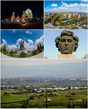
Abovyan
Town in Kotayk, Armenia
Distance: Approx. 717 meters
Latitude and longitude: 40.27388889,44.62555556
Abovyan or Abovian (Armenian: Աբովյան [ɑbɔvˈjɑn]) is a town and urban municipal community in Armenia within the Kotayk Province. It is located 16 kilometres (10 miles) northeast of Yerevan and 32 kilometres (20 miles) southeast of the province centre Hrazdan. As of the 2022 census, the population of the town was 46,434.

Abovyan City Stadium
Soccer stadium in Armenia
Distance: Approx. 378 meters
Latitude and longitude: 40.2684095,44.635241
Vahagn Tumasyan Stadium (Armenian: Վահագն Թումասյանի անվան Մարզադաշտ) is an all-seater football stadium in Abovyan, Armenia.
Aramus, Armenia
Village in Kotayk, Armenia
Distance: Approx. 3391 meters
Latitude and longitude: 40.25111111,44.66305556
Aramus (Armenian: Արամուս) is a village in the Kotayk Province of Armenia. Its located at 43 km of the Getar river and 25 km of the armenian capital, Yerevan.

Balahovit
Place in Kotayk, Armenia
Distance: Approx. 3202 meters
Latitude and longitude: 40.25361111,44.60388889
Balahovit (Armenian: Բալահովիտ, also Romanized as Balaovit) is a village in the Kotayk Province of Armenia. The majority of the early settlers of the village immigrated in 1828-29 from Khoy and Salmast in present-day Iran, while some of the immigrants came from Bulankh. It was renamed Balahovit in 1968 at the request of an Armenian-American group, after one of the eight cantons (gavar) of Sophene in Greater Armenia, of the same name.
Getamej
Place in Kotayk, Armenia
Distance: Approx. 4129 meters
Latitude and longitude: 40.275,44.585
Getamej (Armenian: Գետամեջ, also Romanized as Getamech; until 1948, Ketran) is a town in the Kotayk Province of Armenia. 'Getamej' translates roughly to English as 'Mid-River'.
Katnaghbyur, Kotayk
Town in Kotayk, Armenia
Distance: Approx. 4055 meters
Latitude and longitude: 40.25611111,44.67666667
Katnaghbyur (Armenian: Կաթնաղբյուր, also Romanized as Kat’naghbyur, Katnaghbur, and Katnakhpyur; formerly, Agadzor, Agadarasi) is a town in the Kotayk Province of Armenia.
Verin Ptghni
Place in Kotayk, Armenia
Distance: Approx. 2746 meters
Latitude and longitude: 40.27027778,44.60111111
Verin Ptghni (Armenian: Վերին Պտղնի), is a village in the Kotayk Province of Armenia.
Kotayk (village)
Village in Kotayk, Armenia
Distance: Approx. 2339 meters
Latitude and longitude: 40.275,44.66055556
Kotayk (Armenian: Կոտայք), formerly known as Yelgovan, is a village in the Kotayk Province of Armenia.
Mayakovski, Armenia
Place in Kotayk, Armenia
Distance: Approx. 2187 meters
Latitude and longitude: 40.25222222,44.63833333
Mayakovski (Armenian: Մայակովսկի, also Mayakawvsky) is a village in the Kotayk Province of Armenia.
Nor Gyugh
Place in Kotayk, Armenia
Distance: Approx. 2025 meters
Latitude and longitude: 40.26666667,44.65638889
Nor Gyugh (Armenian: Նոր Գյուղ, also Romanized as Nor Gyukh; formerly, Tazagyukh) is a town in the Kotayk Province of Armenia. 'Nor Gyugh' translates as 'New Village' in English. The village is mainly populated by Armenians but has a Kurdish minority (including Yazidis).
Abovyan mine
Mine in Armenia
Distance: Approx. 3472 meters
Latitude and longitude: 40.3,44.65
The Abovyan mine is a large mine in the center of Armenia in Kotayk Province. Abovyan represents one of the largest iron reserve in Armenia having estimated reserves of 255 million tonnes of ore grading 40% iron.

Saint John the Baptist Church, Abovyan
Distance: Approx. 512 meters
Latitude and longitude: 40.27583333,44.63138889
Saint John the Baptist Church (Armenian: Սուրբ Հովհաննես Մկրտիչ Եկեղեցի, Surp Hovhannes Mkrtich) is a monumental Armenian Apostolic church in the town of Abovyan, Kotayk Province, Armenia.
Weather in this IP's area
overcast clouds
12 Celsius
11 Celsius
12 Celsius
12 Celsius
1015 hPa
70 %
1015 hPa
860 hPa
10000 meters
1.41 m/s
3.05 m/s
23 degree
100 %
06:47:14
19:02:33