31.41.88.127 - IP Lookup: Free IP Address Lookup, Postal Code Lookup, IP Location Lookup, IP ASN, Public IP
Country:
Region:
City:
Location:
Time Zone:
Postal Code:
IP information under different IP Channel
ip-api
Country
Region
City
ASN
Time Zone
ISP
Blacklist
Proxy
Latitude
Longitude
Postal
Route
Luminati
Country
Region
21
City
uzhhorod
ASN
Time Zone
Europe/Kyiv
ISP
New Information Systems PP
Latitude
Longitude
Postal
IPinfo
Country
Region
City
ASN
Time Zone
ISP
Blacklist
Proxy
Latitude
Longitude
Postal
Route
IP2Location
31.41.88.127Country
Region
zakarpatska oblast
City
vyshkovo
Time Zone
Europe/Uzhgorod
ISP
Language
User-Agent
Latitude
Longitude
Postal
db-ip
Country
Region
City
ASN
Time Zone
ISP
Blacklist
Proxy
Latitude
Longitude
Postal
Route
ipdata
Country
Region
City
ASN
Time Zone
ISP
Blacklist
Proxy
Latitude
Longitude
Postal
Route
Popular places and events near this IP address

Cămărzana
Commune in Satu Mare, Romania
Distance: Approx. 9504 meters
Latitude and longitude: 48,23.31666667
Cămărzana ([kəmərˈzana], Hungarian: Komorzán, Hungarian pronunciation: [ˈkomorzaːn]) is a commune of 2,304 inhabitants situated in Satu Mare County, Romania. It is composed of a single village, Cămărzana. The commune is located in the northern part of the county, on the border with Ukraine.

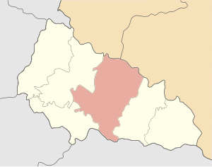
Khust Raion
Subdivision of Zakarpattia Oblast, Ukraine
Distance: Approx. 114 meters
Latitude and longitude: 48.048075,23.42105556
Khust Raion (Ukrainian: Хустський район; Hungarian: Huszti járás) is a raion (district) in Zakarpattia Oblast in western Ukraine. Its administrative center is Khust. Population: 265,845 (2022 estimate).

Oaș Mountains
Distance: Approx. 6682 meters
Latitude and longitude: 47.98944444,23.41111111
The Oaș Mountains (Romanian: Munții Oașului, Hungarian: Avas-hegység, Ukrainian: Гори Оаш) are a small volcanic mountain range within the Vihorlat-Gutin Area of the Inner Eastern Carpathians. The mountains are centered in northern section of the Țara Oașului, covering border area between the Satu Mare County in Romania, and the Zakarpattia Oblast in Ukraine. They are an extension of the Gutin Mountains.
Bushtyno
Rural locality in Zakarpattia Oblast, Ukraine
Distance: Approx. 4165 meters
Latitude and longitude: 48.05361111,23.47666667
Bushtyno (Ukrainian: Буштино [ˈbuʃteno]; Hungarian: Bustyaháza; Romanian: Bustea; Slovak: Buštín; Yiddish: בישטינא) is a rural settlement in Tiachiv Raion, Zakarpattia Oblast, western Ukraine. Bushtyno is located in a small valley where the Tereblia and the Tisza rivers meet. The town's population was 8,506 as of the 2001 Ukrainian census.

Vyshkovo
Rural locality in Zakarpattia Oblast, Ukraine
Distance: Approx. 2390 meters
Latitude and longitude: 48.02888889,23.43194444
Vyshkovo (Ukrainian: Вишкове; Hungarian: Visk) is a rural settlement in Khust Raion, Zakarpattia Oblast, western Ukraine. It is first mentioned in the year 1281. The town's population was 8,142 as of the 2001 Ukrainian Census.

Tereblia (river)
River in Ukraine
Distance: Approx. 4295 meters
Latitude and longitude: 48.0355,23.4751
The Tereblia (Ukrainian: Теребля) is a right tributary of the river Tisza in the Zakarpattia Oblast, western Ukraine. It flows through the villages Synevyr, Kolochava, Drahovo and Tereblia, and discharges into the Tisza in Bushtyno.
Sokyrnytsia
Village in Zakarpattia Oblast, Ukraine
Distance: Approx. 8506 meters
Latitude and longitude: 48.12416667,23.39972222
Sokyrnytsia (Ukrainian: Сокирниця, Romanian: Seclenț, Hungarian: Szeklence) is a village located on the Khust-Synevyr highway near the H09 (Mukachevo-Ivano-Frankivsk-Rohatyn-Lviv) motorway, 10 km from the district center, Khust. It is a village in Khust Raion of Zakarpattia Oblast (province) of western Ukraine. The first mention in the documents dates back to 1389.
Weather in this IP's area
broken clouds
4 Celsius
2 Celsius
3 Celsius
4 Celsius
1030 hPa
76 %
1030 hPa
1006 hPa
10000 meters
2.4 m/s
3.87 m/s
42 degree
77 %
