31.3.87.183 - IP Lookup: Free IP Address Lookup, Postal Code Lookup, IP Location Lookup, IP ASN, Public IP
Country:
 Germany
Region:
City:
Location:
Time Zone:
Postal Code:
ISP:
ASN:
language:
User-Agent:
Proxy IP:
Blacklist:
IP information under different IP Channel
ip-api
Country
Region
City
ASN
Time Zone
ISP
Blacklist
Proxy
Latitude
Longitude
Postal
Route
db-ip
Country
Region
City
ASN
Time Zone
ISP
Blacklist
Proxy
Latitude
Longitude
Postal
Route
IPinfo
Country
Region
City
ASN
Time Zone
ISP
Blacklist
Proxy
Latitude
Longitude
Postal
Route
IP2Location
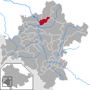
31.3.87.183Country
deRegion
thuringen
City
seligenthal
Time Zone
Europe/Berlin
ISP
Language
User-Agent
Latitude
Longitude
Postal
ipdata
Country
Region
City
ASN
Time Zone
ISP
Blacklist
Proxy
Latitude
Longitude
Postal
Route
Popular places and events near this IP address

Schmalkalden
Town in Thuringia, Germany
Distance: Approx. 5581 meters
Latitude and longitude: 50.71666667,10.45
Schmalkalden (German pronunciation: [ʃmalˈkaldən]) is a town in the Schmalkalden-Meiningen district, in the southwest of the state of Thuringia, Germany. It is on the southern slope of the Thuringian Forest at the Schmalkalde river, a tributary to the Werra. As of 31 December 2022, the town had a population of 20,065.

Brotterode
Stadtteil of Brotterode-Trusetal in Thuringia, Germany
Distance: Approx. 8240 meters
Latitude and longitude: 50.83333333,10.43333333
Brotterode (German pronunciation: [bʁɔtəˈʁoːdə] ) is a town and a former municipality next to the Rennsteig in the Thuringian Forest, in the Schmalkalden-Meiningen district, in Thuringia, central Germany. Since 1 December 2011, it is part of the town Brotterode-Trusetal. It is situated 11 km north of Schmalkalden, and 19 km southeast of Eisenach.

Kleinschmalkalden
Village in Thuringia, Germany
Distance: Approx. 2213 meters
Latitude and longitude: 50.78333333,10.46666667
Kleinschmalkalden is a village on the southern slope of the Thuringian Forest in Landkreis Schmalkalden-Meiningen of Thuringia, Germany. In 2006 it joined the neighbouring municipality Floh-Seligenthal.

Altersbach
Ortsteil of Steinbach-Hallenberg in Thuringia, Germany
Distance: Approx. 8237 meters
Latitude and longitude: 50.7,10.53333333
Altersbach is a village and a former municipality in the district Schmalkalden-Meiningen, in Thuringia, Germany. Since 1 January 2019, it is part of the town Steinbach-Hallenberg.
Fambach
Municipality in Thuringia, Germany
Distance: Approx. 7986 meters
Latitude and longitude: 50.73833333,10.36944444
Fambach is a municipality in the district Schmalkalden-Meiningen, in Thuringia, Germany. Since 1 December 2008 it has incorporated the former municipality of Heßles.

Floh-Seligenthal
Municipality in Thuringia, Germany
Distance: Approx. 1681 meters
Latitude and longitude: 50.75,10.48333333
Floh-Seligenthal is a municipality in the district Schmalkalden-Meiningen, in Thuringia, Germany.

Heßles
Village of Fambach in Thuringia, Germany
Distance: Approx. 4986 meters
Latitude and longitude: 50.75166667,10.40722222
Heßles is a former municipality in the district Schmalkalden-Meiningen, in Thuringia, Germany. Since 1 December 2008, it is part of Fambach.
Rotterode
Ortsteil of Steinbach-Hallenberg in Thuringia, Germany
Distance: Approx. 7997 meters
Latitude and longitude: 50.71111111,10.55166667
Rotterode is a village and a former municipality in the district Schmalkalden-Meiningen, in Thuringia, Germany. Since 1 January 2019, it is part of the town Steinbach-Hallenberg.

Trusetal
Stadtteil of Brotterode-Trusetal in Thuringia, Germany
Distance: Approx. 4638 meters
Latitude and longitude: 50.78333333,10.41666667
Trusetal is a former municipality in the district Schmalkalden-Meiningen, in Thuringia, Germany. Since 1 December 2011, it is part of the town Brotterode-Trusetal.

Stille (river)
River in Thuringia, Germany
Distance: Approx. 5154 meters
Latitude and longitude: 50.722,10.4451
Stille is a river of Thuringia, Germany. It flows into the river Schmalkalde in the town Schmalkalden.

Brotterode-Trusetal
Town in Thuringia, Germany
Distance: Approx. 7075 meters
Latitude and longitude: 50.82494167,10.44563056
Brotterode-Trusetal is a town in the Schmalkalden-Meiningen district, in Thuringia, Germany. It was named after the town Brotterode and the German river Truse that flows through the municipality. It was formed on 1 December 2011 by the merger of the former municipalities Brotterode and Trusetal.

Wilhelmsburg Castle
Building in Schmalkalden, Germany
Distance: Approx. 4779 meters
Latitude and longitude: 50.72305556,10.45583333
The Wilhelmsburg Castle in the city of Schmalkalden was a secondary residence of the Landgraves of Hesse. It is one of the most important Renaissance buildings in central Germany, which has experienced no structural changes to this day and is preserved in almost its original condition.
Weather in this IP's area
light snow
-1 Celsius
-5 Celsius
-1 Celsius
0 Celsius
1017 hPa
91 %
1017 hPa
960 hPa
774 meters
2.72 m/s
4.59 m/s
323 degree
100 %