31.3.139.186 - IP Lookup: Free IP Address Lookup, Postal Code Lookup, IP Location Lookup, IP ASN, Public IP
Country:
Region:
City:
Location:
Time Zone:
Postal Code:
IP information under different IP Channel
ip-api
Country
Region
City
ASN
Time Zone
ISP
Blacklist
Proxy
Latitude
Longitude
Postal
Route
Luminati
Country
ASN
Time Zone
Europe/Paris
ISP
Claranet Limited
Latitude
Longitude
Postal
IPinfo
Country
Region
City
ASN
Time Zone
ISP
Blacklist
Proxy
Latitude
Longitude
Postal
Route
IP2Location
31.3.139.186Country
Region
ile-de-france
City
le coudray-montceaux
Time Zone
Europe/Paris
ISP
Language
User-Agent
Latitude
Longitude
Postal
db-ip
Country
Region
City
ASN
Time Zone
ISP
Blacklist
Proxy
Latitude
Longitude
Postal
Route
ipdata
Country
Region
City
ASN
Time Zone
ISP
Blacklist
Proxy
Latitude
Longitude
Postal
Route
Popular places and events near this IP address

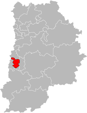
Canton of Savigny-le-Temple
Canton in Île-de-France, France
Distance: Approx. 4998 meters
Latitude and longitude: 48.57416667,2.56611111
The canton of Savigny-le-Temple is a French administrative division that is in the arrondissement of Melun, in the Seine-et-Marne département (Île-de-France région).
Seine-Port
Commune in Île-de-France, France
Distance: Approx. 4037 meters
Latitude and longitude: 48.5569,2.5539
Seine-Port (French pronunciation: [sɛn pɔʁ] ) is a commune in the Seine-et-Marne department in the Île-de-France region in north-central France.

Saint-Fargeau-Ponthierry
Commune in Île-de-France, France
Distance: Approx. 3603 meters
Latitude and longitude: 48.5356,2.5241
Saint-Fargeau-Ponthierry (French: [sɛ̃ faʁʒo pɔ̃tjɛʁi] ) is a commune in the Seine-et-Marne department in the Île-de-France region in north-central France.
Communauté de communes de Seine-École
Former communauté de communes in Île-de-France, France
Distance: Approx. 3603 meters
Latitude and longitude: 48.5356,2.5241
The Communauté de communes de Seine-École is a former federation of municipalities (communauté de communes) in the Seine-et-Marne département and in the Île-de-France région of France. It was created in April 1974. It was merged into the Communauté d'agglomération Melun Val de Seine in January 2016.

Mennecy
Commune in Île-de-France, France
Distance: Approx. 4663 meters
Latitude and longitude: 48.5661,2.4369
Mennecy (French pronunciation: [mɛnsi] ) is a commune in the Essonne department in Île-de-France in northern France.

Auvernaux
Commune in Île-de-France, France
Distance: Approx. 4011 meters
Latitude and longitude: 48.5281,2.4927
Auvernaux (French pronunciation: [ovɛʁno] ) is a commune located in the Essonne department in Île-de-France in northern France. Inhabitants are known as Auvernois in French.

Le Coudray-Montceaux
Commune in Île-de-France, France
Distance: Approx. 1077 meters
Latitude and longitude: 48.5658,2.4858
Le Coudray-Montceaux (French pronunciation: [lə kudʁɛ mɔ̃so] ) is a commune in the Essonne department in Île-de-France in northern France.

Morsang-sur-Seine
Commune in Île-de-France, France
Distance: Approx. 877 meters
Latitude and longitude: 48.5704,2.4936
Morsang-sur-Seine (French pronunciation: [mɔʁsɑ̃ syʁ sɛn] , literally Morsang on Seine) is a commune in the Essonne department in Île-de-France in northern France. Inhabitants of Morsang-sur-Seine are known as Morsandiaux. The orientalist Rubens Duval (1839–1911) was born in Morsang-sur-Seine.

Ormoy, Essonne
Commune in Île-de-France, France
Distance: Approx. 4176 meters
Latitude and longitude: 48.5762,2.4466
Ormoy (French pronunciation: [ɔʁmwa] ) is a commune in the Essonne department in Île-de-France in northern France.

Saintry-sur-Seine
Commune in Île-de-France, France
Distance: Approx. 3646 meters
Latitude and longitude: 48.5962,2.4929
Saintry-sur-Seine (French pronunciation: [sɛ̃tʁi syʁ sɛn] , literally Saintry on Seine) is a commune in the Essonne department in Île-de-France in northern France.

Villabé
Commune in Île-de-France, France
Distance: Approx. 4433 meters
Latitude and longitude: 48.589,2.4535
Villabé (French pronunciation: [vilabe] ) is a commune in the Essonne department in Île-de-France in northern France.

Canton of Saint-Fargeau-Ponthierry
Canton in Île-de-France, France
Distance: Approx. 5005 meters
Latitude and longitude: 48.5333,2.55
The canton of Saint-Fargeau-Ponthierry is a French administrative division, located in the arrondissement of Melun, in the Seine-et-Marne département (Île-de-France région).
Weather in this IP's area
clear sky
-1 Celsius
-3 Celsius
-1 Celsius
1 Celsius
1041 hPa
93 %
1041 hPa
1031 hPa
10000 meters
1.54 m/s
