Country:
 Netherlands
Region:
City:
Latitude and Longitude:
Time Zone:
Postal Code:
IP information under different IP Channel
ip-api
Country
Region
City
ASN
Time Zone
ISP
Blacklist
Proxy
Latitude
Longitude
Postal
Route
IPinfo
Country
Region
City
ASN
Time Zone
ISP
Blacklist
Proxy
Latitude
Longitude
Postal
Route
MaxMind
Country
Region
City
ASN
Time Zone
ISP
Blacklist
Proxy
Latitude
Longitude
Postal
Route
Luminati
Country
NLRegion
nb
City
dongen
ASN
Time Zone
Europe/Amsterdam
ISP
The Internet Engineering Group B.V.
Latitude
Longitude
Postal
db-ip
Country
Region
City
ASN
Time Zone
ISP
Blacklist
Proxy
Latitude
Longitude
Postal
Route
ipdata
Country
Region
City
ASN
Time Zone
ISP
Blacklist
Proxy
Latitude
Longitude
Postal
Route
Popular places and events near this IP address

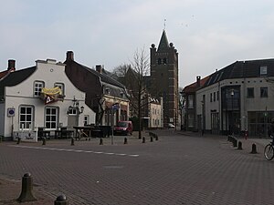
Dongen
Municipality in North Brabant, Netherlands
Distance: Approx. 1673 meters
Latitude and longitude: 51.63333333,4.93333333
Dongen (Dutch pronunciation: [ˈdɔŋə(n)] ) is a municipality and village in North Brabant, in the southern Netherlands. In the past it had a profitable leather industry, and a few old shoe factories in the town's older sections remain. The town is near a small river called the Donge, the water of which was used extensively for the leather industry.
Gilze en Rijen
Municipality in North Brabant, Netherlands
Distance: Approx. 4164 meters
Latitude and longitude: 51.58333333,4.91666667
Gilze en Rijen (Dutch pronunciation: [ˌɣɪlzə ʔɛn ˈrɛiə(n)] ) is a municipality in the southern Netherlands. The municipality contains four villages: Rijen, Gilze, Hulten and Molenschot. It is home to the Gilze-Rijen Air Base.

Oosterhout
Municipality in North Brabant, Netherlands
Distance: Approx. 5146 meters
Latitude and longitude: 51.63333333,4.86666667
Oosterhout (Dutch pronunciation: [ˈoːstərɦʌut] ; from ooster, "eastern", and hout, "woods") is a municipality and a city in southern Netherlands. The municipality had a population of 56,206 in 2021.

Gilze-Rijen Air Base
Military airport in North Brabant, Netherlands
Distance: Approx. 5721 meters
Latitude and longitude: 51.56722222,4.93166667
Gilze-Rijen Air Base (Dutch: Vliegbasis Gilze-Rijen, IATA: GLZ, ICAO: EHGR) is a military airbase in the south of Netherlands. It is known for having the hottest temperature ever measured in the Netherlands, with a temperature of 40.7 °C, on July 25, 2019. It is between the cities of Breda and Tilburg, which are both in North Brabant.

's Gravenmoer
Village in North Brabant, Netherlands
Distance: Approx. 4473 meters
Latitude and longitude: 51.65861111,4.94111111
's Gravenmoer is a village in the Dutch province of North Brabant. It is located in the municipality of Dongen, about 3 km north of the town of Dongen. The village has a population of about 2190 inhabitants, including the farmlands to the north of the village.

Rijen
Town in North Brabant, Netherlands
Distance: Approx. 4014 meters
Latitude and longitude: 51.58333333,4.95
Rijen is the largest place in the Dutch municipality of Gilze en Rijen. The city hall is located here. Rijen is situated north of the A58, between Breda and Tilburg.
Heikant, Rijen
Distance: Approx. 3309 meters
Latitude and longitude: 51.59416667,4.90972222
Heikant is a former hamlet in the Dutch province of North Brabant. It was located in the municipality of Gilze en Rijen, about 1 km west of the centre of Rijen. According to the 19th-century historian A.J. van der Aa, Heikant (or "De Heikant") consisted of 8 houses and had a population of 60 in the middle of the 19th century.
Heikant, Oosterhout
Hamlet in Oosterhout, the Netherlands
Distance: Approx. 4069 meters
Latitude and longitude: 51.63666667,4.88611111
Heikant is a hamlet in the municipality of Oosterhout, in the Dutch province of North Brabant. It is located about 3 km southeast of the centre of Oosterhout.

Gilze-Rijen railway station
Railway station in the Netherlands
Distance: Approx. 3944 meters
Latitude and longitude: 51.58388889,4.925
Gilze-Rijen is a railway station located in Rijen, Netherlands in the municipality Gilze en Rijen. Although the railway station is located in Rijen, it's called Gilze-Rijen because of the Gilze-Rijen Air Base, just south of Rijen. The station was opened on 5 October 1863 and is located on the Breda–Eindhoven railway between Breda and Tilburg.

Reeshof
Place in North Brabant, Netherlands
Distance: Approx. 5886 meters
Latitude and longitude: 51.57875,4.99333333
The Reeshof (also known as Tilburg Reeshof), is a district of the municipality Tilburg in the Netherlands. The district has 42,696 inhabitants, which makes the Reeshof the largest district of Tilburg. The Reeshof mostly consists of new-built houses from 1980 or later.
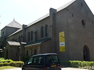
St. Paul's Abbey, Oosterhout
Distance: Approx. 4796 meters
Latitude and longitude: 51.63818056,4.87546111
St. Paul's Abbey, Oosterhout, also Oosterhout Abbey (Dutch: Sint-Paulusabdij) is a former Benedictine abbey in Oosterhout, North Brabant, the Netherlands.

Tesla facilities in Tilburg
Overview of the several factory buildings of Tesla in Vossenberg, Tilburg, Netherlands
Distance: Approx. 4757 meters
Latitude and longitude: 51.606,5.003
Tesla, Inc. has several factory buildings in the industrial zone of Vossenberg, Tilburg, in the Netherlands. In December 2012, a European Distribution Centre in Tilburg was announced, acting as the European parts and services headquarters.
Weather in this IP's area
broken clouds
21 Celsius
21 Celsius
21 Celsius
23 Celsius
1007 hPa
58 %
1007 hPa
1007 hPa
10000 meters
6.17 m/s
190 degree
75 %
07:04:29
20:11:33