Country:
Region:
City:
Latitude and Longitude:
Time Zone:
Postal Code:
IP information under different IP Channel
ip-api
Country
Region
City
ASN
Time Zone
ISP
Blacklist
Proxy
Latitude
Longitude
Postal
Route
IPinfo
Country
Region
City
ASN
Time Zone
ISP
Blacklist
Proxy
Latitude
Longitude
Postal
Route
MaxMind
Country
Region
City
ASN
Time Zone
ISP
Blacklist
Proxy
Latitude
Longitude
Postal
Route
Luminati
Country
ASN
Time Zone
Asia/Tokyo
ISP
G-Core Labs S.A.
Latitude
Longitude
Postal
db-ip
Country
Region
City
ASN
Time Zone
ISP
Blacklist
Proxy
Latitude
Longitude
Postal
Route
ipdata
Country
Region
City
ASN
Time Zone
ISP
Blacklist
Proxy
Latitude
Longitude
Postal
Route
Popular places and events near this IP address
Harumi Island Triton Square
Skyscraper in Japan
Distance: Approx. 882 meters
Latitude and longitude: 35.65751,139.78377
Harumi Island Triton Square (晴海アイランドトリトンスクエア, Harumi-airando-toriton-sukuea) is high-rise office and residential complex in the Harumi district of Chūō, Tokyo, Japan. It consists of four towers, one of which is significantly shorter than the others; the three tall towers are the source of the name "Triton", and the total number of four is the source of the name "Square". Triton Square is located near Kachidoki Station on the Toei Oedo Line and Tsukishima Station on the Tokyo Metro Yurakucho Line.
Shibaura Institute of Technology
Distance: Approx. 952 meters
Latitude and longitude: 35.66027778,139.79444444
The Shibaura Institute of Technology (芝浦工業大学, Shibaura Kōgyō Daigaku), abbreviated as Shibaura kōdai (芝浦工大, Shibaura kōdai), is a private university with the main campus located in Koto, Tokyo, Japan, with campuses located in Tokyo and Saitama. Established in 1927 as the Tokyo Higher School of Industry and Commerce, it was chartered as a university in 1949. The Shibaura Institute of Technology enjoys a moderately high reputation nationally, ranking 26th in the 2017 edition of Truly Strong Universities, 28th in Times Higher Education Japan University rankings for 2022 (out of 775 institutions), and joint 6th among private universities in terms of entry difficulty (in STEM).

Toyosu Station
Metro and railway station in Tokyo, Japan
Distance: Approx. 555 meters
Latitude and longitude: 35.654995,139.796079
Toyosu Station (豊洲駅, Toyosu-eki) is a railway station in Kōtō, Tokyo, Japan, operated by Tokyo Metro and Yurikamome.
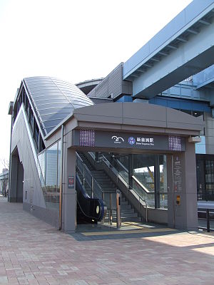
Shin-toyosu Station
Railway station in Tokyo, Japan
Distance: Approx. 424 meters
Latitude and longitude: 35.6485,139.7899
Shin-toyosu Station (新豊洲駅, Shin-Toyosu-eki) is a railway station on the Yurikamome Line, in Kōtō, Tokyo, Japan. It is numbered "U-15".

Shijō-mae Station
Railway station in Tokyo, Japan
Distance: Approx. 865 meters
Latitude and longitude: 35.6459,139.7854
Shijō-mae Station (市場前駅, Shijōmae-eki) is a station on the Yurikamome Line in Kōtō, Tokyo, Japan. The station is numbered "U-14".
Toyosu
Neighborhood in Kōtō, Tokyo, Japan
Distance: Approx. 558 meters
Latitude and longitude: 35.655,139.79611111
Toyosu (豊洲) is neighborhood in Kōtō, Tokyo. Toyosu has six numbered chome ("blocks"). It is the location of the wholesale Toyosu Market, which took the role of the Tsukiji fish market after it became solely a tourist attraction.

KidZania Tokyo
Family edutainment center amusement park
Distance: Approx. 413 meters
Latitude and longitude: 35.65583333,139.79194444
KidZania Tokyo is a family edutainment center amusement park, in the LaLaport Toyosu, Tokyo, Japan opened in October 2006. A part of the Kidzania franchise, Kidzania Tokyo is the third ever Kidzania theme park ever built, preceded by Mexico City and Monterrey, and succeeded by Kidzania Jakarta. As like other Kidzania Theme parks, the Tokyo franchise offers 70 occupations for enjoyment by children; nevertheless, it was nearly identical to any other Kidzania theme parks in the franchise.

1855 Edo earthquake
Earthquake in Japan
Distance: Approx. 850 meters
Latitude and longitude: 35.65,139.8
The 1855 Edo earthquake (安政江戸地震, Ansei Edo Jishin), was the third Ansei Great Earthquake, which occurred during the late-Edo period. It occurred after the 1854 Nankai earthquake, which took place about a year prior. The earthquake occurred at 22:00 local time on 11 November.
IBM Toyosu Facility
Distance: Approx. 772 meters
Latitude and longitude: 35.6506,139.7993
IBM Toyosu Facility, located in Toyosu, Kōtō-ku, Tokyo, Japan, is one of the two largest facilities occupied by IBM in Tokyo, the other being IBM Hakozaki Facility. It mainly houses IBM's research and development, and delivery functions. The building is owned by Nippon Building Fund, affiliated to Mitsui Bank, and was built in 2004.
Toyosu Ciel Tower
Residential building in Tokyo, Japan
Distance: Approx. 507 meters
Latitude and longitude: 35.653725,139.79628
The Toyosu Ciel Tower (豊洲シエルタワー) is a residential building in the Koto special ward of Tokyo, Japan. Completed in September 2006, it stands at 144.4 m (474 ft) tall.
TeamLab Planets TOKYO DMM.com
Art facility in Tokyo, Japan
Distance: Approx. 354 meters
Latitude and longitude: 35.6492,139.7897
teamLab Planets TOKYO DMM.com is an art facility that utilizes digital technology and was established by teamLab and DMM.com. It is located in 6-chome, Toyosu, Koto-ku, Tokyo.

Harumi, Tokyo
District in Tokyo, Japan
Distance: Approx. 998 meters
Latitude and longitude: 35.659675,139.7849
Harumi (晴海) is a district of Chūō, Tokyo. The district contains five chōme (subdivisions), and the postal code is 104-0053. Harumi is located on reclaimed land, created by dropping earth and sediment generated from expanding Tokyo Bay.
Weather in this IP's area
scattered clouds
29 Celsius
34 Celsius
27 Celsius
29 Celsius
1014 hPa
80 %
1014 hPa
1013 hPa
10000 meters
5.14 m/s
180 degree
40 %
05:18:16
17:59:13


