Country:
Region:
City:
Latitude and Longitude:
Time Zone:
Postal Code:
IP information under different IP Channel
ip-api
Country
Region
City
ASN
Time Zone
ISP
Blacklist
Proxy
Latitude
Longitude
Postal
Route
Luminati
Country
Region
08
City
albufeira
ASN
Time Zone
Europe/Lisbon
ISP
Servicos De Comunicacoes E Multimedia S.A.
Latitude
Longitude
Postal
IPinfo
Country
Region
City
ASN
Time Zone
ISP
Blacklist
Proxy
Latitude
Longitude
Postal
Route
db-ip
Country
Region
City
ASN
Time Zone
ISP
Blacklist
Proxy
Latitude
Longitude
Postal
Route
ipdata
Country
Region
City
ASN
Time Zone
ISP
Blacklist
Proxy
Latitude
Longitude
Postal
Route
Popular places and events near this IP address

Palmela
Municipality in Lisbon Region, Portugal
Distance: Approx. 7691 meters
Latitude and longitude: 38.56666667,-8.9
Palmela (Portuguese pronunciation: [palˈmɛlɐ] ) is a town and municipality in Portugal. As of 2011, the population was 62,831, covering an area of 465.12 km². The municipality is located in the Lisboa Region and Setúbal District, about 25 km (16 mi) south of Lisbon.

Pinhal Novo
Civil parish in Lisbon Region, Portugal
Distance: Approx. 429 meters
Latitude and longitude: 38.631,-8.914
Pinhal Novo (Portuguese pronunciation: [piˈɲal ˈnovu]) is a town in Portugal situated in the Setúbal Peninsula halfway between Lisbon and Setúbal. It is a civil parish of the Palmela Municipality. The population in 2011 was 25,000, in an area of 54.44 km2.

Moita
Municipality in Setúbal District, Portugal
Distance: Approx. 6147 meters
Latitude and longitude: 38.65,-8.98333333
Moita (pronounced [ˈmojtɐ] ) is a municipality in the district of Setúbal in Portugal. The population in 2011 was 66,029, in an area of 55.26 km2. The municipality is part of the Greater Lisbon Area, with a demographic rate of 1.194,9/km2 in 2011, growing from 533,2/km2 in 1960.

Montijo, Portugal
Municipality in Lisbon, Portugal
Distance: Approx. 5577 meters
Latitude and longitude: 38.68333333,-8.9
Montijo (Portuguese pronunciation: [mõˈtiʒu] ) is a city and municipality in Setúbal District in Portugal. Its name was Aldeia Galega do Ribatejo or simply Aldeia Galega until 1930. The population in 2021 was 55,732, in an area of 348.62 km2.

Setúbal Peninsula
Distance: Approx. 9320 meters
Latitude and longitude: 38.58333333,-9
The Setúbal Peninsula (Portuguese: Península de Setúbal) is a peninsula in the Lisbon Region of Portugal. The peninsula is named after one of its larger cities, Setúbal, and is bordered by three bodies of water, the Atlantic Ocean in the west and southwest, the Tagus Estuary to the north and the Sado Estuary to the southeast. The region can be divided into two different orographic zones: the mountainous southwest, formed by the Arrábida mountain range, cut by valleys and hills, with altitudes between 100 and 500 m (330 and 1,640 ft), and the remaining extensive flat areas, part of the Tagus floodplain.

Sarilhos Pequenos
Civil parish in Lisbon, Portugal
Distance: Approx. 7797 meters
Latitude and longitude: 38.68166667,-8.98194444
Sarilhos Pequenos is town on the south margin of the Tagus River, near Lisbon, Portugal. Once a civil parish in the municipality of Moita, in the district of Setúbal, it merged in 2013 into the new parish of Gaio-Rosário e Sarilhos Pequenos. With an area of approximately 3.79 square kilometres (1.46 sq mi), the population of Sarilhos Pequenos was 1150 in 2011 (census data).

Montijo (parish)
Civil parish in Lisbon, Portugal
Distance: Approx. 8526 meters
Latitude and longitude: 38.7,-8.96666667
Montijo is a former civil parish in the municipality of Montijo, central Portugal. In 2013, the parish merged into the new parish Montijo e Afonsoeiro. The population in 2021 was 55,732, in an area of 27.25 square kilometres (10.52 sq mi) km2.

Castle of Palmela
Castle in Palmela, Setúbal, Portugal
Distance: Approx. 7736 meters
Latitude and longitude: 38.56611111,-8.90111111
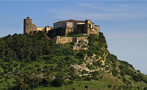
Castle of Palmela is a castle in Portugal. It is classified as a National Monument. The Castle of Palmela is located in the village, parish and county of the same name, district of Setúbal, in Portugal .
Igreja de Santiago de Palmela
Distance: Approx. 7762 meters
Latitude and longitude: 38.5655916,-8.9035781
Igreja de Santiago de Palmela is a church in Portugal. It is classified as a National Monument. Construction first began in 1443, and the church was completed in 1482.
Gaio-Rosário e Sarilhos Pequenos
Civil parish in Lisbon, Portugal
Distance: Approx. 8339 meters
Latitude and longitude: 38.67,-9
Gaio-Rosário e Sarilhos Pequenos is a civil parish in the municipality of Moita, Portugal. It was formed in 2013 by the merger of the former parishes of Gaio-Rosário and Sarilhos Pequenos, respectively. The population in 2011 was 2,377, in an area of 14.12 km2.

Artificial caves of Casal do Pardo
Prehistoric necropolis near Setúbal, Portugal
Distance: Approx. 8107 meters
Latitude and longitude: 38.56416667,-8.93861111
The four Artificial caves of Casal do Pardo (Portuguese: Grutas artificiais do Casal do Pardo), also known as the Caves of Quinta do Anjo, were neolithic tombs. They are situated in Palmela municipality in the Setúbal District, of Portugal, about 25 km (16 mi) south of the capital of Lisbon. These caves were classified as a National Monument of Portugal in 1934.

Castro of Chibanes
Chalcolithic and Roman site in Portugal
Distance: Approx. 7888 meters
Latitude and longitude: 38.56388889,-8.91861111
The Castro of Chibanes is located in the Arrábida Nature Park, on the Serra do Louro (Louro Hill), in the municipality of Palmela in the Setúbal District of Portugal, about 25 km (16 mi) south of the capital of Lisbon, which can be seen from the site. The Castro, or hill fort, is located at the top of the hill, naturally defended by a scarp to the south. It covers about one hectare and was first occupied in about 2900 BCE, during the Chalcolithic or Copper Age.
Weather in this IP's area
light rain
14 Celsius
13 Celsius
14 Celsius
15 Celsius
1016 hPa
63 %
1016 hPa
1011 hPa
10000 meters
2.52 m/s
6.38 m/s
109 degree
100 %
07:20:24
17:21:16