Country:
Region:
City:
Latitude and Longitude:
Time Zone:
Postal Code:
IP information under different IP Channel
ip-api
Country
Region
City
ASN
Time Zone
ISP
Blacklist
Proxy
Latitude
Longitude
Postal
Route
Luminati
Country
Region
18
City
paus
ASN
Time Zone
Europe/Lisbon
ISP
Servicos De Comunicacoes E Multimedia S.A.
Latitude
Longitude
Postal
IPinfo
Country
Region
City
ASN
Time Zone
ISP
Blacklist
Proxy
Latitude
Longitude
Postal
Route
db-ip
Country
Region
City
ASN
Time Zone
ISP
Blacklist
Proxy
Latitude
Longitude
Postal
Route
ipdata
Country
Region
City
ASN
Time Zone
ISP
Blacklist
Proxy
Latitude
Longitude
Postal
Route
Popular places and events near this IP address

Tarouca
Municipality in Norte, Portugal
Distance: Approx. 1808 meters
Latitude and longitude: 41.01666667,-7.76666667
Tarouca (European Portuguese pronunciation: [tɐˈɾokɐ] ) is a municipality and a city in Viseu District in Norte Region and Douro Subregion in Portugal. The population in 2011 was 8,046, in an area of 100.08 km2. The city of Tarouca proper has about 3,400 residents; it was promoted to city in December 2004.
Sever, Moimenta da Beira
Civil parish in Norte, Portugal
Distance: Approx. 3903 meters
Latitude and longitude: 41.001,-7.706
Sever is a civil parish in the municipality of Moimenta da Beira, northern Portugal. The population in 2011 was 536, in an area of 10.03 km2.
Britiande
Civil parish in Norte, Portugal
Distance: Approx. 6275 meters
Latitude and longitude: 41.063,-7.793
Britiande is a town in Portugal. It is a parish of Lamego Municipality. The population in 2011 was 934, in an area of 4.80 km2.
Lalim
Civil parish in Norte, Portugal
Distance: Approx. 6308 meters
Latitude and longitude: 41.039,-7.816
Lalim is a civil parish (freguesia) in Lamego Municipality in the Viseu District of the Norte Region of Portugal. The population in 2011 was 729, in an area of 7.22 km².
Lazarim
Civil parish in Norte, Portugal
Distance: Approx. 8878 meters
Latitude and longitude: 41.015,-7.851
Lazarim is a town in Portugal. It is a parish of Lamego Municipality. The population in 2011 was 521, in an area of 16.54 km2.
Mondim da Beira
Civil parish in Norte, Portugal
Distance: Approx. 410 meters
Latitude and longitude: 41.016,-7.747
Mondim da Beira is a civil parish in the municipality of Tarouca, Portugal. The population in 2011 was 786, in an area of 7.08 km2. Particularly notable is the presence of a Roman bridge made between the 13th and 14th centuries.
Almofala
Civil parish in Centro, Portugal
Distance: Approx. 8411 meters
Latitude and longitude: 40.953,-7.793
[1] is a civil parish in the municipality of Castro Daire, Portugal. The population in 2011 was 228, in an area of 18.60 km2.

Our Lady of the Assumption Cathedral, Lamego
Church in Lamego, Portugal
Distance: Approx. 9999 meters
Latitude and longitude: 41.0965,-7.8068
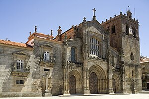
The Our Lady of the Assumption Cathedral (Portuguese: Sé Catedral de Nossa Senhora da Assunção) also called Lamego Cathedral is a religious building affiliated with the Catholic Church that was founded in 1129. It is located in the city of Portuguese city of Lamego The temple follows the Roman or Latin rite and serves as the seat of the diocese of Lamego (Dioecesis Lamacensis or Diocese de Lamego) that was created about 570. It is a cathedral built in Gothic style, which preserves the bell tower original square, but the rest of the architecture reflects the changes made in the sixteenth and eighteenth centuries, including a Renaissance cloister with a dozen arches and well proportioned.
Granja Nova
Civil parish in the municipality of Tarouca, Portugal
Distance: Approx. 2440 meters
Latitude and longitude: 41.016667,-7.716667
Granja Nova is a civil parish in the municipality of Tarouca, Portugal. The population in 2011 was 396 and the population density was 57 inhabitants per square kilometre, in an area of 6.86 km2.

Salzedas
Civil parish in the municipality of Tarouca, Portugal
Distance: Approx. 4169 meters
Latitude and longitude: 41.05,-7.716667
Salzedas is a civil parish in the municipality of Tarouca, Portugal. The population in 2011 was 767 and population density was 86 inhabitants per square kilometre, in an area of 8.92 km2.

São João de Tarouca
Civil parish in the municipality of Tarouca, Portugal
Distance: Approx. 4153 meters
Latitude and longitude: 40.983333,-7.733333
São João de Tarouca is a civil parish in the municipality of Tarouca, Portugal. The population in 2011 was 606 and population density was 27 inhabitants per square kilometre, in an area of 22.46 km2.
Weather in this IP's area
scattered clouds
8 Celsius
6 Celsius
8 Celsius
8 Celsius
1020 hPa
90 %
1020 hPa
958 hPa
10000 meters
2.14 m/s
2.54 m/s
67 degree
38 %
07:21:22
17:10:56