Country:
Region:
City:
Latitude and Longitude:
Time Zone:
Postal Code:
IP information under different IP Channel
ip-api
Country
Region
City
ASN
Time Zone
ISP
Blacklist
Proxy
Latitude
Longitude
Postal
Route
Luminati
Country
Region
14
City
fatima
ASN
Time Zone
Europe/Lisbon
ISP
Servicos De Comunicacoes E Multimedia S.A.
Latitude
Longitude
Postal
IPinfo
Country
Region
City
ASN
Time Zone
ISP
Blacklist
Proxy
Latitude
Longitude
Postal
Route
db-ip
Country
Region
City
ASN
Time Zone
ISP
Blacklist
Proxy
Latitude
Longitude
Postal
Route
ipdata
Country
Region
City
ASN
Time Zone
ISP
Blacklist
Proxy
Latitude
Longitude
Postal
Route
Popular places and events near this IP address
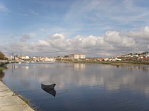
Vila do Conde
Municipality in Norte, Portugal
Distance: Approx. 83 meters
Latitude and longitude: 41.35277778,-8.74444444
Vila do Conde (pronounced [ˈvilɐ ðu ˈkõdɨ] , locally [ˈbilɐ ðu ˈkoŋdɨ]; "the Count's Town") is a municipality in the Norte Region of Portugal. The population in 2011 was 79,533, in an area of 149.03 km2. The urbanized area of Vila do Conde, which includes the parishes of Vila do Conde, Azurara and Árvore, represent 36,137 inhabitants.
Estádio dos Arcos
Stadium in Vila do Conde, Portugal
Distance: Approx. 1131 meters
Latitude and longitude: 41.36277778,-8.74027778
Estadio dos Arcos is a multi-use stadium in Vila do Conde, Portugal. It is used mostly for football matches of Primeira Liga club Rio Ave. The stadium is able to hold 12,815 people and was built in 1985.

Monastery of Santa Clara
Distance: Approx. 509 meters
Latitude and longitude: 41.3525,-8.73916667
Monastery of Santa Clara or Convent of Santa Clara in Vila do Conde, Portugal was one of the biggest and richest feminine convents in Portugal, founded in 1318, by Afonso Sanches and his wife, Teresa Martins Telo. The large historical complex includes the Gothic Santa Clara Church (1318), nearby Manueline late Gothic constructions and the current proper monastery, built in the early phase of the neoclassical style in 1777. The Monastery is located in a hilltop and includes large walls that protect the monastery from the east and the Santa Clara Aqueduct, the second largest aqueduct in Portugal.
Argivai
Distance: Approx. 2756 meters
Latitude and longitude: 41.376,-8.732
Argivai is an urban area in Póvoa de Varzim, Portugal. It is an ancient ecclesiastical parish and former civil parish located in the city of Póvoa de Varzim. In the census of 2001, it had a population of 2,187 inhabitants and a total area of 2.32 km2.

Santa Clara Aqueduct
Aqueduct in Vila do Conde, Portugal
Distance: Approx. 549 meters
Latitude and longitude: 41.35630556,-8.73994444
The Aqueduct of Santa Clara is the second largest Portuguese aqueduct system. Built between 1626 and 1714, it includes 999 arches stretching for 4 kilometres (2.5 mi) from the spring of Terroso in the municipality of Póvoa de Varzim to the Convent of Santa Clara in the municipality of Vila do Conde.

Lapa Church
Distance: Approx. 2661 meters
Latitude and longitude: 41.37381111,-8.76151667
Lapa Church, officially Parish Church of Our Lady of Lapa (Portuguese: Igreja Paroquial de Nossa Senhora da Lapa) is a Parish church in the Portuguese city of Póvoa de Varzim. It was built in 1772 by the local fishermen community. Despite its simplicity it has some interesting features and cultural interest such its old lighthouse, once a link between the church and the fishermen at sea.
Ave River
River in northern Portugal
Distance: Approx. 1578 meters
Latitude and longitude: 41.3393,-8.74811
Ave River (Portuguese: Rio Ave; Portuguese pronunciation: [ˈʁiu ˈavɨ]) is a river in Northern Portugal. It has its source in the Cabreira Mountain (Serra da Cabreira) in the Minho Region. In its course passes through the cities of Guimarães, Vizela, Santo Tirso, Trofa and Vila do Conde.
Igreja Matriz de Vila do Conde
Distance: Approx. 232 meters
Latitude and longitude: 41.35388889,-8.7425
Igreja Matriz de Vila do Conde is a church in Portugal. It is classified as a National Monument.

Farol da Lapa
Lighthouse in Portugal
Distance: Approx. 2663 meters
Latitude and longitude: 41.373796,-8.761595
Farol da Lapa (Portuguese for Lighthouse of (the) Lapa) is a lighthouse in Póvoa de Varzim, Portugal, on the seaport of Póvoa de Varzim in Póvoa Bay.

Farol de Regufe
Lighthouse
Distance: Approx. 2479 meters
Latitude and longitude: 41.374387,-8.754706
Farol de Regufe or Regufe Light is a lighthouse in Póvoa de Varzim, Portugal, located in the city neighborhood of Regufe, origin of the lighthouse's naming.
Port of Póvoa de Varzim
Distance: Approx. 2842 meters
Latitude and longitude: 41.37388889,-8.76527778
The Port of Póvoa de Varzim is a seaport built in Enseada da Póvoa Bay in the city of Póvoa de Varzim in Portugal. During the Middle Ages, it was known as Port of Varzim (Porto de Veracim in Old Portuguese). Once used for trade and shipbuilding, it is currently used for fishing and recreation, with a marina located within its breakwaters.

Fort São João Baptista (Vila do Conde)
Distance: Approx. 1405 meters
Latitude and longitude: 41.34166667,-8.75166667
Fort São João Baptista (Forte de São João Baptista in Portuguese), also known as Fort of Nossa Senhora da Assunção (Forte da Nossa Senhora da Assunção in Portuguese), is located at the mouth of the river Ave, in the town of Vila do Conde, district of Porto, in Portugal. It is currently in good condition and open for visitors.
Weather in this IP's area
clear sky
16 Celsius
16 Celsius
11 Celsius
16 Celsius
1017 hPa
63 %
1017 hPa
1016 hPa
10000 meters
3.6 m/s
90 degree
07:26:12
17:14:07


