31.214.246.191 - IP Lookup: Free IP Address Lookup, Postal Code Lookup, IP Location Lookup, IP ASN, Public IP
Country:
 Germany
Region:
City:
Location:
Time Zone:
Postal Code:
ISP:
ASN:
language:
User-Agent:
Proxy IP:
Blacklist:
IP information under different IP Channel
ip-api
Country
Region
City
ASN
Time Zone
ISP
Blacklist
Proxy
Latitude
Longitude
Postal
Route
db-ip
Country
Region
City
ASN
Time Zone
ISP
Blacklist
Proxy
Latitude
Longitude
Postal
Route
IPinfo
Country
Region
City
ASN
Time Zone
ISP
Blacklist
Proxy
Latitude
Longitude
Postal
Route
IP2Location
31.214.246.191Country
deRegion
baden-wurttemberg
City
markdorf
Time Zone
Europe/Berlin
ISP
Language
User-Agent
Latitude
Longitude
Postal
ipdata
Country
Region
City
ASN
Time Zone
ISP
Blacklist
Proxy
Latitude
Longitude
Postal
Route
Popular places and events near this IP address

Bodenseekreis
District in Baden-Württemberg, Germany
Distance: Approx. 1658 meters
Latitude and longitude: 47.73333333,9.38333333
Bodenseekreis ("Lake Constance district") is a Landkreis (district) in the south-east of Baden-Württemberg, Germany. Neighboring districts are (from west, clockwise) Konstanz, Sigmaringen and Ravensburg, and in Bavaria, Lindau district. To the south, on the opposite shores of Lake Constance, lies Switzerland.

Immenstaad am Bodensee
Municipality in Baden-Württemberg, Germany
Distance: Approx. 6110 meters
Latitude and longitude: 47.66666667,9.36666667
Immenstaad am Bodensee is a municipality in Baden-Württemberg, Germany, on the north shore of Lake Constance (called the Bodensee in German) near the Austrian and Swiss borders. It is not to be confused with the similarly named town of Immenstadt, approximately 85 km East in Bavaria.

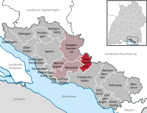
Markdorf
Town in Baden-Württemberg, Germany
Distance: Approx. 209 meters
Latitude and longitude: 47.72083333,9.39166667
Markdorf is a town in the Bodenseekreis district, in Baden-Württemberg, Southern Germany. It is situated near Lake Constance, 10 km northwest of Friedrichshafen. Georg Riedmann has been the mayor of Markdorf since 2013.

Bermatingen
Municipality in Baden-Württemberg, Germany
Distance: Approx. 3215 meters
Latitude and longitude: 47.72916667,9.35
Bermatingen is a commune in the district of Bodensee in Baden-Württemberg in Germany.
Oberteuringen
Municipality in Baden-Württemberg, Germany
Distance: Approx. 6065 meters
Latitude and longitude: 47.725,9.47083333
Oberteuringen is a town in the district of Bodensee in Baden-Württemberg, south-west Germany. It lies some 8 km north of the Bodensee (Lake Constance) and 4 km east of Mount Gehrenberg. Nearby towns are Markdorf (6 km), Friedrichshafen (7 km), Tettnang (11 km), and Ravensburg (12 km).

Gehrenberg Tower
Observation tower on Gehrenberg mountain in Baden-Württemberg. Germany
Distance: Approx. 2140 meters
Latitude and longitude: 47.73611111,9.40388889
Gehrenberg Tower is a 30 metres tall observation tower of lattice steel on Gehrenberg, a 754 m high mountain north of Markdorf, standing at an elevation of 704 m. Gehrenberg Tower has some similarities to Eiffel Tower as it also has a bow between its feet. From the observation deck of Gehrenberg Tower, one can see at clear weather the Alps and the Höchsten mountain.
Rammetshofen
Village in Baden Wuerttemberg, Germany
Distance: Approx. 5726 meters
Latitude and longitude: 47.71666667,9.46666667
Rammetshofen is a village located 1.6 kilometres (1 mile) south of Oberteuringen in the Bodenseekreis of the federal state of Baden-Württemberg in Germany. It lies approximately 7.5 kilometres (4.7 mi) north of the Bodensee.

Untersiggingen
Village in Baden-Württemberg, Germany
Distance: Approx. 6337 meters
Latitude and longitude: 47.77555556,9.37833333
Untersiggingen is a village in the municipality Deggenhausertal in Baden-Württemberg Germany. Deggenhausertal itself is a part of the district Bodenseekreis which is on the north shore of Lake Constanz.

Gehrenberg
Distance: Approx. 2525 meters
Latitude and longitude: 47.73333333,9.41666667
Gehrenberg is a mountain of Baden-Württemberg, Germany.
Brunnisach
River in Germany
Distance: Approx. 5897 meters
Latitude and longitude: 47.6679,9.4099
The Brunnisach is a river in Baden-Württemberg, Germany. It flows into Lake Constance, which is drained by the Rhine, near Friedrichshafen. Part of its course flows though the town of Markdorf.
Altraderach Castle
Distance: Approx. 4433 meters
Latitude and longitude: 47.691769,9.4332
Altraderach Castle (German: Burg Altraderach), also called the Old Castle (Alte Burg) or Little Heathen Palace (Heidenschlösschen), is a levelled castle in the area between Unterraderach and Raderach. The still easily visible burgstall lies in the parish of Kluftern in the borough of Friedrichshafen in the county of Bodenseekreis in the German state of Baden-Württemberg.

Roggenbeuren
Distance: Approx. 5713 meters
Latitude and longitude: 47.76944444,9.40583333
Roggenbeuren is a village in the municipality of Deggenhausertal in the Bodenseekreis district of Baden-Württemberg, Germany.
Weather in this IP's area
clear sky
-0 Celsius
-3 Celsius
-1 Celsius
1 Celsius
1023 hPa
86 %
1023 hPa
961 hPa
10000 meters
2.06 m/s
20 degree