31.214.243.164 - IP Lookup: Free IP Address Lookup, Postal Code Lookup, IP Location Lookup, IP ASN, Public IP
Country:
 Germany
Region:
City:
Location:
Time Zone:
Postal Code:
ISP:
ASN:
language:
User-Agent:
Proxy IP:
Blacklist:
IP information under different IP Channel
ip-api
Country
Region
City
ASN
Time Zone
ISP
Blacklist
Proxy
Latitude
Longitude
Postal
Route
db-ip
Country
Region
City
ASN
Time Zone
ISP
Blacklist
Proxy
Latitude
Longitude
Postal
Route
IPinfo
Country
Region
City
ASN
Time Zone
ISP
Blacklist
Proxy
Latitude
Longitude
Postal
Route
IP2Location
31.214.243.164Country
deRegion
saarland
City
heusweiler
Time Zone
Europe/Berlin
ISP
Language
User-Agent
Latitude
Longitude
Postal
ipdata
Country
Region
City
ASN
Time Zone
ISP
Blacklist
Proxy
Latitude
Longitude
Postal
Route
Popular places and events near this IP address
Lebach
Town in Saarland, Germany
Distance: Approx. 6889 meters
Latitude and longitude: 49.41,6.91
Lebach is a town in the district of Saarlouis, in Saarland, Germany. It is approximately 15 kilometres (9.3 mi) northeast of Saarlouis and 20 kilometres (12 mi) north of Saarbrücken. As of 2023, its population was 19,095.
Reisbach (Saar)
Town in Germany
Distance: Approx. 4087 meters
Latitude and longitude: 49.36138889,6.87972222
Reisbach is a small town, belonging to the district of Saarlouis in the Bundesland Saarland. The village was formed on April 1, 1937, when the two townships of Reisweiler and Labach were joint together as "Reisbach". Reisweiler was first mentioned as "Radisville" in 1154.

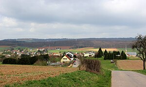
Saarwellingen
Municipality in Saarland, Germany
Distance: Approx. 7249 meters
Latitude and longitude: 49.35,6.83333333
Saarwellingen (German pronunciation: [ˌzaːɐ̯ˈvɛlɪŋən], French: Sarrevailingue) is a municipality in the district of Saarlouis in Saarland, Germany. As of 2022 it has a population of 13,302.

Heusweiler radio transmitter
Distance: Approx. 1439 meters
Latitude and longitude: 49.345,6.915
The Heusweiler transmitter was a facility for medium wave broadcasting north of Heusweiler, Germany. It originally went into service on 23 December 1935. On 19 June 1946 transmitter Heusweiler went in service again.

Transmitter Riegelsberg
Distance: Approx. 6592 meters
Latitude and longitude: 49.29129,6.92143
The Riegelsberg Transmitter (or Schocksberg Transmitter) is a transmitter for FM and TV at Riegelsberg, near Saarbrücken, Germany. The transmitter uses as aerial a 287-metre-high (942 ft) guyed mast.

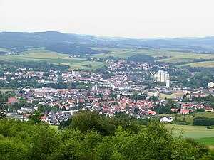
Heusweiler
Municipality in Saarland, Germany
Distance: Approx. 1206 meters
Latitude and longitude: 49.35,6.91666667
Heusweiler (German pronunciation: [hɔɪ̯sˈvaɪ̯lɐ]; Saarlandic: Heiswiller; older French: Hoysviller) is a municipality in the District of Saarbrücken, Saarland, Germany. It is situated approximately 13 km north of Saarbrücken. As of 2019, it has 18,062 inhabitants.

Eppelborn
Municipality in Saarland, Germany
Distance: Approx. 4429 meters
Latitude and longitude: 49.38333333,6.96666667
Eppelborn (Saarländisch: Ebbelborn or Ebbelborre) is a municipality in the district of Neunkirchen, in Saarland, Germany. The municipality encompasses 7 villages: Eppelborn, Wiesbach, Dirmingen, Humes, Habach, Hierscheid, Bubach-Calmeswieler und Macherbach. It is situated approximately 20 km north of Saarbrücken.

Illingen, Saarland
Municipality in Saarland, Germany
Distance: Approx. 7486 meters
Latitude and longitude: 49.36666667,7.03333333
Illingen is a municipality in the district of Neunkirchen, in Saarland, Germany. It is situated approximately 10 km northwest of Neunkirchen, and 17 km northeast of Saarbrücken.

Merchweiler
Municipality in Saarland, Germany
Distance: Approx. 7254 meters
Latitude and longitude: 49.35,7.03333333
Merchweiler is a municipality in the district of Neunkirchen, in Saarland, Germany. It is situated approximately 10 km west of Neunkirchen, and 15 km northeast of Saarbrücken. The municipality of Merchweiler consists of two parts: Merchweiler (village) and Wemmetsweiler (village).

Göttelborn Solar Park
Photovoltaic power station located in Göttelborn, in Quierschied municipality, Germany
Distance: Approx. 7486 meters
Latitude and longitude: 49.3393,7.0352
Gottelborn Solar Park (German: Solarpark Zeche Göttelborn) is an 8.4-MWp photovoltaic power station located in Göttelborn, in Quierschied municipality, Germany. The power plant was constructed by City Solar in two stages. The first stage was completed in August, 2004, followed by the second stage three years later in November 2007.
Paratrooper Battalion 261 (Bundeswehr)
Military unit
Distance: Approx. 6403 meters
Latitude and longitude: 49.40527778,6.90888889
The Paratrooper Battalion 261 (Fallschirmjägerbataillon 261) was one of the three combat battalions of the German Army's Airborne Brigade 26, which was a part of the Special Operations Division. Paratrooper Battalion 261 was fully airmobile and could act both as air assault infantry or be dropped by parachute into the area of operations.

Ill (Saarland)
River in Germany
Distance: Approx. 7225 meters
Latitude and longitude: 49.4149,6.9344
Ill is a river of Saarland, Germany. It flows through Eppelborn, and discharges into the Theel near Lebach.
Weather in this IP's area
clear sky
3 Celsius
-1 Celsius
2 Celsius
3 Celsius
1022 hPa
72 %
1022 hPa
985 hPa
10000 meters
4.63 m/s
60 degree