31.214.237.27 - IP Lookup: Free IP Address Lookup, Postal Code Lookup, IP Location Lookup, IP ASN, Public IP
Country:
Region:
City:
Location:
Time Zone:
Postal Code:
ISP:
ASN:
language:
User-Agent:
Proxy IP:
Blacklist:
IP information under different IP Channel
ip-api
Country
Region
City
ASN
Time Zone
ISP
Blacklist
Proxy
Latitude
Longitude
Postal
Route
db-ip
Country
Region
City
ASN
Time Zone
ISP
Blacklist
Proxy
Latitude
Longitude
Postal
Route
IPinfo
Country
Region
City
ASN
Time Zone
ISP
Blacklist
Proxy
Latitude
Longitude
Postal
Route
IP2Location
31.214.237.27Country
Region
new jersey
City
lyndhurst
Time Zone
America/New_York
ISP
Language
User-Agent
Latitude
Longitude
Postal
ipdata
Country
Region
City
ASN
Time Zone
ISP
Blacklist
Proxy
Latitude
Longitude
Postal
Route
Popular places and events near this IP address
Lyndhurst School District
School district in Bergen County, New Jersey, US
Distance: Approx. 253 meters
Latitude and longitude: 40.81001,-74.125582
The Lyndhurst School District is a comprehensive community public school district that serves students in pre-kindergarten through twelfth grade from Lyndhurst, in Bergen County, in the U.S. state of New Jersey. As of the 2021–22 school year, the district, comprising nine schools, had an enrollment of 2,540 students and 197.5 classroom teachers (on an FTE basis), for a student–teacher ratio of 12.9:1. The district is classified by the New Jersey Department of Education as being in District Factor Group "DE", the fifth-highest of eight groupings.
Lyndhurst High School
High school in Bergen County, New Jersey, US
Distance: Approx. 253 meters
Latitude and longitude: 40.810425,-74.126424
Lyndhurst High School is a four-year comprehensive public high school that serves students in ninth through twelfth grade from Lyndhurst, in Bergen County, in the U.S. state of New Jersey, operating as the lone secondary school of the Lyndhurst School District. As of the 2023–24 school year, the school had an enrollment of 835 students and 61.4 classroom teachers (on an FTE basis), for a student–teacher ratio of 13.6:1. There were 186 students (22.3% of enrollment) eligible for free lunch and 63 (7.5% of students) eligible for reduced-cost lunch.

Kingsland station
NJ Transit rail station
Distance: Approx. 646 meters
Latitude and longitude: 40.8101,-74.1172
Kingsland is a railroad station on New Jersey Transit's Main Line. It is located under Ridge Road (Route 17) between New York and Valley Brook Avenues in Lyndhurst, New Jersey, and is one of two stations in Lyndhurst. The station is not staffed, and passengers use ticket vending machines (TVMs) located at street level to purchase tickets.

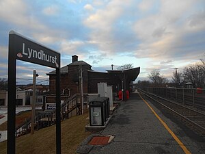
Lyndhurst station
NJ Transit rail station
Distance: Approx. 468 meters
Latitude and longitude: 40.8163,-74.1242
Lyndhurst is a New Jersey Transit rail station located off of New York Avenue in Lyndhurst, New Jersey. The station is one of two in Lyndhurst, the other being Kingsland station. The Lyndhurst station is located at milepost 8.2 on the Main Line.
Hillside Cemetery (Lyndhurst, New Jersey)
Distance: Approx. 1335 meters
Latitude and longitude: 40.81111111,-74.10861111
Hillside Cemetery is a non-profit, non-sectarian cemetery in Lyndhurst, New Jersey.

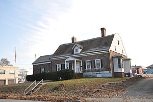
Jacob W. Van Winkle House
Historic house in New Jersey, United States
Distance: Approx. 833 meters
Latitude and longitude: 40.81638889,-74.1325
The Jacob W. Van Winkle House is located in Lyndhurst, Bergen County, in the U.S. state of New Jersey. The homestead was built in 1797 and is the current home of the Masonic Club of Lyndhurst. The homestead was added to the National Register of Historic Places on January 10, 1983.

River Road School
United States historic place
Distance: Approx. 851 meters
Latitude and longitude: 40.81472222,-74.13388889
The River Road School is located at 400 Riverside Avenue in the township of Lyndhurst in Bergen County, New Jersey, United States. The schoolhouse was built in 1893 and is the home of the Lyndhurst Historical Society. The schoolhouse was added to the National Register of Historic Places on November 11, 1977, for its significance in architecture and education.

Jeremiah J. Yeareance House
Historic house in New Jersey, United States
Distance: Approx. 951 meters
Latitude and longitude: 40.81555556,-74.13472222
The Jeremiah J. Yeareance House is located in Lyndhurst, Bergen County, New Jersey, United States. The house was built in 1804 and served as a residence for the teacher of River Road School. The house was added to the National Register of Historic Places on April 3, 1986.

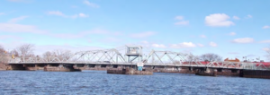
Lyndhurst Draw
Bridge in Clifton and Lyndhurst, New Jersey
Distance: Approx. 966 meters
Latitude and longitude: 40.8206,-74.1267
The Lyndhurst Draw is a railroad bridge crossing the Passaic River between Clifton and Lyndhurst in northeastern New Jersey. Built in 1903, it is owned and operated by New Jersey Transit Rail Operations (NJT). The swing bridge is situated between the Lyndhurst and Delawanna stations of NJT's Main Line, 8.52 miles (13.71 km) from its origination point at Hoboken Terminal, and 11.7 miles (18.8 km) from the river's mouth at Newark Bay.

Kingsland Avenue Bridge (Passaic River)
Bridge in Nutley and Lyndhurst, New Jersey
Distance: Approx. 1194 meters
Latitude and longitude: 40.811,-74.1385
Kingsland Avenue Bridge, earlier known as Avondale Bridge and designated the De Jessa Memorial Bridge, is a vehicular movable bridge over the Passaic River in northeastern New Jersey. It crosses the county line to connect the towns of Lyndhurst in Bergen and Nutley in Essex, originally taking its name from the Kingsland section. The bridge is 10.7 miles (17.2 km) from the river's mouth at Newark Bay, and is required to open on four hours' notice.
Kingsland, New Jersey
Populated place in Bergen County, New Jersey, US
Distance: Approx. 1288 meters
Latitude and longitude: 40.80638889,-74.11111111
Kingsland is an unincorporated community located within Lyndhurst Township in Bergen County, in the U.S. state of New Jersey. and the site of Kingsland station. The Kingsland Avenue Bridge is nearby.

Eighth Street Bridge (Passaic River)
Bridge in Passaic and Wallington, New Jersey
Distance: Approx. 966 meters
Latitude and longitude: 40.8206,-74.1267
Eighth Street Bridge is a road bridge over the Passaic River in northeastern New Jersey, United States. It connects the City of Passaic in Passaic County with the Borough of Wallington in Bergen County and is jointly owned by both counties. The bridge connects Eighth Street in Passaic with County Route 507 in Wallington.
Weather in this IP's area
clear sky
4 Celsius
-1 Celsius
3 Celsius
5 Celsius
1013 hPa
38 %
1013 hPa
1009 hPa
10000 meters
7.72 m/s
11.83 m/s
230 degree