31.209.158.83 - IP Lookup: Free IP Address Lookup, Postal Code Lookup, IP Location Lookup, IP ASN, Public IP
Country:
Region:
City:
Location:
Time Zone:
Postal Code:
ISP:
ASN:
language:
User-Agent:
Proxy IP:
Blacklist:
IP information under different IP Channel
ip-api
Country
Region
City
ASN
Time Zone
ISP
Blacklist
Proxy
Latitude
Longitude
Postal
Route
db-ip
Country
Region
City
ASN
Time Zone
ISP
Blacklist
Proxy
Latitude
Longitude
Postal
Route
IPinfo
Country
Region
City
ASN
Time Zone
ISP
Blacklist
Proxy
Latitude
Longitude
Postal
Route
IP2Location
31.209.158.83Country
Region
vesturland
City
borgarnes
Time Zone
Atlantic/Reykjavik
ISP
Language
User-Agent
Latitude
Longitude
Postal
ipdata
Country
Region
City
ASN
Time Zone
ISP
Blacklist
Proxy
Latitude
Longitude
Postal
Route
Popular places and events near this IP address

Borgarfjörður
Fjord in Iceland
Distance: Approx. 5964 meters
Latitude and longitude: 64.501,-22.01
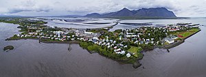
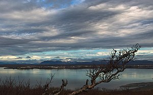
Borgarfjörður (Icelandic pronunciation: [ˈpɔrkarˌfjœrðʏr̥] ) is a fjord in the west of Iceland near the town of Borgarnes. Although the waters of Borgarfjörður appear calm, the fjord has significant undercurrents and shallows. The many flat islands lying in the fjord are for the most part uninhabited.

Borgarnes
Town in Northwest Constituency, Iceland
Distance: Approx. 584 meters
Latitude and longitude: 64.53333333,-21.91666667
Borgarnes (Icelandic pronunciation: [ˈpɔrkarˌnɛːs]) is a town located on a peninsula at the shore of Borgarfjörður in Iceland and is the largest town in the Borgarbyggð municipality with a population of about 3800 residents. It is a main junction in Iceland and the gateway to the Snaefellsnes National Park. Iceland's capital Reykjavík is 69 kilometers from the center of Borgarnes.

Western Region (Iceland)
Region of Iceland
Distance: Approx. 584 meters
Latitude and longitude: 64.53333333,-21.91666667
Western Region (Icelandic: Vesturland, Icelandic pronunciation: [ˈvɛstʏrˌlant] ) is one of the traditional eight regions of Iceland, located on the western coast of the island. As of 2024, the region has a population of 17,419.

Borgarbyggð
Municipality in Western Region, Iceland
Distance: Approx. 256 meters
Latitude and longitude: 64.54,-21.917
Borgarbyggð (Icelandic pronunciation: [ˈpɔrkarˌpɪɣθ] ) is a municipality in the west of Iceland. The biggest township in the municipality is Borgarnes, with a population of 1,887 inhabitants. Other densely populated areas in the municipality include Bifröst, Hvanneyri, Kleppjárnsreykir [ˈkʰlɛhpˌjaur̥sˌreiːcɪr̥], Reykholt and Varmaland.

Borg á Mýrum
Human settlement in Iceland
Distance: Approx. 2595 meters
Latitude and longitude: 64.5615,-21.9154
Borg (Icelandic pronunciation: [ˈpɔrk]) (often referred to as Borg á Mýrum) is a settlement due west of Borgarnes township in Iceland. Its recorded history reaches back to the settlement of Iceland. One of the country's original settlers was Skallagrímur Kveldúlfsson (Skalla-Grímr), who claimed the area around Borg as his land, built a farm and made his home there.

Agricultural University of Iceland
Education and Research institution from Iceland
Distance: Approx. 7651 meters
Latitude and longitude: 64.56111111,-21.76972222
The Agricultural University of Iceland (AUI) is an educational and research institution focusing on agricultural, environmental sciences, landscape architecture and planning founded in 2005. The university's main location is in Hvanneyri, near Borgarnes, Iceland, but it also operates research locations in Reykjavík (Kednaholt). AUI offers vocational training in agriculture, undergraduate and graduate studies in agricultural sciences, environmental sciences, equine sciences, forest sciences, landscape architecture, planning, restoration ecology and environmental changes at higher latitudes.

Borgarfjarðarbrú
Distance: Approx. 1444 meters
Latitude and longitude: 64.533663,-21.892426
Borgarfjarðarbrú (Icelandic pronunciation: [ˈpɔrkarˌfjarðarˌpruː], "Borgarfjörður bridge") is the second longest bridge in Iceland, after Skeiðarárbrú. It crosses Borgarfjörður, linking Borgarnes to Route 1 (the Ring Road) and connecting the town with other parts of Iceland. It spans 520 m and was opened on 13 September 1981, with repairs being done in 2012.

Hvanneyri
Distance: Approx. 8032 meters
Latitude and longitude: 64.562,-21.762
Hvanneyri (Icelandic pronunciation: [ˈkʰvanːˌeiːrɪ] ) is a small settlement in the municipality of Borgarbyggð in western Iceland. The settlement is an agricultural and church center known for its history of farming. Hvanneyri can be found 80 km north of Reykjavík.

Andakílsá
River in Vesturland, Iceland
Distance: Approx. 6711 meters
Latitude and longitude: 64.53527778,-21.78055556
Andakilsá (Icelandic pronunciation: [ˈantaˌcʰilsˌauː]) is a river in West Iceland (Vesturland). The river has its origin in Skorradalsvatn lake. Three small rivers flow from the direction of the Skarðsheiði mountain massif into Andakilsá on its way to the sea, the Borgarfjörður.
Weather in this IP's area
light snow
1 Celsius
1 Celsius
1 Celsius
1 Celsius
970 hPa
100 %
970 hPa
955 hPa
64 meters
1.26 m/s
1.96 m/s
120 degree
100 %