31.204.77.24 - IP Lookup: Free IP Address Lookup, Postal Code Lookup, IP Location Lookup, IP ASN, Public IP
Country:
Region:
City:
Location:
Time Zone:
Postal Code:
ISP:
ASN:
language:
User-Agent:
Proxy IP:
Blacklist:
IP information under different IP Channel
ip-api
Country
Region
City
ASN
Time Zone
ISP
Blacklist
Proxy
Latitude
Longitude
Postal
Route
db-ip
Country
Region
City
ASN
Time Zone
ISP
Blacklist
Proxy
Latitude
Longitude
Postal
Route
IPinfo
Country
Region
City
ASN
Time Zone
ISP
Blacklist
Proxy
Latitude
Longitude
Postal
Route
IP2Location
31.204.77.24Country
Region
viken
City
rodberg
Time Zone
Europe/Oslo
ISP
Language
User-Agent
Latitude
Longitude
Postal
ipdata
Country
Region
City
ASN
Time Zone
ISP
Blacklist
Proxy
Latitude
Longitude
Postal
Route
Popular places and events near this IP address

Nore og Uvdal
Municipality in Buskerud, Norway
Distance: Approx. 8996 meters
Latitude and longitude: 60.30722222,8.80555556
Nore og Uvdal is a municipality in Buskerud county, Norway. It is part of the traditional region of Numedal. The administrative centre of the municipality is the village of Rødberg.

Uvdal Stave Church
Church in Nore og Uvdal, Norway
Distance: Approx. 6215 meters
Latitude and longitude: 60.265,8.83472222
Uvdal Stave Church (Uvdal stavkirke) is situated at Uvdal in the valley Numedal in Nore og Uvdal in Buskerud, Norway. The stave church was originally constructed just after the year 1168, which is known through dendrochronological dating of the ore-pine used in the construction. The logs were not completely dry when the construction took place.

Rødberg
Village in Nore og Uvdal, Norway
Distance: Approx. 768 meters
Latitude and longitude: 60.26666667,8.93333333
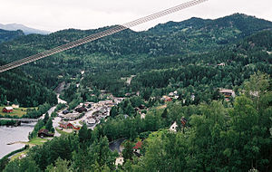
Rødberg is the administrative centre of Nore og Uvdal municipality in Buskerud, Norway. Rødberg is located in the Norwegian traditional district and valley of Numedal. Its population (2005) is 498, and it is located on the Rødberg dam (Norwegian: Rødbergdammen) on the Numedalslågen River.
Uvdal
Village and former municipality in Buskerud county, Norway
Distance: Approx. 6215 meters
Latitude and longitude: 60.265,8.83472222
Uvdal is a village and former municipality in Buskerud county, Norway. It is situated in the traditional region of Numedal and is the location of the Uvdal Stave Church. The municipality was created by a split from Nore on 1 January 1901.

Norefjorden
Lake in Norway
Distance: Approx. 8532 meters
Latitude and longitude: 60.19888889,9.01722222
Norefjorden is a lake in the municipality of Nore og Uvdal in Buskerud, Norway. Norefjorden is a long, narrow mountain lake which is known for its fishing. Numedalslågen flows into the far north and exits travelling southward to Kravikfjorden.
Nore Hydroelectric Power Station
Hydroelectric power station in Norway
Distance: Approx. 585 meters
Latitude and longitude: 60.2675,8.95777778
The Nore Power Station is a hydroelectric power station located in the municipality Nore og Uvdal in Buskerud, Norway. The oldest plant Nore I operates at an installed capacity of 206 MW, with an average annual production of 1,110 GWh. The plant Nore II has an installed capacity of 52 MW, with an average annual production of 314 GWh.
Weather in this IP's area
overcast clouds
-2 Celsius
-4 Celsius
-2 Celsius
-2 Celsius
991 hPa
97 %
991 hPa
882 hPa
313 meters
1.67 m/s
2.32 m/s
78 degree
100 %

