31.204.73.28 - IP Lookup: Free IP Address Lookup, Postal Code Lookup, IP Location Lookup, IP ASN, Public IP
Country:
Region:
City:
Location:
Time Zone:
Postal Code:
ISP:
ASN:
language:
User-Agent:
Proxy IP:
Blacklist:
IP information under different IP Channel
ip-api
Country
Region
City
ASN
Time Zone
ISP
Blacklist
Proxy
Latitude
Longitude
Postal
Route
db-ip
Country
Region
City
ASN
Time Zone
ISP
Blacklist
Proxy
Latitude
Longitude
Postal
Route
IPinfo
Country
Region
City
ASN
Time Zone
ISP
Blacklist
Proxy
Latitude
Longitude
Postal
Route
IP2Location
31.204.73.28Country
Region
viken
City
rollag
Time Zone
Europe/Oslo
ISP
Language
User-Agent
Latitude
Longitude
Postal
ipdata
Country
Region
City
ASN
Time Zone
ISP
Blacklist
Proxy
Latitude
Longitude
Postal
Route
Popular places and events near this IP address
Rollag
Municipality in Buskerud, Norway
Distance: Approx. 5053 meters
Latitude and longitude: 60.01722222,9.23388889
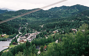
Rollag is a municipality in Buskerud county, Norway. It is part of the traditional region of Numedal. The administrative centre of the municipality is the village of Rollag, although the most populated area in the municipality is Veggli.

Numedal
District in Buskerud, Norway
Distance: Approx. 5644 meters
Latitude and longitude: 60,9.2
Numedal (Norwegian: [ˈnʉ̀ːmədɑːɫ]) is a valley and a traditional district in Eastern Norway located within the county of Buskerud. It traditionally includes the municipalities Flesberg, Nore og Uvdal and Rollag. Administratively, it now also includes Kongsberg.

Rollag Stave Church
Distance: Approx. 4187 meters
Latitude and longitude: 60.02027778,9.27444444
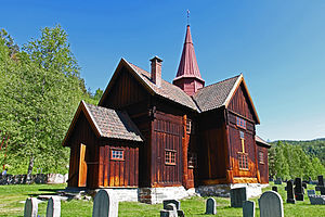
Rollag Stave Church (Norwegian: Rollag stavkyrkje) is a stave church in the municipality of Rollag in Buskerud county, Norway. The church is located a few kilometres north of the centre of the village of Rollag.
Weather in this IP's area
overcast clouds
-8 Celsius
-11 Celsius
-8 Celsius
-8 Celsius
1003 hPa
97 %
1003 hPa
930 hPa
7477 meters
1.65 m/s
1.79 m/s
255 degree
85 %
