Country:
 Turkey
Region:
City:
Latitude and Longitude:
Time Zone:
Postal Code:
IP information under different IP Channel
ip-api
Country
Region
City
ASN
Time Zone
ISP
Blacklist
Proxy
Latitude
Longitude
Postal
Route
IPinfo
Country
Region
City
ASN
Time Zone
ISP
Blacklist
Proxy
Latitude
Longitude
Postal
Route
MaxMind
Country
Region
City
ASN
Time Zone
ISP
Blacklist
Proxy
Latitude
Longitude
Postal
Route
Luminati
Country
TRRegion
06
City
ankara
ASN
Time Zone
Europe/Istanbul
ISP
Andromeda Tv Digital Platform Isletmeciligi A.s.
Latitude
Longitude
Postal
db-ip
Country
Region
City
ASN
Time Zone
ISP
Blacklist
Proxy
Latitude
Longitude
Postal
Route
ipdata
Country
Region
City
ASN
Time Zone
ISP
Blacklist
Proxy
Latitude
Longitude
Postal
Route
Popular places and events near this IP address

Ankara
Capital of Turkey
Distance: Approx. 582 meters
Latitude and longitude: 39.93,32.85
Ankara ( ANG-kər-ə, US also AHNG-kər-ə; Turkish: [ˈaŋkaɾa] ), historically known as Ancyra and Angora, is the capital of Turkey. Located in the central part of Anatolia, the city has a population of 5.1 million in its urban center and 5.8 million in Ankara Province, making it Turkey's second-largest city after Istanbul, but first by the urban area (4,130 km2). Serving as the capital of the ancient Celtic state of Galatia (280–64 BC), and later of the Roman province with the same name (25 BC–7th century), Ankara has various Hattian, Hittite, Lydian, Phrygian, Galatian, Greek, Persian, Roman, Byzantine, and Ottoman archeological sites.
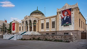
Ethnography Museum of Ankara
Distance: Approx. 514 meters
Latitude and longitude: 39.932668,32.854894
The Ethnography Museum of Ankara is dedicated to the cultures of Turkic civilizations. The building was designed by architect Arif Hikmet Koyunoğlu and was built between 1925 and 1928. The museum temporarily hosted the sarcophagus of Mustafa Kemal Atatürk from 1938 to 1953, during the period of the construction of Anıtkabir, his final resting place.
Council of State (Turkey)
Highest administrative court in Turkey
Distance: Approx. 428 meters
Latitude and longitude: 39.925,32.85361111
The Council of State (Turkish: Danıştay) is the highest administrative court in the Republic of Turkey and is located in Ankara. Its role and tasks are prescribed by the Constitution of Turkey within the articles on the supreme courts. According to Article 155 of the Turkish Constitution (1982), "The Council of State is the last instance for reviewing decisions and judgments given by administrative courts and not referred by law to other administrative courts.
125th Anniversary Çayyolu Stage
Distance: Approx. 847 meters
Latitude and longitude: 39.9208,32.8541
125th Anniversary Çayyolu Stage (Turkish: 125. Yıl Çayyolu Sahnesi), is a theatre in Çayyolu suburb of Çankaya district in Ankara, Turkey. It is operated by the Turkish State Theatres.

Hacettepe University Medical School
Distance: Approx. 668 meters
Latitude and longitude: 39.93164,32.86281
Hacettepe University Medical School is a medical school located at Hacettepe University Medical Center in Ankara, Turkey.
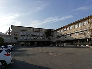
Ankara Atatürk High School
School in Çankaya, Ankara, Turkey
Distance: Approx. 447 meters
Latitude and longitude: 39.926757,32.851517
Ankara Atatürk High School (Turkish: Ankara Atatürk Lisesi), is an Anatolian High School located near Sıhhiye district of Çankaya, Ankara.

Gazi Mustafa Kemal Boulevard, Ankara
Distance: Approx. 821 meters
Latitude and longitude: 39.92333333,32.84916667
Gazi Mustafa Kemal Boulevard (Turkish: Gazi Mustafa Kemal Bulvarı), abbreviated as GMK Boulevard, is a boulevard connecting Anadolu Square (formerly: Tandoğan Square) in Yenimahalle with Kızılay Square in Çankaya of Ankara, Turkey. The 2.2 km (1.4 mi) long boulevard runs in northwest–southeast direction. It is named after Mustafa Kemal Atatürk (1881–1938), the founder of Turkish Republic.
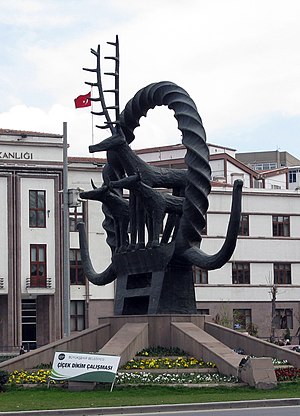
Hittite Sun Course Monument
Memorial in Sıhhiye Square, Ankara, Turkey
Distance: Approx. 359 meters
Latitude and longitude: 39.9255,32.8541
The Hittite Sun Disc Monument (Turkish: Hitit Güneş Kursu Anıtı) is a memorial dedicated to Hittites created by sculptor Nusret Suman and placed in Sıhhiye Square, Ankara, Turkey, in 1978.

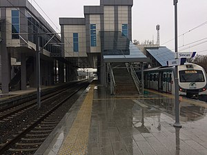
Yenişehir railway station
Distance: Approx. 142 meters
Latitude and longitude: 39.929,32.8551
Yenişehir railway station (Turkish: Yenişehir istasyonu) is a railway station on the Başkentray commuter rail line in Ankara, Turkey. The station is located a few blocks north of Kızılay Square, on the corner of Atatürk and Celal Bayar Boulevards and is the first station east of Ankara station, written as Gar on public transport maps. Yenişehir station was originally opened in 1972 with the inauguration of the Ankara suburban commuter service.
Kayaş railway station
Distance: Approx. 142 meters
Latitude and longitude: 39.929,32.8551
Kayaş railway station is a railway station on the Başkentray commuter rail line in Ankara, Turkey. Located in the Kayaş neighborhood of the Mamak district, it is the eastern terminus of the line. The station closed down in July 2016 and the platforms were demolished, expanded and rebuilt; Kayaş station reopened on 12 April 2018 and serves commuter, regional and intercity trains.
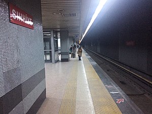
Sıhhiye (Ankara Metro)
Distance: Approx. 130 meters
Latitude and longitude: 39.928,32.8549
Sıhhiye is an underground station on the M1 line of the Ankara Metro in Çankaya, Ankara. The station is located beneath Atatürk Boulevard at its intersection with Celal Bayar Boulevard. Connection to TCDD Taşımacılık train service at Yenişehir is available.
TED University
University in Ankara, Turkey
Distance: Approx. 772 meters
Latitude and longitude: 39.9227,32.8619
TED University is a foundation university founded by the Turkish Education Association Higher Education Foundation on July 7, 2009. It started education in the 2012–2013 academic year with 320 students. The medium of instruction at TED University is English.
Weather in this IP's area
few clouds
25 Celsius
24 Celsius
24 Celsius
26 Celsius
1011 hPa
48 %
1011 hPa
917 hPa
10000 meters
2.57 m/s
20 %
06:23:18
19:09:27