31.192.210.236 - IP Lookup: Free IP Address Lookup, Postal Code Lookup, IP Location Lookup, IP ASN, Public IP
Country:
Region:
City:
Location:
Time Zone:
Postal Code:
IP information under different IP Channel
ip-api
Country
Region
City
ASN
Time Zone
ISP
Blacklist
Proxy
Latitude
Longitude
Postal
Route
Luminati
Country
Region
20
City
merkezefendi
ASN
Time Zone
Europe/Istanbul
ISP
Netinternet Bilisim Teknolojileri AS
Latitude
Longitude
Postal
IPinfo
Country
Region
City
ASN
Time Zone
ISP
Blacklist
Proxy
Latitude
Longitude
Postal
Route
IP2Location
31.192.210.236Country
Region
izmir
City
murat
Time Zone
Europe/Istanbul
ISP
Language
User-Agent
Latitude
Longitude
Postal
db-ip
Country
Region
City
ASN
Time Zone
ISP
Blacklist
Proxy
Latitude
Longitude
Postal
Route
ipdata
Country
Region
City
ASN
Time Zone
ISP
Blacklist
Proxy
Latitude
Longitude
Postal
Route
Popular places and events near this IP address

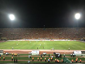
İzmir Atatürk Stadium
Multi-purpose stadium in İzmir, Turkey
Distance: Approx. 2185 meters
Latitude and longitude: 38.435,27.17805556
İzmir Atatürk Stadium (Turkish: İzmir Atatürk Stadyumu) is a multi-purpose stadium in İzmir, Turkey. It was named after the Turkish statesman Mustafa Kemal Atatürk. It is currently used mostly for football matches and occasionally for track and field events.
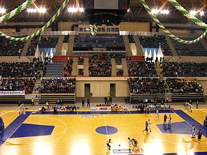
İzmir Halkapınar Sport Hall
Turkish indoor multi-purpose sports arena
Distance: Approx. 2287 meters
Latitude and longitude: 38.435,27.17361111
İzmir Halkapınar Sport Hall (Turkish: İzmir Halkapınar Spor Salonu) is an indoor multi-purpose sport venue that is located in the Halkapınar neighborhood of İzmir, Turkey. The hall has a seating capacity of 10,000 spectators.
Altındağ, İzmir
Distance: Approx. 2315 meters
Latitude and longitude: 38.4,27.2
Altındağ (Kokluca) is a densely populated zone (semt) of İzmir's Bornova district. The main intercity bus terminal of İzmir - IZOTAŞ is situated in Altındağ's Işıkkent quarter and is minutes away from Altındağ centre by walking. Altindag means "The Golden Mountain" in Turkish and the name is believed to have been given in reference to Greek soldiers and former inhabitants who buried their treasures in the mountain.
Buca Arena
Distance: Approx. 2469 meters
Latitude and longitude: 38.395,27.19277778
Buca Arena is a football stadium in İzmir and is located near to Yedigöller, north of Buca. Construction began in 2008; the opening ceremony of the new stadium was in 2009. The official capacity of Buca Arena is 8,810.
New İzmir Atatürk Stadium
Proposed multi-purpose stadium in İzmir, Turkey
Distance: Approx. 2173 meters
Latitude and longitude: 38.43486111,27.17786944
The New İzmir Atatürk Stadium is a proposed multi-purpose stadium in İzmir, Turkey that would replace the İzmir Atatürk Stadium.

Kemer railway station
Distance: Approx. 2446 meters
Latitude and longitude: 38.4219,27.1557
Kemer railway station (Turkish: Kemer İstasyonu) is a railway station in İzmir. The station is the oldest railway station in Turkey, built in 1857. İZBAN operates commuter trains north to Aliağa and Menemen and south to Cumaovası and Tepeköy.

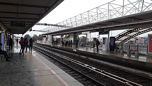
Hilal (İzmir Metro)
Distance: Approx. 2714 meters
Latitude and longitude: 38.4268,27.1549
Hilal is an elevated station on the M1 Line of the İzmir Metro in Konak. Located above the Turkish State Railways' Hilal junction, it is one of the ten original stations of the metro system. Connection to İZBAN commuter trains are available at Hilal railway station.

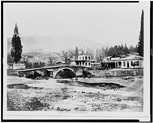
Caravan Bridge
Bridge built in ancient Greece
Distance: Approx. 2756 meters
Latitude and longitude: 38.422058,27.152059
Caravan Bridge (Turkish: Kervan Köprüsü) is an ancient bridge in the city of İzmir, Turkey. It was built in approximately 850 BC over the Meles river, and is one of the oldest man-made structures in continuous use. In antiquity, the River Meles was said to be the birthplace of Homer, and both the river and the bridge were featured in Homer's work.
Çınarlı railway station
Distance: Approx. 2813 meters
Latitude and longitude: 38.4399,27.1733
Çınarlı railway station was a station in İzmir, Turkey, abandoned in 2001. It was serviced by suburban trains from Basmane station to Çiğli. The station was located at a former grade crossing of 1561 Street, just northeast of Halkapınar station and consisted of two side platforms.

Altındağ (İzmir Metro)
Distance: Approx. 2343 meters
Latitude and longitude: 38.4294,27.203
Altındağ is a proposed underground station on the M5 Line of the İzmir Metro. It will be located beneath Kamil Tunca Avenue in the southern Bornova. Construction of the station, along with the metro line, is scheduled to begin in 2018.

Çamdibi (İzmir Metro)
Proposed rail station in İzmir, Turkey
Distance: Approx. 1974 meters
Latitude and longitude: 38.4324,27.1902
Çamdibi is a proposed underground station on the M5 Line of the İzmir Metro. It will be located beneath Kamil Tunca Avenue near the intersection with 5227th Street in the southwest Bornova. Construction of the station, along with the metro line, is scheduled to begin in 2018.

Vakıflar (İzmir Metro)
Proposed metro station for İzmir Metro
Distance: Approx. 1944 meters
Latitude and longitude: 38.433,27.1796
Vakıflar is a proposed underground station on the M5 Line of the İzmir Metro. It will be located beneath Şehitler Avenue near the intersection with Fatih Avenue just south of Atatürk Stadium. Construction of the station, along with the metro line, was scheduled to begin in 2018.
Weather in this IP's area
broken clouds
14 Celsius
14 Celsius
14 Celsius
14 Celsius
1024 hPa
82 %
1024 hPa
990 hPa
10000 meters
4.12 m/s
140 degree
75 %
