Country:
 Ireland
Region:
City:
Latitude and Longitude:
Time Zone:
Postal Code:
IP information under different IP Channel
ip-api
Country
Region
City
ASN
Time Zone
ISP
Blacklist
Proxy
Latitude
Longitude
Postal
Route
IPinfo
Country
Region
City
ASN
Time Zone
ISP
Blacklist
Proxy
Latitude
Longitude
Postal
Route
MaxMind
Country
Region
City
ASN
Time Zone
ISP
Blacklist
Proxy
Latitude
Longitude
Postal
Route
Luminati
Country
IERegion
l
City
dublin
ASN
Time Zone
Europe/Dublin
ISP
Liberty Global B.V.
Latitude
Longitude
Postal
db-ip
Country
Region
City
ASN
Time Zone
ISP
Blacklist
Proxy
Latitude
Longitude
Postal
Route
ipdata
Country
Region
City
ASN
Time Zone
ISP
Blacklist
Proxy
Latitude
Longitude
Postal
Route
Popular places and events near this IP address

Dublin Port Tunnel
Road traffic tunnel in Dublin, Ireland
Distance: Approx. 682 meters
Latitude and longitude: 53.36118,-6.2341
The Dublin Tunnel (Irish: Tollán Bhaile Átha Cliath), originally and still commonly known as the Port Tunnel, is a road traffic tunnel in Dublin, Ireland, that forms part of the M50 motorway. The twin tunnels form a two-lane dual carriageway connecting Dublin Port, which lies to the east of central Dublin, and the M50 motorway at junction 2, close to Dublin Airport. The tunnels are 4.5 km (2.8 mi) in length and total project length of 5.6 km (3.5 mi).
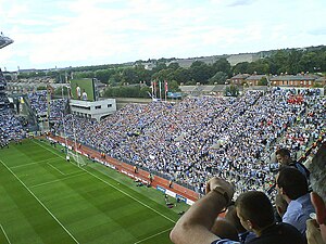
Hill 16
Terrace at Croke Park, Dublin, Ireland
Distance: Approx. 458 meters
Latitude and longitude: 53.36146,-6.250288
Hill 16 – officially called Dineen Hill 16 and sometimes referred to as The Hill – is a terrace at the Railway End of Croke Park, the principal stadium and headquarters of the Gaelic Athletic Association (GAA). It is located on the Northside of the Irish capital city, Dublin.

North Strand
Northern residential district of Dublin, Ireland
Distance: Approx. 570 meters
Latitude and longitude: 53.3582,-6.2409
North Strand (Irish: An Trá Thuaidh ) is a residential inner city neighbourhood on the Northside of Dublin, Ireland.
St. Vincent's Hospital, Fairview
Psychiatric hospital in Dublin, Ireland
Distance: Approx. 410 meters
Latitude and longitude: 53.366685,-6.24399
St. Vincent's Hospital, Fairview (Irish: Ospidéal Naomh Uinseann, Fionnradharc) is a small psychiatric hospital in Fairview, Dublin, Ireland.

North Strand Road
Street in Dublin, Ireland
Distance: Approx. 527 meters
Latitude and longitude: 53.358525,-6.241297
North Strand Road (Irish: Bóthar na Trá Thuaidh) is a street in the Northside of Dublin, Ireland. It links the city centre from Connolly Station to Fairview by road.
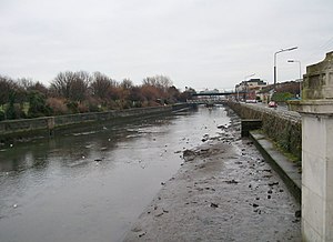
Annesley Bridge
Bridge in Dublin
Distance: Approx. 307 meters
Latitude and longitude: 53.3609,-6.2409
Annesley Bridge (Irish: Droichead Annesley) crosses the River Tolka in Fairview, Dublin, Ireland. It is named after Richard Annesley, 6th Earl of Anglesey. The East Wall Road, North Strand Road and Poplar Row meet at the west end of the bridge with Annesley Bridge Road at the east end, making it an important junction in the north inner city.
O'Connell School
School in Ireland
Distance: Approx. 652 meters
Latitude and longitude: 53.3593,-6.2515
The O’Connell School is a secondary and primary school for boys located on North Richmond Street in Dublin, Ireland. The school, named in honour of the leader of Catholic Emancipation, Daniel O’Connell, has the distinction of being the oldest surviving Christian Brothers school in Dublin, having been first established in 1829. It is now under the trusteeship of the Edmund Rice Schools Trust.
2009 All-Ireland Senior Football Championship final
Football match
Distance: Approx. 549 meters
Latitude and longitude: 53.36072222,-6.25122222
The 2009 All-Ireland Football Championship final was the 122nd event of its kind. Played between Cork and Kerry on 20 September 2009 in Croke Park, Dublin, it was the last football match of the 2009 All-Ireland Senior Football Championship. Kerry won by a score of 0–16 to 1–09.

Ballybough Cemetery
Jewish cemetery in Dublin, Ireland
Distance: Approx. 176 meters
Latitude and longitude: 53.3625,-6.24138889
Ballybough Cemetery (Irish: Reilig an Bhaile Bhoicht) is a Jewish cemetery in Ballybough, Dublin. Founded in 1718, it is Ireland's oldest Jewish cemetery.
GAA Hall of Fame
Distance: Approx. 457 meters
Latitude and longitude: 53.3607,-6.2496
The GAA Hall of Fame is the hall of fame for Gaelic games in Ireland. The hall opened in the Cusack Stand, Croke Park, Dublin, on 11 February 2013, with 32 inaugural inductees.

Jones Road Distillery
Irish distillery
Distance: Approx. 296 meters
Latitude and longitude: 53.363205,-6.24834289
The Dublin Whiskey Distillery Company Jones Road Distillery also known as the D.W.D. Distillery, Jones Road, or just Jones Road Distillery, was one of the six great Irish whiskey distilleries of Dublin city visited and documented by Alfred Barnard in his seminal 1887 publication "The Whisky Distilleries of the United Kingdom". It was located on the north side of the city on the banks of the river Tolka, approximately a mile north of the city centre. The distillery was built by the Dublin Whiskey Distillery Company Ltd and the Irish whiskey produced sold around the world under the brand name D.W.D. Construction began on 22 July 1872, under the supervision of founder John Brannick, and exactly one year later on the 22 July 1873, D.W.D.'s first mash was produced.

North Strand Church (Church of Ireland)
Church in Dublin
Distance: Approx. 511 meters
Latitude and longitude: 53.3584946,-6.2424395
North Strand Church, is a Church of Ireland church on North Strand and Waterloo Avenue, in Dublin. The original church was established in 1786. It is now part of the United Parish of Drumcondra, North Strand, and Saint Barnabas.
Weather in this IP's area
light intensity shower rain
14 Celsius
14 Celsius
13 Celsius
15 Celsius
991 hPa
91 %
991 hPa
990 hPa
10000 meters
4.12 m/s
110 degree
75 %
07:37:37
18:47:31