Country:
Region:
City:
Latitude and Longitude:
Time Zone:
Postal Code:
IP information under different IP Channel
ip-api
Country
Region
City
ASN
Time Zone
ISP
Blacklist
Proxy
Latitude
Longitude
Postal
Route
Luminati
Country
Region
gb
City
bishkek
ASN
Time Zone
Asia/Bishkek
ISP
AKNET Ltd.
Latitude
Longitude
Postal
IPinfo
Country
Region
City
ASN
Time Zone
ISP
Blacklist
Proxy
Latitude
Longitude
Postal
Route
db-ip
Country
Region
City
ASN
Time Zone
ISP
Blacklist
Proxy
Latitude
Longitude
Postal
Route
ipdata
Country
Region
City
ASN
Time Zone
ISP
Blacklist
Proxy
Latitude
Longitude
Postal
Route
Popular places and events near this IP address

White House, Bishkek
Presidential office building in Bishkek, Kyrgyzstan
Distance: Approx. 1027 meters
Latitude and longitude: 42.87729167,74.60015
The White House is the presidential office building in Bishkek, Kyrgyzstan. The White House was the site of riots during both the 2005 Tulip Revolution and the 2010 Kyrgyzstani riots. During the 2010 riots a fire broke out and damaged portions of the building and destroyed the hard copies of many government records.
Dolen Omurzakov Stadium
Sports venue in Bishkek, Kyrgyzstan
Distance: Approx. 1239 meters
Latitude and longitude: 42.880175,74.59793889
The Dolen Omurzakov Stadium is a multi-purpose stadium in Bishkek, Kyrgyzstan. It is currently used mostly for football matches. The stadium holds 23,000 and is currently the home ground of the Kyrgyzstan national football team, Dordoi Bishkek and Alga Bishkek.

National Bank of the Kyrgyz Republic
Central Bank of Kyrgyzstan
Distance: Approx. 1198 meters
Latitude and longitude: 42.8758,74.5812
The National Bank of the Kyrgyz Republic (Kyrgyz: Кыргыз Республикасынын Улуттук Банкы, romanized: Kyrgyz Respublikasynyn Uluttuk Banky) is the central bank of Kyrgyzstan and is primarily responsible for the strategic monetary policy planning of the country as well as the issuance of the national currency, the Som.

Kirghiz Soviet Socialist Republic
Constituent Union republic of the Soviet Union (1936-1991)
Distance: Approx. 644 meters
Latitude and longitude: 42.86666667,74.6
The Kirghiz Soviet Socialist Republic (Kirghiz SSR), also known as the Kyrgyz Soviet Socialist Republic (Kyrgyz SSR), KySSR or Kirgiz Soviet Socialist Republic (Kirgiz SSR), was one of the constituent republics of the Soviet Union (USSR) from 1936 to 1991. It was also known by the names Kyrgyzstan and Soviet Kyrgyzstan in the Kyrgyz language, and as Kirghizia and Soviet Kirghizia in the Russian language. Landlocked and mountainous, it bordered Tajikistan and China to the south, Uzbekistan to the west and Kazakhstan to the north.

Ala-Too Square
Central square in Bishkek, Kyrgyzstan
Distance: Approx. 1154 meters
Latitude and longitude: 42.87638889,74.60388889
Ala-Too Square is the central square in Bishkek, Kyrgyzstan.

International University of Kyrgyzstan
Distance: Approx. 1077 meters
Latitude and longitude: 42.877451,74.585494
The International University of Kyrgyzstan (Kyrgyz: Кыргызстан эл аралык университети, Russian: Международный университет Кыргызстана) is a state international university in Bishkek, the capital of Kyrgyzstan. The university was established by decree of the President of the Kyrgyz Republic, Askar Akayev, № UP-74, on March 11, 1993, and by the enactment of the Government of Kyrgyzstan, № 113, on March 16, 1993. The founders of the International University of Kyrgyzstan are the Government of Kyrgyzstan, the Ministry of Education and Sciences of the Kyrgyz Republic, the Ministry of Foreign Affairs of the Kyrgyz Republic, the National Academy of Sciences of the Kyrgyz Republic and San Francisco State University in the United States.
Panfilov Street, Bishkek
Street in Bishkek, Kyrgyzstan
Distance: Approx. 631 meters
Latitude and longitude: 42.871,74.6007
Panfilov Street (Kyrgyz: Панфилов көчөсү, romanized: Panfilov köchösü; Russian: улица Панфилова) is a street in Bishkek, Kyrgyzstan. It stretches from Abdylas Maldybaev Street in the south to Jibek Jolu Prospekti in the north. The street was named after Soviet general Ivan Panfilov in 1941.

Kyrgyz Economic University
Distance: Approx. 1355 meters
Latitude and longitude: 42.8816,74.596
The Kyrgyz Economic University (Кыргызский экономический университет), is a Kyrgyz public university located in Bishkek. Specializing in economics and international relations, it is one of the best universities in Kyrgyzstan and one of the best in Central Asia in economics. It was founded in 1953.
List of ambassadors of China to Kyrgyzstan
Distance: Approx. 635 meters
Latitude and longitude: 42.872743,74.586709
The Chinese Ambassador to Kyrgyzstan is the official representative of the People's Republic of China to the Kyrgyz Republic.

Panfilov Park (Bishkek)
Distance: Approx. 1251 meters
Latitude and longitude: 42.8796,74.6002
Panfilov Park (Kyrgyz: Панфилов паркы, romanized: Panfilov parkı; Russian: Парк Панфилова) is an urban park located near Old Square and Manas Square in Bishkek, the capital of the Kyrgyz Republic. The park bears the name of Hero of the Soviet Union, and the chairman of the Military Committee of the Kirghiz SSR, Ivan Panfilov. The park was made in the shape of a star when it was built.

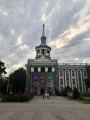
Kyrgyz National Philharmonic
Concert hall in Bishkek, Kyrgyzstan
Distance: Approx. 1074 meters
Latitude and longitude: 42.8783,74.5875
The Toktogul Satylganov Kyrgyz National Philharmonic is a landmark building in Bishkek, Kyrgyzstan and home to musical performances. It is named after Kyrgyz aqyn Toktogul Satylganov.

Kyrgyz State Historical Museum
Distance: Approx. 1249 meters
Latitude and longitude: 42.8777,74.6038
The Kyrgyz State History Museum (Kyrgyz: Кыргыз Мамлекеттик Тарых музейи; Russian: Кыргызский государственный исторический музей) is a museum located in Bishkek, Kyrgyzstan. The museum contains literally thousands of exhibits about the cultural heritage of the Kyrgyz people, whose sculptures and objects date from antiquity to the end of the 20th century. It is one of the most important museums in Central Asia.
Weather in this IP's area
overcast clouds
10 Celsius
9 Celsius
10 Celsius
10 Celsius
1020 hPa
76 %
1020 hPa
932 hPa
10000 meters
4.32 m/s
7.59 m/s
291 degree
100 %
07:41:02
17:49:24