Country:
Region:
City:
Latitude and Longitude:
Time Zone:
Postal Code:
IP information under different IP Channel
ip-api
Country
Region
City
ASN
Time Zone
ISP
Blacklist
Proxy
Latitude
Longitude
Postal
Route
Luminati
Country
Region
14
City
warsaw
ASN
Time Zone
Europe/Warsaw
ISP
Liberty Global B.V.
Latitude
Longitude
Postal
IPinfo
Country
Region
City
ASN
Time Zone
ISP
Blacklist
Proxy
Latitude
Longitude
Postal
Route
db-ip
Country
Region
City
ASN
Time Zone
ISP
Blacklist
Proxy
Latitude
Longitude
Postal
Route
ipdata
Country
Region
City
ASN
Time Zone
ISP
Blacklist
Proxy
Latitude
Longitude
Postal
Route
Popular places and events near this IP address
Ząbki
Place in Masovian Voivodeship, Poland
Distance: Approx. 2411 meters
Latitude and longitude: 52.29277778,21.11611111
Ząbki [ˈzɔmpki] is a town in central Poland with 31,884 inhabitants (2013). It is situated in the Masovian Voivodeship, just northeast of Warsaw.

Targówek
Warsaw District in Masovian Voivodeship, Poland
Distance: Approx. 1605 meters
Latitude and longitude: 52.28222222,21.06416667
Targówek (Polish pronunciation: [tarˈɡuvɛk] ) is a district in Warsaw, Poland located in the northern part of the city. It is divided into two parts: residential and industrial. About 30% of the district's area is covered by municipal parks, such as Lasek Bródnowski, Park Bródnowski and Park Wiecha in the eastern part of the district.

Horowe Bagno Nature Reserve
Nature reserve in Marki, Poland
Distance: Approx. 1557 meters
Latitude and longitude: 52.3,21.1
Horowe Bagno is a peat nature reserve in Marki near Warsaw in Poland. The area of the reserve is 43,82 ha.
Targówek (shopping centre)
Shopping mall in Warsaw, Poland
Distance: Approx. 2002 meters
Latitude and longitude: 52.30333333,21.05722222
Targówek Shopping Center is a shopping center in Warsaw, at ul. Głębocka 15, in the district of Targówek. It has over 140 Polish and international shops and restaurants as well as a Multikino 12 screen cinema.

Targówek Mieszkaniowy metro station
Warsaw metro station
Distance: Approx. 3246 meters
Latitude and longitude: 52.2695,21.0514
Targówek Mieszkaniowy is a Warsaw Metro station in Warsaw's Targówek district. It is part of the extension of Line M2 from Dworzec Wileński to Targówek, with construction started in 2016. All three stations opened on September 15, 2019.

Trocka metro station
Warsaw metro station
Distance: Approx. 2576 meters
Latitude and longitude: 52.2753,21.0554
Trocka is a Warsaw Metro station in Warsaw's Targówek district. It is part of the extension of Line M2 from Dworzec Wileński to Targówek, with construction started in 2016. All three stations opened on September 15, 2019.
Ząbki Municipal Stadium
Distance: Approx. 1557 meters
Latitude and longitude: 52.3,21.1
The Ząbki Municipal Stadium (Polish: Stadion Miejski w Ząbkach), officially since 2018 called Dozbud Arena for sponsorship reasons., and Dolcan Arena in the past; is a multi-use stadium in Ząbki, Poland. It is currently used mostly for football matches and is the home ground of Ząbkovia Ząbki. The stadium holds 2,100 people and was extensively rebuilt to its current look in 2012.
International Sailing Schools Association
Non-profit international association
Distance: Approx. 1665 meters
Latitude and longitude: 52.283631,21.061004
The International Sailing Schools Association also known as ISSA is an international organization associating 3,500 sailing schools from all over the world. ISSA was founded in London and Paris in 1969 as a result of a joint initiative of the sailing communities of France, Poland, Italy, Switzerland and Great Britain. In 1982, the Parliamentary Assembly of the Council of Europe granted the ISSA consultative status as an NGO. In 2005 World Sailing discussed the role of ISSA at its annual conference.

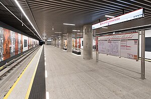
Kondratowicza metro station
Metro station in Warsaw, Poland
Distance: Approx. 2270 meters
Latitude and longitude: 52.29211111,21.04736111
Kondratowicza is a station on the north-eastern part of Line M2 (Warsaw Metro). It is located in the vicinity of Ludwika Kondratowicza, Malborska, 20 Dywizji Piechoty Wojska Polskiego and Aleksandra Kowalskiego streets. The station is located by the Masovian Bródno District Hospital (Mazowiecki Szpital Bródnowski).

Warszawa Zacisze Wilno railway station
Railway stop in Warsaw, Poland
Distance: Approx. 1640 meters
Latitude and longitude: 52.27777778,21.08
Warszawa Zacisze Wilno railway station is a railway station in the Targówek district of Warsaw, Poland. As of 2022, it is used by Koleje Mazowieckie, which runs services to Warszawa Wileńska and Czyżew.

Bródno Park
Urban park in Warsaw, Poland
Distance: Approx. 3025 meters
Latitude and longitude: 52.29055556,21.03638889
The Bródno Park (Polish: Park Bródnowski) is an urban park in Warsaw, Poland. It is located in the neighbourhood of Bródno within the district of Targówek, between Kondratowicza Street, Chodecka Street, Wyszogrodzka Street; and Łabiszyńska Street. It was opened in 1978.
Wiech Park
Urban park in Warsaw, Poland
Distance: Approx. 2993 meters
Latitude and longitude: 52.27277778,21.05083333
The Stefan Wiechecki "Wiech" Park, also simply known as the Wiech Park, is an urban park in Warsaw, Poland, located in the district of Targówek, between Kołowa, Remiszewska, Ossowskiego, and Handlowa Streets. It was opened in 1963.
Weather in this IP's area
overcast clouds
3 Celsius
-1 Celsius
2 Celsius
4 Celsius
1031 hPa
86 %
1031 hPa
1020 hPa
7000 meters
4.47 m/s
140 degree
100 %
06:48:11
15:51:10

