31.177.55.171 - IP Lookup: Free IP Address Lookup, Postal Code Lookup, IP Location Lookup, IP ASN, Public IP
Country:
Region:
City:
Location:
Time Zone:
Postal Code:
ISP:
ASN:
language:
User-Agent:
Proxy IP:
Blacklist:
IP information under different IP Channel
ip-api
Country
Region
City
ASN
Time Zone
ISP
Blacklist
Proxy
Latitude
Longitude
Postal
Route
db-ip
Country
Region
City
ASN
Time Zone
ISP
Blacklist
Proxy
Latitude
Longitude
Postal
Route
IPinfo
Country
Region
City
ASN
Time Zone
ISP
Blacklist
Proxy
Latitude
Longitude
Postal
Route
IP2Location
31.177.55.171Country
Region
la rioja
City
banos de rio tobia
Time Zone
ISP
Language
User-Agent
Latitude
Longitude
Postal
ipdata
Country
Region
City
ASN
Time Zone
ISP
Blacklist
Proxy
Latitude
Longitude
Postal
Route
Popular places and events near this IP address

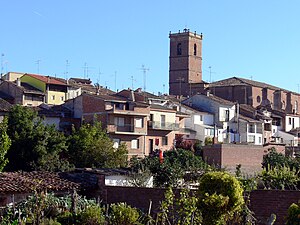
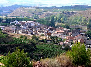
Baños de Río Tobía
Municipality in La Rioja, Spain
Distance: Approx. 36 meters
Latitude and longitude: 42.335,-2.76083333
Baños de Río Tobía is a village of La Rioja, in Spain. Located near the Najerilla river, in 2021 it had a population of 1,583 inhabitants. Its Chorizo, wood and plywood industry is notable.

Arenzana de Abajo
Municipality in La Rioja, Spain
Distance: Approx. 6659 meters
Latitude and longitude: 42.38638889,-2.71888889
Arenzana de Abajo is a village in the province and autonomous community of La Rioja, Spain. The municipality covers an area of 8.39 square kilometres (3.24 sq mi) and as of 2011 had a population of 274 people.

Badarán
Municipality in La Rioja, Spain
Distance: Approx. 5200 meters
Latitude and longitude: 42.36694444,-2.8075
Badarán is a village in the province and autonomous community of La Rioja, Spain. The municipality covers an area of 20.69 square kilometres (7.99 sq mi) and as of 2011 had a population of 595 people.
Camprovín
Municipality in La Rioja, Spain
Distance: Approx. 3784 meters
Latitude and longitude: 42.35388889,-2.7225
Camprovín is a village in the province and autonomous community of La Rioja, Spain. The municipality covers an area of 20.45 square kilometres (7.90 sq mi) and as of 2011 had a population of 178 people.

Cárdenas, La Rioja
Municipality in La Rioja, Spain
Distance: Approx. 4357 meters
Latitude and longitude: 42.37416667,-2.76722222
Cárdenas is a village in the province and autonomous community of La Rioja, Spain. The municipality covers an area of 3.98 square kilometres (1.54 sq mi) and as of 2011 had a population of 182 people.

Cordovín
Municipality in La Rioja, Spain
Distance: Approx. 7028 meters
Latitude and longitude: 42.38472222,-2.81416667
Cordovín is a village in the province and autonomous community of La Rioja, Spain. The municipality covers an area of 4.6 square kilometres (1.8 sq mi) and as of 2011 had a population of 189 people.

Ledesma de la Cogolla
Municipality in La Rioja, Spain
Distance: Approx. 3937 meters
Latitude and longitude: 42.31972222,-2.71805556
Ledesma de la Cogolla is a village in the province and autonomous community of La Rioja, Spain. The municipality covers an area of 12.13 square kilometres (4.68 sq mi) and as of 2011 had a population of 22 people.

Matute
Municipality in La Rioja, Spain
Distance: Approx. 4951 meters
Latitude and longitude: 42.29861111,-2.795
Matute is a village in the province and autonomous community of La Rioja, Spain. The municipality covers an area of 25.65 square kilometres (9.90 sq mi) and as of 2011 had a population of 142 people.

Tobía
Municipality in La Rioja, Spain
Distance: Approx. 6095 meters
Latitude and longitude: 42.29805556,-2.81527778
Tobía (Spanish pronunciation: [toˈβi.a]) is a village in the province and autonomous community of La Rioja, Spain. The municipality covers an area of 34.94 square kilometres (13.49 sq mi) and as of 2011 had a population of 72 people.

Villaverde de Rioja
Municipality in La Rioja, Spain
Distance: Approx. 4674 meters
Latitude and longitude: 42.32,-2.81388889
Villaverde de Rioja is a village in the province and autonomous community of La Rioja, Spain. The municipality covers an area of 5.87 square kilometres (2.27 sq mi) and as of 2011 had a population of 72 people.

Bobadilla, La Rioja
Municipality in La Rioja, Spain
Distance: Approx. 1987 meters
Latitude and longitude: 42.3175,-2.75916667
Bobadilla is a municipality in the Province of La Rioja, Spain.

Comarca de Nájera
Comarca in Spain
Distance: Approx. 6236 meters
Latitude and longitude: 42.391167,-2.7555
Nájera is a comarca in La Rioja province in Spain.
Weather in this IP's area
light rain
11 Celsius
10 Celsius
11 Celsius
11 Celsius
1005 hPa
79 %
1005 hPa
900 hPa
10000 meters
4.22 m/s
12.46 m/s
258 degree
