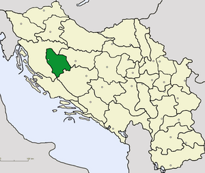
Country:
 Bosnia & Herzegovina
Region:
City:
Latitude and Longitude:
Time Zone:
Postal Code:
IP information under different IP Channel
ip-api
Country
Region
City
ASN
Time Zone
ISP
Blacklist
Proxy
Latitude
Longitude
Postal
Route
IPinfo
Country
Region
City
ASN
Time Zone
ISP
Blacklist
Proxy
Latitude
Longitude
Postal
Route
MaxMind
Country
Region
City
ASN
Time Zone
ISP
Blacklist
Proxy
Latitude
Longitude
Postal
Route
Luminati
Country
BARegion
bih
City
sanskimost
ASN
Time Zone
Europe/Sarajevo
ISP
BH Telecom d.d. Sarajevo
Latitude
Longitude
Postal
db-ip
Country
Region
City
ASN
Time Zone
ISP
Blacklist
Proxy
Latitude
Longitude
Postal
Route
ipdata
Country
Region
City
ASN
Time Zone
ISP
Blacklist
Proxy
Latitude
Longitude
Postal
Route
Popular places and events near this IP address

Bihać
City in Federation of Bosnia and Herzegovina, Bosnia and Herzegovina
Distance: Approx. 450 meters
Latitude and longitude: 44.81666667,15.86666667
Bihać is a city and the administrative centre of Una-Sana Canton of the Federation of Bosnia and Herzegovina, an entity of Bosnia and Herzegovina. It is situated on the banks of river Una in northwestern Bosnia and Herzegovina, in the Bosanska Krajina region. In 2013 its population was 56,261.
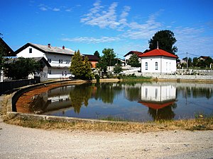
Jezero, Bihać
Village in Bosnia and Herzegovina
Distance: Approx. 1402 meters
Latitude and longitude: 44.80555556,15.87361111
Jezero (Serbian Cyrillic: Језеро) is a village in the municipality of Bihać, Bosnia and Herzegovina.

Bihać Republic
Yugoslav territory liberated from the Nazis
Distance: Approx. 450 meters
Latitude and longitude: 44.81666667,15.86666667
The Bihać Republic (Serbo-Croatian Latin: Bihaćka Republika, Cyrillic: Бихаћка Република) was a short-lived republic that existed between November 1942 and January 1943 in a liberated area of Nazi-occupied Yugoslavia. It was established by the Partisan resistance movement following the liberation of Bihać. Bihać became its administrative center and the first session of the Anti-Fascist Council of the People's Liberation of Yugoslavia (AVNOJ) was held there on 26 November 1942.

Siege of Bihać (1992–1995)
Three-year-long siege of the northwestern Bosnian town of Bihać during the Bosnian War
Distance: Approx. 450 meters
Latitude and longitude: 44.81666667,15.86666667
The siege of Bihać was a three-year-long siege of the northwestern Bosnian town of Bihać by the Army of the Republika Srpska, the Army of the Republic of Serbian Krajina and Bosnian Muslim dissenters led by Fikret Abdić during the 1992–95 Bosnian War. The siege lasted for three years, from June 1992 until 4–5 August 1995, when Operation Storm ended it after the Croatian Army (HV) overran the rebel Serbs in Croatia and northwest of the besieged town. The Research and Documentation Center in Sarajevo established that the communities that were under siege – Bihać, Bosanska Krupa, Cazin and Velika Kladuša – had 4,856 killed or missing persons from 1991 to 1995.

Fethija Mosque (Bihać)
Mosque in Bihać, Bosnia and Herzegovina
Distance: Approx. 549 meters
Latitude and longitude: 44.8134,15.8699
Fethija Mosque (Bosnian: Fethija džamija) is a mosque and former Catholic church located in the town of Bihać, Bosnia and Herzegovina. Built in 1266, it is the oldest gothic building in the country. It was originally built as a Catholic church dedicated to Saint Anthony of Padua, and was subsequently transformed into a mosque following the 1592 conquest of Bihać from Habsburg Croatia by the Ottoman Empire.
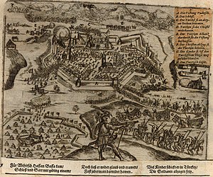
Siege of Bihać (1592)
Distance: Approx. 450 meters
Latitude and longitude: 44.816667,15.866667
The siege of Bihać (Croatian: Opsada Bihaća) was the besieging and capture of the city of Bihać, Kingdom of Croatia within Habsburg monarchy, by the Ottoman Empire in June 1592. With the arrival of Hasan-paša Predojević as the Beylerbey of the Bosnia Eyalet in 1591, a period of peace established between Emperor Rudolf II and Sultan Murad III ended and the provincial Ottoman armies launched an offensive on Croatia. Bihać, a nearly isolated city on the Una River that repelled an Ottoman attack in 1585, was one of the first targets.
Radio Bihać
Bosnian radio station
Distance: Approx. 450 meters
Latitude and longitude: 44.81666667,15.86666667
Radio Bihać is a Bosnian local public radio station, broadcasting from Bihać, Bosnia and Herzegovina. Radio Bihać was launched on 28 March 1966 by the municipal council of Bihać. In Yugoslavia and in SR Bosnia and Herzegovina, it was part of local/municipal Radio Sarajevo network affiliate.
Novi Radio Bihać
Bosnian radio station
Distance: Approx. 450 meters
Latitude and longitude: 44.81666667,15.86666667
Novi Radio Bihać or Novi Radio is a Bosnian local commercial radio station, broadcasting from Bihać, Bosnia and Herzegovina. Formatted as contemporary hit radio, this radio station broadcasts a variety of programs such as music, short local news and morning talk shows. Program is mainly produced in Bosnian language and it was intended for the local audience in Bihać and Cazin area.

Bihać operation
A military operation
Distance: Approx. 450 meters
Latitude and longitude: 44.81666667,15.86666667
The Bihać operation was a military operation conducted by Yugoslav partisans against the Independent State of Croatia (NDH) and Nazi Germany during World War II. The aim of the operation was to capture Bihać and the surrounding towns to connect Partisan held areas in Bosanska Krajina, and Knisnka Krajina. The battle for the city of Bihać lasted from 2 November to 4 November 1942. After capturing the city, the partisans continued to fight in surrounding areas until 15 November.
Radio Unsko-sanskog kantona
Bosnian radio station
Distance: Approx. 450 meters
Latitude and longitude: 44.81666667,15.86666667
Radio Unsko-sanskog kantona or Radio USK is a Bosnian local public radio station, broadcasting from Bihać, Bosnia and Herzegovina and it broadcasts a variety of programs such as news, music, morning and talk shows. Program is operated by RTV USK and it is mainly produced in Bosnian language. Radio Unsko-sanskog kantona was launched on 15 August 1996 as regional (Canton) public radio station in Una-Sana Canton.
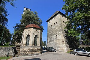
Turbe Mausoleum (Bihać)
Islamic burial site in Bosnia and Herzegovina
Distance: Approx. 482 meters
Latitude and longitude: 44.81397,15.87018
Turbe Mauzolej (transl. Turbe Mausoleum), is a turbe (a kind of Islamic mausoleum) in Bihać, Bosnia and Herzegovina, which originates from the period of Austro-Hungarian rule in Bosnia and Herzegovina and was built to show reverence for the defenders of the city who died in the fight against Austro-Hungarian troops in 1878.
Bihać Oblast
Former oblast of Yugoslavia
Distance: Approx. 450 meters
Latitude and longitude: 44.81666667,15.86666667
Bihać Oblast (Serbo-Croatian: Бихаћка област, romanized: Bihaćka Oblast) was one of the oblasts of the Kingdom of Serbs, Croats and Slovenes from 1922 to 1929. Its administrative center was Bihać.
Weather in this IP's area
overcast clouds
12 Celsius
11 Celsius
12 Celsius
12 Celsius
1018 hPa
99 %
1018 hPa
991 hPa
1410 meters
1.49 m/s
2.46 m/s
7 degree
99 %
06:40:18
19:00:15