31.148.20.16 - IP Lookup: Free IP Address Lookup, Postal Code Lookup, IP Location Lookup, IP ASN, Public IP
Country:
Region:
City:
Location:
Time Zone:
Postal Code:
IP information under different IP Channel
ip-api
Country
Region
City
ASN
Time Zone
ISP
Blacklist
Proxy
Latitude
Longitude
Postal
Route
Luminati
Country
Region
26
City
krykhivtsi
ASN
Time Zone
Europe/Kyiv
ISP
Online Business Technologies Ltd.
Latitude
Longitude
Postal
IPinfo
Country
Region
City
ASN
Time Zone
ISP
Blacklist
Proxy
Latitude
Longitude
Postal
Route
IP2Location
31.148.20.16Country
Region
ivano-frankivska oblast
City
ivano-frankivsk
Time Zone
Europe/Kiev
ISP
Language
User-Agent
Latitude
Longitude
Postal
db-ip
Country
Region
City
ASN
Time Zone
ISP
Blacklist
Proxy
Latitude
Longitude
Postal
Route
ipdata
Country
Region
City
ASN
Time Zone
ISP
Blacklist
Proxy
Latitude
Longitude
Postal
Route
Popular places and events near this IP address

Ivano-Frankivsk
City in Ivano-Frankivsk Oblast, Ukraine
Distance: Approx. 166 meters
Latitude and longitude: 48.92277778,24.71055556
Ivano-Frankivsk (Ukrainian: Івано-Франківськ, IPA: [iˈwɑno frɐnˈkiu̯sʲk] ), formerly Stanyslaviv, Stanislav and Stanisławów, is a city in western Ukraine. It serves as the administrative centre of Ivano-Frankivsk Oblast as well as Ivano-Frankivsk Raion within the oblast. Ivano-Frankivsk also hosts the administration of the Ivano-Frankivsk urban hromada.

Stanisławów Voivodeship
Former voivodeship of Poland
Distance: Approx. 223 meters
Latitude and longitude: 48.923379,24.710144
Stanisławów Voivodeship (Polish: Województwo stanisławowskie) was an administrative district of the interwar Poland (1920–1939). It was established in December 1920 with an administrative center in Stanisławów. The voivodeship had an area of 16,900 km2 and comprised twelve counties (powiaty).

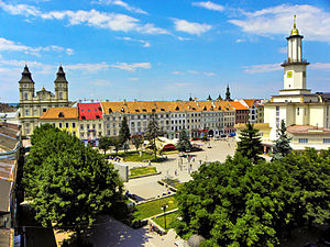
Market Square, Ivano-Frankivsk
Distance: Approx. 124 meters
Latitude and longitude: 48.922479,24.710118
Market Square in Ivano-Frankivsk is called Ploshcha Rynok (Ukrainian: Площа Ринок) and is historically the central square of the city. It is the oldest square and traces its history to the city's establishment. The main feature of the square is the former city hall, Ratusha, which today serves as the building of the Museum of regional studies.

Ivano-Frankivsk Regional Art Museum
Art museum in Ivano-Frankivsk
Distance: Approx. 249 meters
Latitude and longitude: 48.92361111,24.70916667
The Art Museum of Prykarpattia (Ukrainian: Музей мистецтв Прикрапаття), originally the Ivano-Frankivsk Regional Art Museum (until 2012) is a regional art museum located at 8 Maidan Andrey Sheptytskyi, Ivano-Frankivsk, Ukraine, in the former Church of Virgin Mary. It has one of the best collections of local religious art, and specializes in displaying works by local artists.

Hrushevsky Street (Ivano-Frankivsk)
Distance: Approx. 306 meters
Latitude and longitude: 48.92138889,24.71388889
Mykhailo Hrushevsky Street (Ukrainian: Вулиця Грушевського) is one of the most important streets located in Ivano-Frankivsk. It runs along several government institutions such as regional and city administration Bily Dim as well as the city's branch of the National Bank of Ukraine.

Ivano-Frankivsk Municipality
Former subdivision of Ivano-Frankivsk Oblast, Ukraine
Distance: Approx. 160 meters
Latitude and longitude: 48.9225,24.71111111
Ivano-Frankivsk Municipality is a former administrative subdivision of Ivano-Frankivsk Oblast located within the Tysmenytsia Raion and completely surrounded by that raion. It consisted of the city of Ivano-Frankivsk, the administrative center of the oblast, and a number of rural localities. Population: 263,359 (2020 est.).

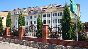
Ivano-Frankivsk National Medical University
Public university in Ivano-Frankivsk, Ukraine
Distance: Approx. 69 meters
Latitude and longitude: 48.9216,24.7088
Ivano-Frankivsk National Medical University (Ukrainian: Івано-Франківський національний медичний університет) is an institute of higher medical education in Ivano-Frankivsk, Ukraine. The university is an accredited Higher Education institution and provides medical education from undergraduate to postgraduate level. The university history started in 1945 and is listed in the WHO Directory of Medical Schools and in the US FAIMER International Medical Education Directory (IMED).
King Danylo University
University in Ivano-Frankivsk, Ukraine
Distance: Approx. 689 meters
Latitude and longitude: 48.91527778,24.71111111
The King Danylo University is a university in Prykarpattia Ukraine .
West Ukrainian University of Economics and Law
Ukrainian University
Distance: Approx. 214 meters
Latitude and longitude: 48.92194444,24.7125
West Ukrainian University of Economics and Law is a Ukrainian University in Ivano-Frankivsk.

Sheptytsky Square
Distance: Approx. 194 meters
Latitude and longitude: 48.92305556,24.70888889
Sheptytsky Square (Ukrainian: Майдан Шептицького, romanized: Maidan Sheptytskoho) is a square in the old town of Ivano-Frankivsk, commemorated to the head of Ukrainian Greek Catholic Church, Metropolitan Archbishop Lviv Andrey Sheptytsky who initially served in the town as bishop. The square is located in the center of the town, directly adjacent to the Market Square separated from it by a row of private multi-story apartment buildings. The northern end of the square faces the Roman Catholic collegiate church of the Blessed Virgin Mary building which at the moment contains an art museum.

Stanisławów Ghetto
Nazi ghetto in occupied Ukraine
Distance: Approx. 166 meters
Latitude and longitude: 48.92277778,24.71055556
Stanisławów Ghetto (Polish: getto w Stanisławowie, German: Ghetto Stanislau) was a ghetto established in 1941 by Nazi Germany in Stanisławów (now Ivano-Frankivsk) in German occupied Poland (today Ukraine). After the German invasion of the Soviet Union, the town was incorporated into District of Galicia, as the fifth district of the General Government. On 12 October 1941, during the so-called Bloody Sunday, some 10,000–12,000 Jews were shot into mass graves at the Jewish cemetery by the German uniformed SS-men from SIPO and Order Police battalions assisted by the Ukrainian Auxiliary Police.

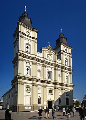
Cathedral of the Resurrection of Christ, Ivano-Frankivsk
Church in Ivano-Frankivsk, Ukraine
Distance: Approx. 593 meters
Latitude and longitude: 48.926,24.7056
The Cathedral of the Resurrection of Christ or of Our Saviour (Ukrainian: Собор Святого Воскресіння), also called the Ivano-Frankivsk Jesuit Church, is an historic religious building in the city of Ivano-Frankivsk in western Ukraine which functions as a Catholic cathedral and seat of the Ivano-Frankivsk Eparchy (Archieparchia Stanislaopolitanus) using the Byzantine or Ukrainian rite (Greek Catholic) in full communion with the Pope in Rome. The original church on the site was built for the Jesuits between 1720 and 1729, but this structure was demolished as a result of technical errors. The present Baroque church was built between 1752 and 1761 by the ruler of the city, the governor of Poznan and Kiev Stanisław Potocki.
Weather in this IP's area
few clouds
0 Celsius
0 Celsius
0 Celsius
0 Celsius
1027 hPa
90 %
1027 hPa
995 hPa
10000 meters
0.97 m/s
0.96 m/s
215 degree
21 %

