Country:
 Iraq
IraqRegion:
City:
Latitude and Longitude:
Time Zone:
Postal Code:
IP information under different IP Channel
ip-api
Country
Region
City
ASN
Time Zone
ISP
Blacklist
Proxy
Latitude
Longitude
Postal
Route
IPinfo
Country
Region
City
ASN
Time Zone
ISP
Blacklist
Proxy
Latitude
Longitude
Postal
Route
MaxMind
Country
Region
City
ASN
Time Zone
ISP
Blacklist
Proxy
Latitude
Longitude
Postal
Route
Luminati
Country
IQRegion
ar
City
erbil
ASN
Time Zone
Asia/Baghdad
ISP
DIL Technology Limited
Latitude
Longitude
Postal
db-ip
Country
Region
City
ASN
Time Zone
ISP
Blacklist
Proxy
Latitude
Longitude
Postal
Route
ipdata
Country
Region
City
ASN
Time Zone
ISP
Blacklist
Proxy
Latitude
Longitude
Postal
Route
Popular places and events near this IP address
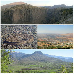
Erbil Governorate
Governorate of the Kurdistan Region, Iraq
Distance: Approx. 2052 meters
Latitude and longitude: 36.18333333,44.03333333
Erbil Governorate (Kurdish: پارێزگای ھەولێر ,Parêzgeha Hewlêr, Arabic: محافظة أربيل, romanized: Muḥāfaẓat Arbīl) is a governorate in the Kurdistan Region. It is the capital and economic hub of the semi-autonomous Kurdistan Region of Iraq.

Franso Hariri Stadium
Stadium in Erbil, Kurdistan Region, Iraq
Distance: Approx. 1149 meters
Latitude and longitude: 36.1725,44.01138889
Franso Hariri Stadium (Kurdish: یاریگای فرانسۆ ھەریری, Yarîgay Franso Herîrî; Arabic: ملعب فرانسوا حريري) is a multi-purpose stadium in Erbil, Kurdistan Region, Iraq. It is currently used mostly for football matches by Erbil SC who plays in the Iraqi Premier League. The stadium also has facilities for athletics.

Qaysari Bazaar
Distance: Approx. 635 meters
Latitude and longitude: 36.18847,44.0097
A Qaysari bazaar is a type of covered bazaar typical of Kurdistan and Iraq. Arbil (Kurdish: Hawler) contains an extensive Qaysari, just south of the citadel in the center of town that was first established in the early 13th century AD. The Qaysari is entered through the numerous alleys that surround it. Once inside, shoppers walk through a maze of narrow paths between the shops, underneath a roof of corrugated metal.
University of Kurdistan Hewler
Semiprivate University in Erbil, Kurdistan Region
Distance: Approx. 401 meters
Latitude and longitude: 36.1812,44.0065
The University of Kurdistan Hewlêr (UKH) is an educational institution in Erbil/Hewlêr, the Kurdistan Region of Iraq. UKH is a public university that was established in 2006. The University Of Kurdistan Hewler obtained top ranking throughout the Region in 2018.

Mudhafaria Minaret
Distance: Approx. 1116 meters
Latitude and longitude: 36.1876,43.9996
The Mudhafaria Minaret is a minaret located in the new Minare Park on the west region of Erbil, Kurdistan Region, Iraq. The minaret is 36 m (118 ft) high, was built in 1190–1232 AD (586–630 AH) by the Turcoman prince of Erbil, in the reign of Saladin, Muzaffar Al-Din Abu Sa’eed Al-Kawkaboori (Gökböri) who had entered in the obedience of Saladin without war and married his sister. The minaret is composed of a high octagonal base and a tall cylindrical shaft, with a balcony located between the base and the shaft.

Erbil
Capital of Kurdistan, Iraq
Distance: Approx. 941 meters
Latitude and longitude: 36.191188,44.009189
Erbil (Arabic: أربيل, Arbīl; Syriac: ܐܲܪܒܹܝܠ, Arbel), also called Hawler (Kurdish: هەولێر, Hewlêr), is the capital and most populated city in the Kurdistan Region of Iraq. The city is in the Erbil Governorate. Human settlement at Erbil may be dated back to the 5th millennium BC. At the heart of the city is the ancient Citadel of Erbil and Mudhafaria Minaret.
Nanakaly Hospital for Hematology & Oncology
Hospital in Kurdistan region, Iraq
Distance: Approx. 2074 meters
Latitude and longitude: 36.16416667,44.01055556
Nanakaly Hospital for Hematology & Oncology is a government hospital located near No Shahed Martyr mosque, in Azady, Hawler, Kurdistan region, Iraq. It treats patients with blood disease, leukemia, and hemophilia. It was built by Ahmad Ismail Nanakaly and opened on 16 May 2004.

Chaldean Catholic Archeparchy of Arbil
Eastern Catholic archeparchy in Kurdistan, Iraq
Distance: Approx. 945 meters
Latitude and longitude: 36.1833,44
The Chaldean Catholic Archdiocese of Erbil (Latin: Archieparchia Arbilensis Chaldaeorum, Arabic: إيبارشية أربيل الكلدانية) is a Chaldean Catholic diocese with its seat in Erbil, Kurdistan Region. Erected in 1968 with territory taken from the Archeparchy of Kirkuk, it is immediately subject to the Patriarchal See of Babylon. The see of the archbishop is the Cathedral of St.

Erbil Civilization Museum
Archaeological museum in Kurdistan Region, Iraq
Distance: Approx. 650 meters
Latitude and longitude: 36.17739444,44.01324722
The Erbil Civilization Museum (Kurdish: مۆزەخانەی شارستانیی ھەولێر, Arabic: متحف أربيل الحضاري) is an archeological museum which is located within the city of Hawler, the capital of Iraqi Kurdistan. It is the second largest museum in Iraqi Kurdistan, after the Sulaymaniyah Museum in Sulaymaniyah Governorate in terms of contents and collections. It houses artifacts which date back to the pre-historic period to the late Abbasid period.

E1 Tower
Skyscrapter in the Kurdistan Region, Iraq
Distance: Approx. 977 meters
Latitude and longitude: 36.17477778,44.00608333
The Erbil 1 Tower, also known as Zaniary Tower, is a 48-story, 180 m (591 ft) tall multi-use skyscraper in the heart of Erbil, capital of the Kurdistan Region of Iraq. The E1 Tower is the tallest building in the country. The project was part of Kirmanj Construction Company owned by Eng.

Erbil Stones and Gems Museum
Museum in Iraqi Kurdistan
Distance: Approx. 828 meters
Latitude and longitude: 36.19018,44.00932
Erbil Stones and Gems Museum is a small museum located within the Citadel of Erbil, at the heart of the city of Erbil (Hawler), the capital of Iraqi Kurdistan.
Turkmen Culture House
Museum in Erbil, Iraq
Distance: Approx. 853 meters
Latitude and longitude: 36.19035,44.0089
The Turkmen Culture House (Turkish: Türkmen Kültür Evi; Arabic: بيت التراث التركماني) is an exhibition located within the Citadel of Erbil, in the center of Erbil, northern Iraq. It was officially inaugurated on September 5, 2021. The exhibition aims to preserve and display the culture and history of the Iraqi Turkmen, who are the third largest nationality of Iraq.
Weather in this IP's area
clear sky
28 Celsius
27 Celsius
28 Celsius
28 Celsius
1007 hPa
28 %
1007 hPa
962 hPa
8000 meters
1.54 m/s
220 degree
05:41:14
18:22:18