Country:
 Russian Federation
Region:
City:
Latitude and Longitude:
Time Zone:
Postal Code:
IP information under different IP Channel
ip-api
Country
Region
City
ASN
Time Zone
ISP
Blacklist
Proxy
Latitude
Longitude
Postal
Route
IPinfo
Country
Region
City
ASN
Time Zone
ISP
Blacklist
Proxy
Latitude
Longitude
Postal
Route
MaxMind
Country
Region
City
ASN
Time Zone
ISP
Blacklist
Proxy
Latitude
Longitude
Postal
Route
Luminati
Country
RURegion
amu
City
blagoveshchensk
ASN
Time Zone
Asia/Yakutsk
ISP
Limited Liability Company TTK-Svyaz
Latitude
Longitude
Postal
db-ip
Country
Region
City
ASN
Time Zone
ISP
Blacklist
Proxy
Latitude
Longitude
Postal
Route
ipdata
Country
Region
City
ASN
Time Zone
ISP
Blacklist
Proxy
Latitude
Longitude
Postal
Route
Popular places and events near this IP address

Zeya (river)
River in Amur Oblast, Russia
Distance: Approx. 6649 meters
Latitude and longitude: 50.2419,127.598
The Zeya (Russian: Зе́я; from indigenous Evenki word "djee" (blade); Chinese: 结雅; Manchu: ᠵᡳᠩᡴᡳᡵᡳ ᠪᡳᡵᠠ, Mölendroff: jingkiri bira) is a northern, left tributary of the Amur in Amur Oblast, Russia. It is 1,242 km (772 mi) long, and has a drainage basin of 233,000 km2 (90,000 sq mi). The average flow of the river is 1,810 m3/s (64,000 cu ft/s).

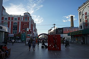
Blagoveshchensk
City in Amur Oblast, Russia
Distance: Approx. 3659 meters
Latitude and longitude: 50.25,127.53333333
Blagoveshchensk (Russian: Благовещенск, IPA: [bləɡɐˈvʲeɕːɪnsk], lit. 'City of the Annunciation') is a city and the administrative center of Amur Oblast, Russia. It is located at the confluence of the Amur and the Zeya Rivers, opposite to the Chinese city of Heihe. Population: 241,437 (2021 Census); 214,390 (2010 Census); 219,221 (2002 Census); 205,553 (1989 Soviet census).The Amur has formed Russia's border with China since the 1858 Aigun Treaty and the 1860 Treaty of Peking.

Heihe
Prefecture-level city in China
Distance: Approx. 4795 meters
Latitude and longitude: 50.2401,127.521
Heihe (Chinese: 黑河; pinyin: Hēihé; lit. 'Black River'; Russian: Хэйхэ) is a prefecture-level city of northern Heilongjiang province, China, located on the Russian border, on the south bank of the Amur (Heilong) River, across the river from Blagoveshchensk. At the 2020 census, 1,286,401 people lived in the prefecture-level city of whom 223,832 lived in the built-up area (or metro) made of Aihui District. Heihe marks the northeast terminus of the diagonal Heihe–Tengchong Line, which is sometimes used to divide China into east and west.
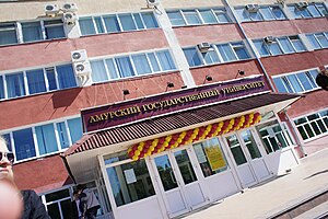
Amur State University
Building
Distance: Approx. 916 meters
Latitude and longitude: 50.275,127.534
Amur State University (Russian: Аму́рский госуда́рственный университе́т) is a university in Blagoveshchensk, Amur Oblast, Russia. Blagoveshchensk Technological Institute was founded on the basis of Blagoveshchensk Technical Faculty in 1975. In 1992 Blagoveshchensk Technological Institute was renamed into Blagoveshchensk Polytechnical Institute.

Blagoveshchensk State Pedagogical University
Building
Distance: Approx. 3659 meters
Latitude and longitude: 50.25,127.533333
Blagoveschensk State Pedagogical University (BSPU) is located in Blagoveschensk, the administrative center of the Amur Oblast. The city of Blagoveschensk was founded in 1856 and is one of the most important administrative, cultural, scientific, and industrial centers of the Russian Far East region; with more than 220,000 inhabitants. Blagoveschensk is often called “The Gate to China” for its unique location on the border with China.
Aihui District
District in Heilongjiang, China
Distance: Approx. 5321 meters
Latitude and longitude: 50.24111111,127.49333333
Aihui District (simplified Chinese: 爱辉区; traditional Chinese: 愛輝區; pinyin: Àihuī Qū) is an administrative district and the seat of the prefecture-level city of Heihe, Heilongjiang Province, China. It is located on the right (south-western) bank of the Amur River, across which is Blagoveshchensk, Amur Oblast, Russia. Aihui District spans an area of 1,443 km2 (557 sq mi), and had a population of 192,764 as of 2000.

Blagoveshchensky District, Amur Oblast
District in Amur Oblast, Russia
Distance: Approx. 3886 meters
Latitude and longitude: 50.31666667,127.51666667
Blagoveshchensky District (Russian: Благове́щенский райо́н) is an administrative and municipal district (raion), one of the twenty in Amur Oblast, Russia. The area of the district is 3,060 square kilometers (1,180 sq mi). Its administrative center is the city of Blagoveshchensk (which is not administratively a part of the district).

Far Eastern Higher Combined Arms Command School
Military academy of the Russian Armed Forces
Distance: Approx. 3053 meters
Latitude and longitude: 50.25888889,127.50888889
The Marshal of the Soviet Union K. K. Rokossovsky Far Eastern Higher Combined Arms Command School (Russian: Дальневосточное высшее общевойсковое командное училище имени Маршала Советского Союза К. К. Рокоссовского), also known by its abbreviation DVOKU (Russian: ДВОКУ), is a military academy of the Russian Armed Forces. Established on 11 February 1940 as the Vladivostok Infantry School, the Far Eastern Higher Combined Arms Command School is one of the oldest military educational establishments in Russia. Opening shortly before the Axis invasion of the Soviet Union, it went on to train infantry company and platoon commanders during the war.
Weather in this IP's area
clear sky
0 Celsius
-7 Celsius
0 Celsius
0 Celsius
1028 hPa
25 %
1028 hPa
1011 hPa
10000 meters
10 m/s
320 degree
06:58:20
17:31:02