31.11.208.88 - IP Lookup: Free IP Address Lookup, Postal Code Lookup, IP Location Lookup, IP ASN, Public IP
Country:
Region:
City:
Location:
Time Zone:
Postal Code:
ISP:
ASN:
language:
User-Agent:
Proxy IP:
Blacklist:
IP information under different IP Channel
ip-api
Country
Region
City
ASN
Time Zone
ISP
Blacklist
Proxy
Latitude
Longitude
Postal
Route
db-ip
Country
Region
City
ASN
Time Zone
ISP
Blacklist
Proxy
Latitude
Longitude
Postal
Route
IPinfo
Country
Region
City
ASN
Time Zone
ISP
Blacklist
Proxy
Latitude
Longitude
Postal
Route
IP2Location
31.11.208.88Country
Region
dolnoslaskie
City
klodzko
Time Zone
Europe/Warsaw
ISP
Language
User-Agent
Latitude
Longitude
Postal
ipdata
Country
Region
City
ASN
Time Zone
ISP
Blacklist
Proxy
Latitude
Longitude
Postal
Route
Popular places and events near this IP address

Kłodzko
Place in Lower Silesian Voivodeship, Poland
Distance: Approx. 614 meters
Latitude and longitude: 50.43861111,16.655
Kłodzko ([ˈkwɔt͡skɔ] ; Czech: Kladsko; German: Glatz; Latin: Glacio) is a historic town in south-western Poland, in the region of Lower Silesia. It is situated in the centre of the Kłodzko Valley, on the Eastern Neisse (Nysa Kłodzka) river. Kłodzko is the seat of Kłodzko County (and of the rural Gmina Kłodzko, although the town itself is a separate urban gmina), and is situated in Lower Silesian Voivodeship.

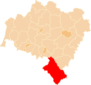
Kłodzko County
County in Lower Silesian Voivodeship, Poland
Distance: Approx. 690 meters
Latitude and longitude: 50.43777778,16.65277778
Kłodzko County (Polish: powiat kłodzki) is a unit of territorial administration and local government (powiat) in Lower Silesian Voivodeship, south-western Poland. It came into being on 1 January 1999 as a result of the Polish local government reforms passed in 1998. The county covers an area of 1,643 square kilometres (634 sq mi); its territory almost exactly corresponds to the former Bohemian, later Prussian, County of Kladsko.

Church of the Assumption, Kłodzko
Church in Kłodzko, Poland
Distance: Approx. 690 meters
Latitude and longitude: 50.43777778,16.65277778
The Collegiate Church of the Assumption of the Blessed Virgin Mary (Polish: Kolegiata Wniebowzięcia Najświętszej Maryi Panny w Kłodzku) is a Gothic collegiate church in Kłodzko, Poland, one of the landmarks of its Old Town. It was constructed from the fourteenth through the sixteenth centuries, and houses the remains of Arnošt of Pardubice, the first Archbishop of Prague. The church possesses rich historical decorations and furnishings, including a Gothic vault, portal, baptismal font, Gothic and Renaissance sculptures and Baroque altars, confessionals and organs.
Gmina Kłodzko
Gmina in Lower Silesian Voivodeship, Poland
Distance: Approx. 690 meters
Latitude and longitude: 50.43777778,16.65277778
Gmina Kłodzko is a rural gmina (administrative district) in Kłodzko County, Lower Silesian Voivodeship, in south-western Poland. Its seat is the town of Kłodzko, although the town is not part of the territory of the gmina. The gmina covers an area of 252.25 square kilometres (97.4 sq mi), and as of 2019 its total population is 17,142.

Boguszyn, Lower Silesian Voivodeship
Village in Lower Silesian Voivodeship, Poland
Distance: Approx. 3400 meters
Latitude and longitude: 50.46305556,16.68
Boguszyn [bɔˈɡuʂɨn] is a village in the administrative district of Gmina Kłodzko, within Kłodzko County, Lower Silesian Voivodeship, in south-western Poland. The settlement is part of historic Kłodzko Land. It lies in the eastern Kłodzko Valley at the foot of the Bardzkie Mountains, approximately 4 kilometres (2 mi) north-east of Kłodzko, and 78 kilometres (48 mi) south of the regional capital Wrocław.
Jaszkowa Dolna
Village in Lower Silesian Voivodeship, Poland
Distance: Approx. 1565 meters
Latitude and longitude: 50.43333333,16.68333333
Jaszkowa Dolna [jaʂˈkɔva ˈdɔlna] is a village in the administrative district of Gmina Kłodzko, within Kłodzko County, Lower Silesian Voivodeship, in south-western Poland. It lies approximately 3 kilometres (2 mi) east of Kłodzko, and 81 kilometres (50 mi) south of the regional capital Wrocław.
Jaszkówka
Village in Lower Silesian Voivodeship, Poland
Distance: Approx. 2609 meters
Latitude and longitude: 50.43694444,16.69805556
Jaszkówka [jaʂˈkufka] is a village in the administrative district of Gmina Kłodzko, within Kłodzko County, Lower Silesian Voivodeship, in south-western Poland. Prior to 1945 it was in Germany. It lies approximately 4 kilometres (2 mi) east of Kłodzko, and 81 kilometres (50 mi) south of the regional capital Wrocław.

Mikowice, Lower Silesian Voivodeship
Village in Lower Silesian Voivodeship, Poland
Distance: Approx. 4015 meters
Latitude and longitude: 50.44416667,16.60666667
Mikowice [mikɔˈvit͡sɛ] is a village in the administrative district of Gmina Kłodzko, within Kłodzko County, Lower Silesian Voivodeship, in south-western Poland. It lies approximately 4 kilometres (2 mi) west of Kłodzko and 82 km (51 mi) south of the regional capital Wrocław.
Kłodzko Fortress
Fortress in Poland
Distance: Approx. 934 meters
Latitude and longitude: 50.44138889,16.65305556
Kłodzko Fortress (Polish: Twierdza Kłodzko, German: Festung Glatz) is a unique fortification complex of the Lower Silesian Voivodeship in southwestern Poland. The fortress once was one of the biggest strongholds in Prussian Silesia, however, in the whole German Empire, it was regarded as a minor one. Now, together with an extensive network of tunnels, it is one of the biggest attractions of the town of Kłodzko, with its underground labyrinth and a repository of different objects, from old fire engines to local glassware.
Siege of Glatz
Siege during Third Silesian War
Distance: Approx. 827 meters
Latitude and longitude: 50.433333,16.65
The siege of Glatz took place in 1760 during the Third Silesian War (part of the Seven Years' War) when an Austrian force led by General von Laudon laid siege to and successfully stormed the fortress of Glatz (Czech: Kladsko, Polish: Kłodzko) from its Prussian garrison. On 6 June Laudon surrounded Glatz, but he had to wait until heavy artillery was brought from Olmütz (Olomouc) in neighbouring Moravia. While waiting, Laudon received information about the approach of a Prussian force under Fouqué.

Kłodzko Synagogue
Former Reform synagogue in Glatz, Germany, now Kłodzko, Poland
Distance: Approx. 783 meters
Latitude and longitude: 50.43694444,16.65083333
The Kłodzko Synagogue, officially the Synagogue of Kłodzko, and formerly the Synagogue in Glatz (German: Synagoge in Glatz), was a former Reform Jewish congregation and synagogue, located on the Grünestraße (Green Street), in Glatz, Germany. This location is now Wojska Polskiego Street, in Kłodzko, in Kłodzko County in Lower Silesia, Poland. The synagogue was completed in 1885 and destroyed by Nazis on November 9, 1938, during Kristallnacht.

Ścinawka
River in Poland, Czech Republic
Distance: Approx. 3964 meters
Latitude and longitude: 50.47027778,16.655
The Ścinawka (Czech: Stěnava) is a river in Poland and the Czech Republic, a left tributary of the Eastern Neisse. It flows through the Lower Silesian Voivodeship in Poland and through the Hradec Králové Region in the Czech Republic. It is 62 km (39 mi) long.
Weather in this IP's area
clear sky
1 Celsius
-2 Celsius
1 Celsius
1 Celsius
1026 hPa
84 %
1026 hPa
967 hPa
10000 meters
2.44 m/s
2.51 m/s
214 degree
6 %
