31.10.15.141 - IP Lookup: Free IP Address Lookup, Postal Code Lookup, IP Location Lookup, IP ASN, Public IP
Country:
 Russian Federation
Region:
City:
Location:
Time Zone:
Postal Code:
ISP:
ASN:
language:
User-Agent:
Proxy IP:
Blacklist:
IP information under different IP Channel
ip-api
Country
Region
City
ASN
Time Zone
ISP
Blacklist
Proxy
Latitude
Longitude
Postal
Route
db-ip
Country
Region
City
ASN
Time Zone
ISP
Blacklist
Proxy
Latitude
Longitude
Postal
Route
IPinfo
Country
Region
City
ASN
Time Zone
ISP
Blacklist
Proxy
Latitude
Longitude
Postal
Route
IP2Location
31.10.15.141Country
ruRegion
chukotskiy avtonomnyy okrug
City
provideniya
Time Zone
Asia/Anadyr
ISP
Language
User-Agent
Latitude
Longitude
Postal
ipdata
Country
Region
City
ASN
Time Zone
ISP
Blacklist
Proxy
Latitude
Longitude
Postal
Route
Popular places and events near this IP address
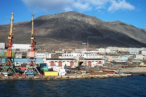
Provideniya
Urban-type settlement in Chukotka Autonomous Okrug, Russia
Distance: Approx. 4425 meters
Latitude and longitude: 64.41666667,-173.25
Provideniya (Russian: Провиде́ния, IPA: [prəvʲɪˈdʲenʲɪjə]; Chukchi: Гуврэл Guvrel) is an urban locality (an urban-type settlement) and the administrative center of Providensky District of Chukotka Autonomous Okrug, Russia, located on Komsomolskaya Bay (a part of Providence Bay) in the northeastern part of the autonomous okrug, across the Bering Strait from Alaska, and very close to the International Date Line. The population has declined in recent decades: 1,970 (2010 Census); 2,723 (2002 Census); 5,432 (1989 Soviet census).

Provideniya Bay Airport
Airport in Chukotka, Russia
Distance: Approx. 2783 meters
Latitude and longitude: 64.37833333,-173.24333333
Provideniya Bay Airport (Russian: Аэропорт «Бухта Провидения») (IATA: PVS, ICAO: UHMD) (also Urelik and Ureliki) is a small airport in Chukotka, Russia located 3 km southwest of Provideniya at the northern end of the Istikhed lake on the eastern side of Provideniya Bay. It services primarily small transport aircraft. A concrete apron contains four parking spaces.

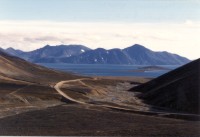
Providence Bay
Fjord in Siberia
Distance: Approx. 6077 meters
Latitude and longitude: 64.41666667,-173.4
Providence Bay (Russian: Бу́хта Провиде́ния, Bukhta Provideniya) is a fjord in the southern coast of the Chukchi Peninsula of northeastern Siberia. It was a popular rendezvous, wintering spot, and provisioning spot for whalers and traders in the nineteenth and early twentieth centuries. Emma Harbor (now Komsomolskaya Bay) is a large sheltered bay in the eastern shore of Providence Bay.
Providensky District
District in Chukotka Autonomous Okrug, Russia
Distance: Approx. 7804 meters
Latitude and longitude: 64.45,-173.25
Providensky District (Russian: Провиде́нский райо́н; Chukchi: Урэлӄуйым район, Urèlḳujym rajon; Yupik: Уӷрилӄуйым район) is an administrative and municipal district (raion), one of the six in Chukotka Autonomous Okrug, Russia. It is located in the northeast of the autonomous okrug, in the southern half of the Chukchi Peninsula with a northwest extension reaching almost to the Kolyuchinskaya Bay on the Arctic. It borders with Chukotsky District in the north, the Bering Sea in the east and south, and with Iultinsky District in the west.
Weather in this IP's area
snow
-10 Celsius
-17 Celsius
-10 Celsius
-10 Celsius
1012 hPa
95 %
1012 hPa
1012 hPa
116 meters
7.15 m/s
6.71 m/s
44 degree
100 %