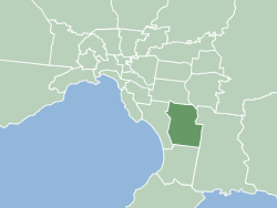
Country:
 Australia
Region:
City:
Latitude and Longitude:
Time Zone:
Postal Code:
IP information under different IP Channel
ip-api
Country
Region
City
ASN
Time Zone
ISP
Blacklist
Proxy
Latitude
Longitude
Postal
Route
IPinfo
Country
Region
City
ASN
Time Zone
ISP
Blacklist
Proxy
Latitude
Longitude
Postal
Route
MaxMind
Country
Region
City
ASN
Time Zone
ISP
Blacklist
Proxy
Latitude
Longitude
Postal
Route
Luminati
Country
AURegion
vic
City
fountaingate
ASN
Time Zone
Australia/Melbourne
ISP
Micron21 Datacentre Pty Ltd
Latitude
Longitude
Postal
db-ip
Country
Region
City
ASN
Time Zone
ISP
Blacklist
Proxy
Latitude
Longitude
Postal
Route
ipdata
Country
Region
City
ASN
Time Zone
ISP
Blacklist
Proxy
Latitude
Longitude
Postal
Route
Popular places and events near this IP address
City of Greater Dandenong
Local government area in Victoria, Australia
Distance: Approx. 3037 meters
Latitude and longitude: -38.01666667,145.34388889
The City of Greater Dandenong is a local government area in Victoria, Australia in the southeastern suburbs of Melbourne. It has an area of just under 130 square kilometres (50 sq mi) and 166,094 residents in 2018. 29% of its land area forms part of the South East Green Wedge.
Berwick, Victoria
Suburb of Melbourne, Victoria, Australia
Distance: Approx. 3077 meters
Latitude and longitude: -38.031,145.344
Berwick () is a large suburb in Melbourne, Victoria, Australia, 41 kilometres (25 mi) south-east of Melbourne's central business district, located within the City of Casey local government area. Berwick recorded a population of 50,298 at the 2021 census. It was named by an early leaseholder, Robert Gardiner, after his birthplace, Berwick-on-Tweed in Northumberland.
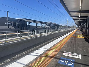
Narre Warren railway station
Railway station in Melbourne, Australia
Distance: Approx. 745 meters
Latitude and longitude: -38.0277,145.3039
Narre Warren railway station is a commuter railway station on the Pakenham line, which is part of the Melbourne railway network. It serves the south-eastern suburb of Narre Warren, in Melbourne, Victoria, Australia. Narre Warren station is an elevated hybrid structure premium station, featuring two side platforms.

Division of Holt
Australian federal electoral division
Distance: Approx. 3451 meters
Latitude and longitude: -38.044,145.281
The Division of Holt is an Australian Electoral Division in Victoria. It is located in the outer south-eastern suburbs of Melbourne, including Blind Bight, Botanic Ridge, Cannons Creek, Clyde, Cranbourne, Devon Meadows, Hampton Park, Junction Village, Lynbrook, and Warneet; and parts of Clyde North, Lyndhurst, Narre Warren South, Pearcedale and Tooradin.

Westfield Fountain Gate
Shopping mall in Victoria, Australia
Distance: Approx. 749 meters
Latitude and longitude: -38.01861111,145.30416667
Westfield Fountain Gate is a super-regional shopping centre located in Narre Warren in the south-eastern suburbs of Melbourne, Australia. It is the second largest shopping centre in Australia by both floor area and number of anchor tenants. However, it is the largest shopping centre in Australia with all 3 discount department stores, Big W, Target and Kmart.
Casey Radio
Radio station in Cranbourne East, Victoria
Distance: Approx. 2692 meters
Latitude and longitude: -38.003889,145.328611
Casey Radio 3SER is a non-commercial community radio station which caters to the greater south-eastern suburbs of Melbourne, Australia. As a community broadcaster, Casey Radio's role is to provide general local community programming including entertainment, news and information, and aims to "inform, entertain and involve" its listeners. The station caters to the communities' diverse needs with an eclectic mix, ranging from local council news to sport, country to comedy, retro to modern, rock to rockabilly, and a wide diversity of ethnic and multilingual programmes.

Federation University Australia, Berwick campus
Distance: Approx. 3200 meters
Latitude and longitude: -38.04,145.34
Federation University Australia, Berwick Campus is a campus of Federation University Australia located in Berwick, which is a suburb of Melbourne, Australia, in the state of Victoria. It is situated in the City of Casey, one of Australia's fastest-growing areas, with approximately 2000 students attending the campus. The campus covers an area of 55 ha (140 acres).

Wilson Botanic Park
Distance: Approx. 2621 meters
Latitude and longitude: -38.0251,145.3401
Wilson Botanic Park is a botanic garden located on Princes Highway in Berwick in Victoria, Australia.

Electoral district of Evelyn and Mornington
Australian electorate
Distance: Approx. 3288 meters
Latitude and longitude: -38,145.33333333
The Electoral district of Evelyn and Mornington was an electoral district of the Victorian Legislative Assembly. The district was based on the counties of Evelyn and Mornington, and defined in the Victoria Constitution Act 1855.

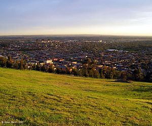
Narre Warren, Victoria
Suburb of Melbourne, Victoria, Australia
Distance: Approx. 1079 meters
Latitude and longitude: -38.018,145.3
Narre Warren ( NARR-ee WORR-ən) is a suburb in Melbourne, Victoria, Australia, 38 km southeast of Melbourne's Central Business District, located within the City of Casey local government area. Narre Warren recorded a population of 27,689 at the 2021 census. Narre Warren has a population density of over 2000 people per square kilometre.

Nossal High School
School in Australia
Distance: Approx. 2948 meters
Latitude and longitude: -38.03916667,145.33722222
Nossal High School, also referred to as Nossal or NHS, is a government-funded mixed-sex academically selective secondary day school, located in the Melbourne suburb of Berwick, Victoria, Australia. The school (named after Sir Gustav Nossal, a prominent Australian immunologist and 2000 Australian of the Year) was established in 2010 and caters for students in Year 9 to Year 12. The school's curriculum follows American educator Howard Gardener's concept of the Five Minds of the Future which includes, for example, the absence of school bells, as students are expected to know when and where to be.

Casey Airfield
Former airfield in Victoria, Australia
Distance: Approx. 2890 meters
Latitude and longitude: -38.03972222,145.33583333
Casey Airfield, later known as Berwick Airfield (ICAO: YBER), was a small airfield for light aircraft located in Berwick, Victoria, Australia. It was built by Rupert Ryan on land he had interited in 1935 and with his sister Ethel ("Maie") had turned it into a successful stud farm "Edrington". Maie had married Richard Casey (later Baron Casey, the 16th Governor-General of Australia) in 1921.
Weather in this IP's area
few clouds
17 Celsius
16 Celsius
16 Celsius
18 Celsius
1015 hPa
60 %
1015 hPa
1012 hPa
10000 meters
5.81 m/s
12.52 m/s
274 degree
24 %
06:30:16
18:03:04