Country:
Region:
City:
Latitude and Longitude:
Time Zone:
Postal Code:
IP information under different IP Channel
ip-api
Country
Region
City
ASN
Time Zone
ISP
Blacklist
Proxy
Latitude
Longitude
Postal
Route
Luminati
Country
ASN
Time Zone
Asia/Bangkok
ISP
KIRZ Service Provider
Latitude
Longitude
Postal
IPinfo
Country
Region
City
ASN
Time Zone
ISP
Blacklist
Proxy
Latitude
Longitude
Postal
Route
db-ip
Country
Region
City
ASN
Time Zone
ISP
Blacklist
Proxy
Latitude
Longitude
Postal
Route
ipdata
Country
Region
City
ASN
Time Zone
ISP
Blacklist
Proxy
Latitude
Longitude
Postal
Route
Popular places and events near this IP address
Thonburi
Former Thai capital city
Distance: Approx. 893 meters
Latitude and longitude: 13.725,100.48583333
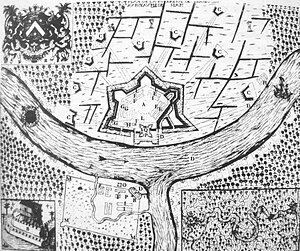
Thonburi (Thai: ธนบุรี) is an area of modern Bangkok. During the era of the Kingdom of Ayutthaya, its location on the right (west) bank at the mouth of the Chao Phraya River had made it an important garrison town, which is reflected in its name: thon (ธน) a loanword from Pali dhána 'wealth', and buri (บุรี), from púra, 'fortress'. The full formal name was Thon Buri Si Mahasamut (กรุงธนบุรีศรีมหาสมุทร 'City of Treasures Gracing the Ocean').
Thon Buri district
District in Bangkok, Thailand
Distance: Approx. 893 meters
Latitude and longitude: 13.725,100.48583333
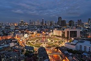
Thon Buri (Thai: ธนบุรี, pronounced [tʰōn būrīː]) is one of the 50 districts (khet) of Bangkok, Thailand. On the west bank of Chao Phraya River, it was once part of Thon Buri province. Neighboring districts are (from north clockwise) Bangkok Yai, Phra Nakhon (across Chao Phraya River), Khlong San, Bang Kho Laem (across Chao Phraya), Rat Burana, Chom Thong, and Phasi Charoen.
Wongwian Yai
Distance: Approx. 790 meters
Latitude and longitude: 13.7264,100.489175
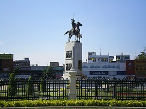
Wongwian Yai, also spelled "Wong Wian Yai" or "Wongwien Yai" (Thai: วงเวียนใหญ่, pronounced [wōŋ.wīa̯n jàj]; lit. 'big roundabout'), is a large roundabout (traffic circle) in Thonburi, on the west bank of the Chao Phraya River in Bangkok, Thailand, where the statue of King Taksin is situated. It overlaps between the four sub-districts of two districts, Bang Yi Ruea and Hiran Ruchi of Thon Buri with Somdet Chao Phraya and Khlong San of Khlong San in the centre of Bangkok, at the intersection of Prajadhipok/ Intharaphithak/ Lat Ya/ Somdet Phra Chao Taksin Roads. Nearby is Wongwian Yai Station, a historical commuter railway terminal to Maha Chai (local name of Samut Sakon provincial city) and Mae Khlong (Samut Songkhram), a southwestern suburb of Bangkok.
Secondary Demonstration School of Bansomdejchaopraya Rajabhat University
Distance: Approx. 267 meters
Latitude and longitude: 13.731903,100.488692
The Secondary Demonstration School of Bansomdejchaopraya Rajabhat University (โรงเรียนมัธยมสาธิตมหาวิยาลัยราชภัฏบ้านสมเด็จเจ้าพระยา, Abbreviated B.S. or บ.ส.) is a school in Bangkok, Thailand. It is affiliated with Bansomdejchaopraya Rajabhat University in Bangkok. The school was founded in 1914 by the East Teacher Training School (Chaopraya Pasakorn) on the recommendation of King Rama V .
Ton Son Mosque
Mosque in Bangkok, Thailand
Distance: Approx. 818 meters
Latitude and longitude: 13.74003,100.48869
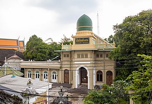
Ton Son Mosque (Thai: มัสยิดต้นสน) is a historic mosque affiliated with the Sunni religion of Islam. Located on the left bank of Khlong Bangkok Yai canal, Wat Arun Subdistrict, Bangkok Yai District, Bangkok's Thonburi side, opposite Wat Moli Lokayaram temple, across the canal is Bang Luang Mosque. The ancient mosque was founded in the Ayutthaya era during the reign of King Narai in 1688 by Chao Phraya Ratchawangsanseni (Mahmud).
Bang Yi Ruea
Khwaeng in Thailand
Distance: Approx. 639 meters
Latitude and longitude: 13.72728056,100.48705278
Bang Yi Ruea (Thai: บางยี่เรือ, pronounced [bāːŋ jîː rɯ̄a̯]) is a khwaeng (sub-district) in Thon Buri district, Thonburi side of Bangkok. It has a total area of 1.523 km2 (round about 0.588 mi2).

Bang Luang Mosque
Mosque in Bangkok, Thailand
Distance: Approx. 639 meters
Latitude and longitude: 13.73803,100.48935
Bang Luang Mosque (Thai: มัสยิดบางหลวง) is a historic mosque in Bangkok located in Soi Arun Amarin 7, New Arun Amarin Road, Wat Kanlaya Subdistrict, Thon Buri District, Thonburi side within Kudi Khao Community by the Khlong Bangkok Yai (formerly Khlong Bang Luang) near mouth of Chao Phraya River, it is also known as Kudi Khao (กุฎีขาว; lit: white cloister) and Kudi To Yi (กุฎีโต๊ะหยี; To Yi's cloister). This mosque was built in the early Rattanakosin period (approx. 1784) during the reign of King Phutthayotfa Chulalok (Rama I) by a Muslim merchant named "To Yi" (โต๊ะหยี).

Kudi Charoenphat
Distance: Approx. 430 meters
Latitude and longitude: 13.736853,100.486734
Kudi Charoenphat (Thai: กุฎีเจริญพาศน์) is a Mosque of Muslim Shia sect or Chao Sen (เจ้าเซ็น) in Thai perception, it was built during the reign of King Phutthayotfa Chulalok (Rama I) by Phraya Chula Ratchamontri II (Akayi) since early Rattanakosin era. The second mosque after Kudi Luang (กุฎีหลวง) is located by Bang Luang Canal, also known as Bangkok Yai Canal side close to Charoenphat Bridge (สะพานเจริญพาศน์). Formerly called Kudi Lang (กุฎีล่าง, "Lower Mosque") because it was located on the south of Kudi Bon (กุฎีบน, "Upper Mosque") which was situated on Chao Phraya River bank close to the Phra Racha Wang Derm (Thonburi Palace), the monastery's name has been changed to the present one since the reign of King Vajiravudh (Rama VI) when Charoenphat Bridge was constructed.

Wat Hong Rattanaram
Buddhist temple in Bangkok, Thailand
Distance: Approx. 737 meters
Latitude and longitude: 13.73944444,100.48805556
Wat Hong Rattanaram Ratchaworawihan, or just called Wat Hong Rattanaram (Thai: วัดหงส์รัตนารามราชวรวิหาร, วัดหงส์รัตนาราม) is an ancient Thai Buddhist temple located in Bangkok rim the Khlong Bangkok Yai canal. It is classified as the second rank of royal temple and can be considered a temple of Prince Pinklao. This temple built since late Ayutthaya period by wealthy Chinese named Hong, who was donated funds to build a temple on the banks of the Khlong Bangkok Yai.
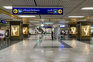
Itsaraphap MRT station
Subway station in Bangkok, Thailand
Distance: Approx. 617 meters
Latitude and longitude: 13.73841667,100.48530556
Itsaraphap station (Thai: สถานีอิสรภาพ, pronounced [sā.tʰǎː.nīː ʔìt.sā.rā.pʰâːp]) is a Bangkok MRT rapid transit station on the Blue Line. It is recognized as one of the four most beautiful MRT stations, along with Sanam Chai, Sam Yot, and Wat Mangkon stations. Itsaraphap station is the first and only underground station in the Thonburi side and is the last underground before elevating above ground to the Tha Phra station.

Hiran Ruchi
Khwaeng in Thailand
Distance: Approx. 636 meters
Latitude and longitude: 13.7289,100.4906
Hiran Ruchi (Thai: หิรัญรูจี, pronounced [hìʔ.rān rūː.t͡ɕīː]) is a khwaeng (sub-district) of seven sub-districts in Thon Buri district, Bangkok.
Pho Sam Ton, Bangkok
Road intersection in Bangkok, Thailand
Distance: Approx. 875 meters
Latitude and longitude: 13.74043889,100.48389444
Pho Sam Ton (Thai: โพธิ์สามต้น, pronounced [pʰōː sǎːm tôn]) is a three-way junction between the Itsaraphap and Wang Doem Roads in the area of Wat Tha Phra and Wat Arun subdistricts in the Bangkok Yai district. The name means "three Bodhi trees", commemorating the victory of King Taksin and King Rama I over the Burmese army in the Battle of Pho Sam Ton in November 1767. Pho Sam Ton was the site for the Burmese camp controlled by commanders Suki and Mongya.
Weather in this IP's area
overcast clouds
28 Celsius
33 Celsius
28 Celsius
29 Celsius
1010 hPa
88 %
1010 hPa
1010 hPa
10000 meters
1.64 m/s
2.32 m/s
1 degree
86 %
06:15:22
17:48:28
