Country:
Region:
City:
Latitude and Longitude:
Time Zone:
Postal Code:
IP information under different IP Channel
ip-api
Country
Region
City
ASN
Time Zone
ISP
Blacklist
Proxy
Latitude
Longitude
Postal
Route
Luminati
Country
Region
27
City
toyonaka
ASN
Time Zone
Asia/Tokyo
ISP
CYBER LINKS Co.,Ltd.
Latitude
Longitude
Postal
IPinfo
Country
Region
City
ASN
Time Zone
ISP
Blacklist
Proxy
Latitude
Longitude
Postal
Route
db-ip
Country
Region
City
ASN
Time Zone
ISP
Blacklist
Proxy
Latitude
Longitude
Postal
Route
ipdata
Country
Region
City
ASN
Time Zone
ISP
Blacklist
Proxy
Latitude
Longitude
Postal
Route
Popular places and events near this IP address

Toyonaka
Core city in Kansai, Japan
Distance: Approx. 1122 meters
Latitude and longitude: 34.78333333,135.46666667
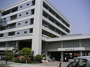
Toyonaka (豊中市, Toyonaka-shi) is a city in Osaka Prefecture, Japan. As of 1 May 2023, the city had an estimated population of 399,263 in 179651 households and a population density of 5700 persons per km2. The total area of the city is 36.39 square kilometres (14.05 sq mi).
Ishibashi handai-mae Station
Railway station in Ikeda, Osaka Prefecture, Japan
Distance: Approx. 2340 meters
Latitude and longitude: 34.808152,135.445456
Ishibashi handai-mae Station (石橋阪大前駅, Ishibashi handai-mae eki, station number: HK-48) is a train station located in Ikeda, Osaka, but is on the border with Toyonaka to the south and Minoh to the east. It serves as a transfer point for the Hankyu Minoo Line on one side and on the other side is an express station on the Hankyu Takarazuka Line.The station has five platforms connected by tunnels, two for Osaka-Takarazuka service, and three for Minoo service.
Hotarugaike Station
Railway and monorail station in Toyonaka, Osaka Prefecture, Japan
Distance: Approx. 1284 meters
Latitude and longitude: 34.79458889,135.44929167
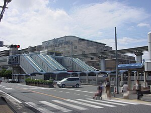
Hotarugaike Station (蛍池駅, Hotarugaike-eki) is a junction passenger railway station located in the city of Toyonaka, Osaka Prefecture, Japan. It is operated by the private transportation company Hankyu Railway and by the Osaka Monorail.

Hattori Ryokuchi Park
Distance: Approx. 2705 meters
Latitude and longitude: 34.77653611,135.48496389
Hattori Ryokuchi Park (服部緑地公園, Hattori Ryokuchi Kōen) is a large, hilly park in northern Osaka. It is most famous for its Open-Air Museum of Old Japanese Farmhouses, which contains examples of rural architecture from various parts of Japan. It also contains tennis courts, bamboo gardens, ponds, playgrounds, flower gardens, a concert hall, a "flower road", a horseback riding track, and a "water world".

Momoyamadai Station
Metro station in Suita, Osaka Prefecture, Japan
Distance: Approx. 3126 meters
Latitude and longitude: 34.792625,135.49738889
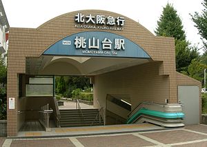
Momoyamadai (桃山台駅, Momoyamadai-eki) is a train station on the Kita-Osaka Kyuko Railway (which links directly into the Osaka Municipal Subway Midosuji Line) located in Suita, Osaka, Japan.

Shibahara-handai-mae Station
Monorail station in Toyonaka, Osaka Prefecture, Japan
Distance: Approx. 927 meters
Latitude and longitude: 34.80039722,135.45855
Shibahara-handai-mae Station (柴原阪大前駅, Shibahara-Handai-mae Eki) is a Japanese monorail station of Osaka Monorail in Toyonaka, Osaka Prefecture, Japan. "Handai" is a nickname in Japanese for Osaka University, and this station is close to the university's Toyonaka Campus. On October 1, 2019, this station was renamed from Shibahara Station (柴原駅).

Shōji Station (Toyonaka)
Monorail station in Toyonaka, Osaka Prefecture, Japan
Distance: Approx. 1682 meters
Latitude and longitude: 34.80427222,135.47544722
Shōji Station (少路駅, Shōji-eki) is a monorail station on the Osaka Monorail Main Line located in Toyonaka, Osaka Prefecture, Japan.

Sone Station (Osaka)
Railway station in Toyonaka, Osaka Prefecture, Japan
Distance: Approx. 2396 meters
Latitude and longitude: 34.771775,135.46754167
Sone Station (曽根駅, Sone-eki, station number: HK-44) is a passenger railway station located in the city of Toyonaka, Osaka Prefecture, Japan. It is operated by the private transportation company Hankyu Railway.

Okamachi Station
Railway station in Toyonaka, Osaka Prefecture, Japan
Distance: Approx. 1561 meters
Latitude and longitude: 34.779061,135.465047
Okamachi Station (岡町駅, Okamachi-eki, station number: HK-45) is a passenger railway station located in the city of Toyonaka, Osaka Prefecture, Japan. It is operated by the private transportation company Hankyu Railway.
Toyonaka Station
Railway station in Toyonaka, Osaka Prefecture, Japan
Distance: Approx. 629 meters
Latitude and longitude: 34.78756389,135.46134167
Toyonaka Station (豊中駅, Toyonaka-eki, station number: HK-46) is a passenger railway station located in the city of Toyonaka, Osaka Prefecture, Japan. It is operated by the private transportation company Hankyu Railway.

Sakurai Station (Osaka)
Railway station in Minoh, Osaka Prefecture, Japan
Distance: Approx. 2657 meters
Latitude and longitude: 34.81678333,135.46070278
Sakurai Station (桜井駅, Sakurai-eki, station number: HK-57) is a passenger railway station located in the city of Minoh, Osaka Prefecture, Japan. It is operated by the private transportation company Hankyu Railway.

Itami Airport
Airport in Hyogo and Osaka prefecture, Japan
Distance: Approx. 2395 meters
Latitude and longitude: 34.78444444,135.43916667
Osaka International Airport (大阪国際空港, Ōsaka Kokusai Kūkō) (IATA: ITM, ICAO: RJOO), often referred to as Itami Airport (伊丹空港, Itami Kūkō), is the primary regional airport for the Kansai region of Japan, including the major cities of Osaka, Kyoto, and Kobe. It is the airport closest to Kyoto, 36 km (22 mi) southwest of Kyoto Station. Itami Airport has a small footprint, covering only 311 hectares (768 acres) of land.
Weather in this IP's area
broken clouds
16 Celsius
16 Celsius
16 Celsius
18 Celsius
1019 hPa
82 %
1019 hPa
1016 hPa
10000 meters
1.54 m/s
340 degree
75 %
06:33:13
16:52:51


