24.97.200.100 - IP Lookup: Free IP Address Lookup, Postal Code Lookup, IP Location Lookup, IP ASN, Public IP
Country:
Region:
City:
Location:
Time Zone:
Postal Code:
IP information under different IP Channel
ip-api
Country
Region
City
ASN
Time Zone
ISP
Blacklist
Proxy
Latitude
Longitude
Postal
Route
Luminati
Country
Region
ny
City
mountvernon
ASN
Time Zone
America/New_York
ISP
TWC-12271-NYC
Latitude
Longitude
Postal
IPinfo
Country
Region
City
ASN
Time Zone
ISP
Blacklist
Proxy
Latitude
Longitude
Postal
Route
IP2Location
24.97.200.100Country
Region
new york
City
mount vernon
Time Zone
America/New_York
ISP
Language
User-Agent
Latitude
Longitude
Postal
db-ip
Country
Region
City
ASN
Time Zone
ISP
Blacklist
Proxy
Latitude
Longitude
Postal
Route
ipdata
Country
Region
City
ASN
Time Zone
ISP
Blacklist
Proxy
Latitude
Longitude
Postal
Route
Popular places and events near this IP address
Mount Vernon, New York
City in New York, United States
Distance: Approx. 578 meters
Latitude and longitude: 40.91416667,-73.83055556
Mount Vernon is a city in Westchester County, New York, United States. It is an inner suburb of New York City, immediately to the north of the borough of the Bronx. As of the 2020 census, Mount Vernon had a population of 73,893, making it the 24th-largest municipality in the state and largest African-American majority city in the state.

Bronx River Road
Distance: Approx. 1133 meters
Latitude and longitude: 40.9146,-73.8503
Bronx River Road is a major street and neighborhood in Yonkers, New York. It runs alongside the Bronx River, Bronx River Parkway, and Metro-North railroad tracks in south-eastern Yonkers. On the other side of the Bronx River is the City of Mount Vernon, New York as well as the Bronx.
Mount Vernon West station
Metro-North Railroad station in New York
Distance: Approx. 1103 meters
Latitude and longitude: 40.913,-73.8502
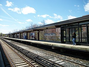
Mount Vernon West station is a commuter rail stop on the Metro-North Railroad's Harlem Line, located in Mount Vernon, New York. Train 357 from Grand Central Terminal terminates here in the PM Rush.

Wakefield–241st Street station
New York City Subway station in the Bronx
Distance: Approx. 1523 meters
Latitude and longitude: 40.903,-73.85
The Wakefield–241st Street station (signed as 241st Street) is a terminal station on the IRT White Plains Road Line of the New York City Subway, located at the intersection of 241st Street and White Plains Road in the Wakefield neighborhood of the Bronx. It is served by the 2 train at all times. This station is geographically the northernmost station in the entire New York City Subway system.
Mount Vernon East station
Metro-North Railroad station in New York
Distance: Approx. 462 meters
Latitude and longitude: 40.911942,-73.831678
Mount Vernon East station is a commuter rail station on the Metro-North Railroad New Haven Line, located in Mount Vernon, New York. The station is the first station north of the junction where the New Haven Line splits from the Harlem Line and is the northernmost station on the line before it changes from third rail power to overhead catenary power, which takes place between the Mount Vernon East and Pelham stations.

First United Methodist Church (Mount Vernon, New York)
Historic church in New York, United States
Distance: Approx. 923 meters
Latitude and longitude: 40.91833333,-73.82916667
First United Methodist Church, also known as Chester Hill ME Church, is a historic United Methodist church at 227 E. Lincoln Avenue in Mount Vernon, Westchester County, New York, United States. It was built in 1900-1901 and is a Romanesque Revival style building. It is constructed of granite with limestone details and a red slate roof.
Trinity Episcopal Church Complex (Mount Vernon, New York)
Historic church in New York, United States
Distance: Approx. 1096 meters
Latitude and longitude: 40.90305556,-73.83388889
Trinity Episcopal Church Complex is a historic Episcopal church complex at 335 Fourth Avenue in Mount Vernon, Westchester County, New York. It is two blocks south of its mother church, Saint Paul's Church. The complex consists of the church (1859), old parish hall (1892), new parish hall (1909; 1954), and rectory (1893).

United States Post Office (Mount Vernon, New York)
United States historic place
Distance: Approx. 337 meters
Latitude and longitude: 40.91111111,-73.83361111
US Post Office-Mount Vernon is a historic post office building located at Mount Vernon in Westchester County, New York, United States. It was built in 1915 and is one of a number of post offices designed by the Office of the Supervising Architect under direction of Oscar Wenderoth. It is a two to three story, symmetrical building faced with limestone in the Classical Revival style.
John Stevens House
Historic house in New York, United States
Distance: Approx. 948 meters
Latitude and longitude: 40.90416667,-73.83555556
John Stevens House is a historic home located at Mount Vernon, Westchester County, New York. It was built between 1849 and 1851 and is a five-by-three-bay, 2+1⁄2-story, substantial frame farmhouse. It features a 1-story porch across the front elevation that incorporates six Doric order columns and a dentiled cornice.
Mount Vernon City School District (New York)
School district in the U.S. state of New York
Distance: Approx. 577 meters
Latitude and longitude: 40.91417,-73.83056
The Mount Vernon City School District (MVCSD) is a public school district located in Mount Vernon, New York. Consisting over 11 Pre-K through 8th grade neighborhood schools and two high schools, the district serves over 8,000 students from the City of Mount Vernon. In August 2015 the Mount Vernon Board of Trustees appointed Dr.

September 2013 New Haven Line power outage
Unplanned electrical power outage
Distance: Approx. 674 meters
Latitude and longitude: 40.9112,-73.8293
The September 2013 New Haven Line power outage was an unplanned electrical power outage that impacted service on Metro-North Railroad's New Haven Line for twelve days in 2013. On September 25, 2013, a 138-kV main feeder cable from Con Edison that provided electricity to an AC catenary-powered 8-mile (13 km) segment of the New Haven Line failed, causing electric train service over the line to halt between Mount Vernon, New York and Harrison, New York.
Mount Vernon Hospital, New York
New York (state) hospital and trauma center
Distance: Approx. 249 meters
Latitude and longitude: 40.91357657,-73.8397598
Montefiore Mount Vernon Hospital is an 1890s-founded hospital that had been "designated a total-care trauma facility since 1984." In 1986 they expanded and added "a new 20-bed psychiatric unit and a rehabilitation unit." The hospital also formed an AIDS program. The Mount Vernon hospital changed its name to Montefiore Mount Vernon Hospital when it was taken over by Montefiore Health Systems.
Weather in this IP's area
mist
12 Celsius
11 Celsius
10 Celsius
13 Celsius
1003 hPa
88 %
1003 hPa
999 hPa
9656 meters
4.63 m/s
170 degree
100 %


