24.72.151.29 - IP Lookup: Free IP Address Lookup, Postal Code Lookup, IP Location Lookup, IP ASN, Public IP
Country:
 USA
USARegion:
City:
Location:
Time Zone:
Postal Code:
ISP:
ASN:
language:
User-Agent:
Proxy IP:
Blacklist:
IP information under different IP Channel
ip-api
Country
Region
City
ASN
Time Zone
ISP
Blacklist
Proxy
Latitude
Longitude
Postal
Route
db-ip
Country
Region
City
ASN
Time Zone
ISP
Blacklist
Proxy
Latitude
Longitude
Postal
Route
IPinfo
Country
Region
City
ASN
Time Zone
ISP
Blacklist
Proxy
Latitude
Longitude
Postal
Route
IP2Location
24.72.151.29Country
usRegion
california
City
sherman oaks
Time Zone
America/Los_Angeles
ISP
Language
User-Agent
Latitude
Longitude
Postal
ipdata
Country
Region
City
ASN
Time Zone
ISP
Blacklist
Proxy
Latitude
Longitude
Postal
Route
Popular places and events near this IP address

Coast to Coast AM
American radio talk show
Distance: Approx. 607 meters
Latitude and longitude: 34.15333333,-118.46555556
Coast to Coast AM is an American late-night radio talk show that deals with a variety of topics. Most frequently the topics relate to either the paranormal or conspiracy theories. It was hosted by creator Art Bell from its inception in 1988 until 2003, and is currently hosted by George Noory.

Sherman Oaks, Los Angeles
Neighborhood of Los Angeles in California, United States
Distance: Approx. 1675 meters
Latitude and longitude: 34.15111111,-118.44833333
Sherman Oaks (founded in 1927) is a neighborhood of the city of Los Angeles, California within the San Fernando Valley region. The neighborhood includes a portion of the Santa Monica Mountains, which gives Sherman Oaks a lower population density than some other areas in Los Angeles.

Sepulveda Dam
Dam in San Fernando Valley, California
Distance: Approx. 2235 meters
Latitude and longitude: 34.1671,-118.4732
The Sepulveda Dam is a dry dam constructed by the U.S. Army Corps of Engineers to withhold winter flood waters along the Los Angeles River. Completed in 1941, at a cost of $6,650,561 (equivalent to $137,766,000 in 2023), it is located south of center in the San Fernando Valley, approximately eight miles (13 km) east of the river's source in the western end of the Valley, in Los Angeles, California. Sepulveda Dam, along with Hansen Dam located in the north San Fernando Valley, was constructed in response to the historic 1938 floods which killed 144 people.

Sherman Oaks Galleria
Shopping mall in California, U.S.
Distance: Approx. 700 meters
Latitude and longitude: 34.15416667,-118.46666667
Sherman Oaks Galleria is an open-air shopping mall and business center located in the Sherman Oaks neighborhood of Los Angeles, California, United States, at the corner of Ventura and Sepulveda Boulevards in the San Fernando Valley. The teenage mall culture which formed around it and nearby malls formed the basis of the 1982 satirical song "Valley Girl" by Frank Zappa and daughter Moon Zappa, which mentions the Galleria by name, though it misattributes its location as Encino, which it abuts. The mall has been a shooting location for many films, most notably the seminal 1982 film Fast Times at Ridgemont High as well as the 1983 film Valley Girl, both of which focused on the early 1980s San Fernando Valley youth culture.
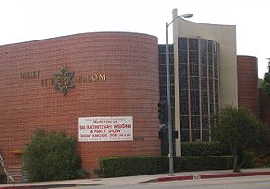
Valley Beth Shalom
Conservative synagogue in Los Angeles, California, United States
Distance: Approx. 1311 meters
Latitude and longitude: 34.15560833,-118.47685556
Valley Beth Shalom (informally called VBS) is a Conservative synagogue at 15739 Ventura Boulevard in Encino, Los Angeles, California, in the United States. With approximately 1,500 member families, it is one of the largest synagogues in Los Angeles and one of the largest Conservative synagogues in the United States.

St. Cyril of Jerusalem Church and School
Catholic Church in California, United States
Distance: Approx. 933 meters
Latitude and longitude: 34.15442,-118.47247
St. Cyril of Jerusalem Church and School is a Catholic church and elementary school located in Encino, Los Angeles. Founded in 1949, St.

Proto-Cathedral of St. Mary
Ruthenian Greek Catholic church in the US
Distance: Approx. 2180 meters
Latitude and longitude: 34.16748056,-118.466575
The Proto-Cathedral of St. Mary or Proto-Cathedral of St. Mary Byzantine Catholic Church is a parish church and proto-cathedral of the Byzantine Catholic Eparchy of Phoenix, serving the Ruthenian Eastern Catholic population of Los Angeles, California, United States.

Stephen Wise Temple
Synagogue in Los Angeles, California, USA
Distance: Approx. 2209 meters
Latitude and longitude: 34.128247,-118.469413
Stephen Wise Temple is a large Reform Jewish congregation in the Bel Air neighborhood of Los Angeles, California, in the United States. Founded in 1964 by the late Rabbi Isaiah Zeldin, with 35 families, the congregation grew rapidly. At various times in its history it has been stated to be the largest, or one of the largest, Jewish congregations in the world, at one time having a membership of approximately 3,000 families, six rabbis, two cantors and two cantorial interns, and four schools on three campuses.

Encino Hospital Medical Center
Hospital in California, United States
Distance: Approx. 2152 meters
Latitude and longitude: 34.15711,-118.48664
The Encino Hospital Medical Center is a hospital in Encino, California. The hospital's ownership changed in June 2008 when Tenet Healthcare sold it to the current owner, Prime Healthcare Services. Previously, the hospital was one of the campuses of the Encino-Tarzana Regional Medical Center.
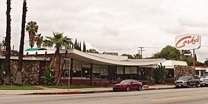
Corky's
Restaurant in California, United States
Distance: Approx. 2259 meters
Latitude and longitude: 34.16244,-118.448989
Corky's was a restaurant in Los Angeles, California's Sherman Oaks neighborhood. It was designed by Armet & Davis and built in 1958. It has a sweeping roofline characteristic of Googie architecture.
Anajak Thai
Thai restaurant in Los Angeles, California, U.S.
Distance: Approx. 1244 meters
Latitude and longitude: 34.15152778,-118.45333333
Anajak Thai is a Thai restaurant in Sherman Oaks, California. The business earned Justin Pichetrungsi a James Beard Foundation Award in the Best Chef: California category.
Humphrey Yogurt
Restaurant in California, United States of America
Distance: Approx. 1849 meters
Latitude and longitude: 34.153,-118.447
Humphrey Yogurt is a frozen yogurt shop in Sherman Oaks, Los Angeles. The store was established by Maria and Raphael Baker in 1984. Current owner Paula Sheftel purchased the store in 1986 for $110,000.
Weather in this IP's area
clear sky
16 Celsius
15 Celsius
12 Celsius
17 Celsius
1016 hPa
69 %
1016 hPa
987 hPa
10000 meters