Country:
Region:
City:
Latitude and Longitude:
Time Zone:
Postal Code:
IP information under different IP Channel
ip-api
Country
Region
City
ASN
Time Zone
ISP
Blacklist
Proxy
Latitude
Longitude
Postal
Route
Luminati
Country
Region
mn
City
rushcity
ASN
Time Zone
America/Chicago
ISP
MIDCO-NET
Latitude
Longitude
Postal
IPinfo
Country
Region
City
ASN
Time Zone
ISP
Blacklist
Proxy
Latitude
Longitude
Postal
Route
db-ip
Country
Region
City
ASN
Time Zone
ISP
Blacklist
Proxy
Latitude
Longitude
Postal
Route
ipdata
Country
Region
City
ASN
Time Zone
ISP
Blacklist
Proxy
Latitude
Longitude
Postal
Route
Popular places and events near this IP address

Harris, Minnesota
City in Minnesota, United States
Distance: Approx. 9950 meters
Latitude and longitude: 45.59361111,-92.98027778
Harris is a city in Chisago County, Minnesota, United States. The population was 1,132 at the 2010 census. There is a restaurant, a post office, a bar and grill, and tattoo shop, among other businesses.
Nessel Township, Chisago County, Minnesota
Township in Minnesota, United States
Distance: Approx. 8397 meters
Latitude and longitude: 45.68638889,-93.07111111
Nessel Township is a township in Chisago County, Minnesota, United States. The population was 1,951 at the 2010 census.

Rush City, Minnesota
City in Minnesota, United States
Distance: Approx. 537 meters
Latitude and longitude: 45.68527778,-92.96861111
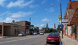
Rush City is a city in Chisago County, Minnesota, United States. The population was 3,228 at the 2020 census. It is fifty-eight miles north of Minneapolis–Saint Paul.
Rushseba Township, Chisago County, Minnesota
Township in Minnesota, United States
Distance: Approx. 2532 meters
Latitude and longitude: 45.68833333,-92.93194444
Rushseba Township is a township in Chisago County, Minnesota, United States. The population was 804 at the 2010 census.

Rock Creek, Minnesota
City in Minnesota, United States
Distance: Approx. 9693 meters
Latitude and longitude: 45.76055556,-92.90888889
Rock Creek is a city in Pine County, Minnesota, United States. The population was 1,628 at the 2010 census. Portions of the Mille Lacs Indian Reservation are located within Rock Creek.
Benson, Wisconsin
Unincorporated community in Wisconsin, United States
Distance: Approx. 9220 meters
Latitude and longitude: 45.71722222,-92.85583333
Benson is an unincorporated community in the town of Anderson, Burnett County, Wisconsin, United States. The community takes its name from Sven Johann Bengston, a local shopkeeper. A post office with the name of Randall was in operation here from 1885 to 1929.
Minnesota Correctional Facility – Rush City
Distance: Approx. 3185 meters
Latitude and longitude: 45.70876,-92.94806
The Minnesota Correctional Facility – Rush City is a prison for men operated by the Minnesota Department of Corrections in Rush City, Chisago County, Minnesota. Rush City is the state's newest prison, opened in January 2000. The $89 million project stands as the largest single structure in the county, employs about 350 workers, and at the ten-year mark in 2010 was reported to have met local expectations as a quiet and relatively well-run prison.
Rush City Regional Airport
Airport in Minnesota, U.S.
Distance: Approx. 2492 meters
Latitude and longitude: 45.70333333,-92.97388889
Rush City Regional Airport (ICAO: KROS, FAA LID: ROS) is a city-owned public-use airport located in Chisago County, Minnesota, one nautical mile northeast of the central business district of Rush City, a city in Chisago County, Minnesota, United States.
Neander Lake
Lake in the state of Minnesota, United States
Distance: Approx. 9039 meters
Latitude and longitude: 45.62666667,-93.04805556
Neander Lake is a lake in Chisago County, Minnesota, in the United States. Neander Lake was named for Nels P. Neander, a pioneer settler.
Rock Creek (Minnesota)
Stream in Chisago and Pine County, Minnesota, U.S.
Distance: Approx. 8124 meters
Latitude and longitude: 45.71305556,-92.86861111
Rock Creek is a stream in Chisago and Pine counties, in the U.S. state of Minnesota. Rock Creek was named for the rock outcroppings near its mouth.
Leech Lake (Chisago County, Minnesota)
Lake in the state of Minnesota, United States
Distance: Approx. 6729 meters
Latitude and longitude: 45.65833333,-93.04277778
Leech Lake is a lake in Chisago County, Minnesota, in the United States. Leech Lake was named for the great number of leeches in its waters.
Weather in this IP's area
scattered clouds
8 Celsius
7 Celsius
8 Celsius
9 Celsius
1019 hPa
87 %
1019 hPa
985 hPa
10000 meters
2.7 m/s
3.62 m/s
192 degree
32 %
07:12:15
16:41:05