Country:
 USA
USARegion:
City:
Latitude and Longitude:
Time Zone:
Postal Code:
IP information under different IP Channel
ip-api
Country
Region
City
ASN
Time Zone
ISP
Blacklist
Proxy
Latitude
Longitude
Postal
Route
IPinfo
Country
Region
City
ASN
Time Zone
ISP
Blacklist
Proxy
Latitude
Longitude
Postal
Route
MaxMind
Country
Region
City
ASN
Time Zone
ISP
Blacklist
Proxy
Latitude
Longitude
Postal
Route
Luminati
Country
USRegion
il
City
arenzville
ASN
Time Zone
America/Chicago
ISP
CASSCOMM
Latitude
Longitude
Postal
db-ip
Country
Region
City
ASN
Time Zone
ISP
Blacklist
Proxy
Latitude
Longitude
Postal
Route
ipdata
Country
Region
City
ASN
Time Zone
ISP
Blacklist
Proxy
Latitude
Longitude
Postal
Route
Popular places and events near this IP address
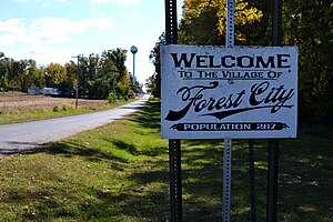
Forest City, Illinois
Village in Illinois, United States
Distance: Approx. 1151 meters
Latitude and longitude: 40.37222222,-89.8325
Forest City is a village in Mason County, Illinois, United States. The population was 222 at the 2020 census.

Manito, Illinois
Village in Illinois, United States
Distance: Approx. 7975 meters
Latitude and longitude: 40.42,-89.78055556
Manito is a village in Mason County, Illinois, United States. The population was 1,552 at the 2020 census, down from 1,642 in 2010.

Topeka, Illinois
Village in Illinois, United States
Distance: Approx. 8755 meters
Latitude and longitude: 40.33027778,-89.93055556
Topeka is an incorporated village in Mason County, Illinois, United States. The population was 60 at the 2020 census.

Sand Ridge State Forest
State forest in Illinois, United States
Distance: Approx. 6021 meters
Latitude and longitude: 40.41138889,-89.86611111
Sand Ridge State Forest is a conservation area located in the U.S. state of Illinois. Containing 7,200 acres (2,900 ha), it is the largest state forest in Illinois. It is located in northern Mason County.
Clear Lake Site
Archaeological site in Illinois, United States
Distance: Approx. 8253 meters
Latitude and longitude: 40.42277778,-89.78
Clear Lake Site is an archaeological site located in Sand Ridge State Park 6.5 miles (10.5 km) from Manito, Illinois. The site was occupied for the majority of the period from 500 B.C. to 1500 A.D.; cultures which have occupied the site include the Early Woodland, Havana Hopewell, and Mississippian. The site consists of a village area and two burial mounds.

Forest City Township, Mason County, Illinois
Township in Illinois, United States
Distance: Approx. 2903 meters
Latitude and longitude: 40.33972222,-89.81916667
Forest City Township is located in Mason County, Illinois. As of the 2010 census, its population was 522 and it contained 228 housing units.

Manito Township, Mason County, Illinois
Township in Illinois, United States
Distance: Approx. 6396 meters
Latitude and longitude: 40.39083333,-89.77083333
Manito Township is located in Mason County, Illinois, United States. As of the 2010 census, its population was 2,466 and it contained 1,088 housing units.

Quiver Township, Mason County, Illinois
Township in Illinois, United States
Distance: Approx. 8731 meters
Latitude and longitude: 40.37777778,-89.93722222
Quiver Township is located in Mason County, Illinois, United States. As of the 2010 census, its population was 900 and it contained 517 housing units. Quiver Township took its name from Quiver Creek.
Goofy Ridge, Illinois
Census-designated place in Illinois, United States
Distance: Approx. 9583 meters
Latitude and longitude: 40.395,-89.94083333
Goofy Ridge is an unincorporated community and census-designated place in Quiver Township, Mason County, Illinois, United States. As of the 2020 census, its population was 210, down from 350 in 2010. Goofy Ridge is given Topeka mailing addresses.
Bishop, Illinois
Unincorporated community in Illinois, United States
Distance: Approx. 3740 meters
Latitude and longitude: 40.34583333,-89.87472222
Bishop is an unincorporated community in Forest City Township, Mason County, Illinois, United States. Bishop is 3 miles (4.8 km) west-southwest of Forest City. The community was founded in 1875 as a station on the Peoria, Pekin and Jacksonville Railroad.
Weather in this IP's area
clear sky
16 Celsius
14 Celsius
15 Celsius
17 Celsius
1032 hPa
35 %
1032 hPa
1014 hPa
10000 meters
3.11 m/s
3.78 m/s
194 degree
07:14:50
18:13:15