Country:
 USA
USARegion:
City:
Latitude and Longitude:
Time Zone:
Postal Code:
IP information under different IP Channel
ip-api
Country
Region
City
ASN
Time Zone
ISP
Blacklist
Proxy
Latitude
Longitude
Postal
Route
IPinfo
Country
Region
City
ASN
Time Zone
ISP
Blacklist
Proxy
Latitude
Longitude
Postal
Route
MaxMind
Country
Region
City
ASN
Time Zone
ISP
Blacklist
Proxy
Latitude
Longitude
Postal
Route
Luminati
Country
USRegion
il
City
riverton
ASN
Time Zone
America/Chicago
ISP
CASSCOMM
Latitude
Longitude
Postal
db-ip
Country
Region
City
ASN
Time Zone
ISP
Blacklist
Proxy
Latitude
Longitude
Postal
Route
ipdata
Country
Region
City
ASN
Time Zone
ISP
Blacklist
Proxy
Latitude
Longitude
Postal
Route
Popular places and events near this IP address

Clear Lake, Illinois
Former village in Illinois, United States
Distance: Approx. 7350 meters
Latitude and longitude: 39.81416667,-89.56694444
Clear Lake is an unincorporated community and former incorporated village in Sangamon County, Illinois, United States. The population was 267 at the 2000 census. It is part of the Springfield, Illinois Metropolitan Statistical Area.
Dawson, Illinois
Village in Illinois, United States
Distance: Approx. 4251 meters
Latitude and longitude: 39.85444444,-89.46111111
Dawson is a village in Sangamon County, Illinois, United States. The population was 519 at the 2020 census. It is about 10 miles (16 km) east of Springfield and is part of the Springfield Metropolitan Statistical Area.
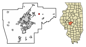
Riverton, Illinois
Village in Illinois, United States
Distance: Approx. 3113 meters
Latitude and longitude: 39.84833333,-89.54027778
Riverton is a village in Sangamon County, Illinois, United States. The population was 3,455 at the 2010 census, up from 3,062 in 2000. It is part of the Springfield, Illinois Metropolitan Statistical Area.

Spaulding, Illinois
Village in Illinois, United States
Distance: Approx. 2757 meters
Latitude and longitude: 39.86527778,-89.54166667
Spaulding is a village in Sangamon County, Illinois, United States. The population was 873 at the 2010 census. It is part of the Springfield, Illinois Metropolitan Statistical Area.
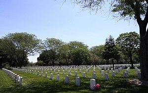
Camp Butler National Cemetery
Historic veterans cemetery in Sangamon County, Illinois
Distance: Approx. 5236 meters
Latitude and longitude: 39.8334963,-89.5568939
Camp Butler National Cemetery is a United States National Cemetery located a few miles northeast of Springfield and a few miles southwest of Riverton, a small town nearby to Springfield, in Sangamon County, Illinois. It was named for the Illinois State Treasurer at the time of its establishment, William Butler. Administered by the United States Department of Veterans Affairs, it occupies approximately 53 acres (21 ha), and is the site of 19,825 interments as of the end of 2005.

Clear Lake Township, Sangamon County, Illinois
Township in Illinois, United States
Distance: Approx. 4662 meters
Latitude and longitude: 39.83027778,-89.54305556
Clear Lake Township is located in Sangamon County, Illinois, United States. As of the 2010 census, its population was 8,527 and it contained 3,418 housing units.

Williams Township, Sangamon County, Illinois
Township in Illinois, United States
Distance: Approx. 7508 meters
Latitude and longitude: 39.925,-89.545
Williams Township is located in Sangamon County, Illinois. As of the 2010 census, its population was 3,446 and it contained 1,332 housing units.

Sugar Creek (Sangamon River tributary)
River
Distance: Approx. 6457 meters
Latitude and longitude: 39.8111609,-89.5425962
Sugar Creek, a tributary of the Sangamon River, is a large creek in central Illinois, United States. It rises in Talkington Township in southwestern Sangamon County, flows briefly through northeastern Macoupin County, and then runs northeastward through south-central Sangamon County before discharging into Lake Springfield. The creek drains Auburn and Virden, Illinois and has a total length of 52.8 miles (85.0 km).
Midwest Technical Institute
Distance: Approx. 7684 meters
Latitude and longitude: 39.840547,-89.59439
Midwest Technical Institute (MTI) is a private for-profit trade school in Springfield, Illinois. The college focuses on the mechanical trades, allied health, cosmetology, and commercial driving fields. Midwest Technical Institute has branch campuses in East Peoria, Illinois, Moline, Illinois, Springfield, Illinois, and Springfield, Missouri.
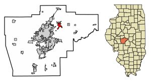
Barclay, Illinois
Unincorporated community in Illinois, United States
Distance: Approx. 1455 meters
Latitude and longitude: 39.87472222,-89.51777778
Barclay is an unincorporated community in Clear Lake and Williams townships, Sangamon County, Illinois, United States. Barclay is located on Illinois Route 54 and the Canadian National Railway, 1.3 miles (2.1 km) northeast of Spaulding.
Bissell, Illinois
Unincorporated community in Illinois, United States
Distance: Approx. 6457 meters
Latitude and longitude: 39.84611111,-89.58166667
Bissell is an unincorporated community in Clear Lake Township, Sangamon County, Illinois, United States. Bissell is located on Illinois Route 54 and the Canadian National Railway near the northeast border of Springfield.
Buffalo Hart, Illinois
Unincorporated community in Illinois, United States
Distance: Approx. 7730 meters
Latitude and longitude: 39.91388889,-89.4475
Buffalo Hart is an unincorporated community in northern Sangamon County in the U.S. state of Illinois. It is the population center of its own township, Buffalo Hart Township. Buffalo Hart was originally built in the 19th century, first as a frontier settlement based on a prairie grove, and then as a rural station stop on the Gilman, Clinton and Springfield Railroad twelve miles northeast of Springfield, Illinois, the state capital.
Weather in this IP's area
clear sky
30 Celsius
29 Celsius
29 Celsius
31 Celsius
1016 hPa
42 %
1016 hPa
997 hPa
10000 meters
1.54 m/s
140 degree
06:40:31
19:05:06