Country:
 USA
USARegion:
City:
Latitude and Longitude:
Time Zone:
Postal Code:
IP information under different IP Channel
ip-api
Country
Region
City
ASN
Time Zone
ISP
Blacklist
Proxy
Latitude
Longitude
Postal
Route
IPinfo
Country
Region
City
ASN
Time Zone
ISP
Blacklist
Proxy
Latitude
Longitude
Postal
Route
MaxMind
Country
Region
City
ASN
Time Zone
ISP
Blacklist
Proxy
Latitude
Longitude
Postal
Route
Luminati
Country
USRegion
ne
City
elkhorn
ASN
Time Zone
America/Chicago
ISP
GREAT-PLAINS-COMMUNICATIONS
Latitude
Longitude
Postal
db-ip
Country
Region
City
ASN
Time Zone
ISP
Blacklist
Proxy
Latitude
Longitude
Postal
Route
ipdata
Country
Region
City
ASN
Time Zone
ISP
Blacklist
Proxy
Latitude
Longitude
Postal
Route
Popular places and events near this IP address
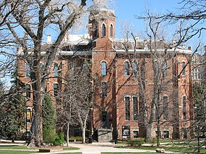
University of Colorado
Public university system in Colorado, US
Distance: Approx. 372 meters
Latitude and longitude: 39.745196,-104.98334
The University of Colorado (CU) is a system of public universities in Colorado. It consists of four institutions: the University of Colorado Boulder, the University of Colorado Colorado Springs, the University of Colorado Denver, and the University of Colorado Anschutz Medical Campus. It is governed by the elected, nine-member board of regents.

Wells Fargo Center (Denver)
Skyscraper located in Denver, Colorado
Distance: Approx. 503 meters
Latitude and longitude: 39.7446,-104.9848
Wells Fargo Center is a skyscraper located in Denver, Colorado, United States. The building is also known by its former name One Norwest Center. It is known colloquially as the Cash Register Building for the way its uppermost floors curve together resembling the shape of an antique cash register.

Avenue Theater
Building in CO, USA
Distance: Approx. 316 meters
Latitude and longitude: 39.74333333,-104.98166667
The Avenue Theater, located at 417 E. 17th Avenue in Downtown Denver, Colorado has been a producing comedies, musicals, and plays as well as improvisational comedy for 39 years.

Denver Financial Center
High-rise office building in Denver, Colorado
Distance: Approx. 503 meters
Latitude and longitude: 39.7446,-104.9848
Denver Financial Center I is a high-rise office building located at 1775 Sherman Street in Denver, Colorado. Built in 1981 as the Mellon Financial Center, the tower has 32 floors. At 374 feet (114 m), it is currently the 23rd tallest building in Denver.

North Capitol Hill, Denver
Neighborhood in Denver, Colorado, US
Distance: Approx. 364 meters
Latitude and longitude: 39.74327,-104.98234
North Capitol Hill, often referred to as Uptown, is a center city neighborhood near the Colorado State Capitol. The neighborhood has a diverse population, and is similar to surrounding neighborhoods of Five Points and Capitol Hill, in that it cannot be defined by a single demographic. Currently, downtown is undergoing significant redevelopment and gentrification, with many young residents and transplants populating the apartments and homes that frequent the area.
Independence Institute
Colorado based libertarian think tank
Distance: Approx. 390 meters
Latitude and longitude: 39.7419,-104.9779
The Independence Institute (II) is a libertarian think tank based in Denver, Colorado.

Sherman Street Event Center
United States historic place
Distance: Approx. 423 meters
Latitude and longitude: 39.74472222,-104.98388889
The Mosque of the El Jebel Shrine, which has also been known as the Rocky Mountain Consistory, and as the Scottish Rite Temple is a historic building in the North Capitol Hill neighborhood of downtown Denver. It was for a period known as Sherman Street Event Center The Moorish-inspired building was constructed in 1907, as a meeting hall for the El Jabel chapter of the Ancient Arabic Order of the Nobles of the Mystic Shrine (the Shriners). It has never been a true mosque in the Islamic sense.

Fillmore Auditorium (Denver)
Concert venue in Denver, Colorado
Distance: Approx. 551 meters
Latitude and longitude: 39.74055556,-104.97715556
The Fillmore Auditorium (often known as The Fillmore Denver) is a concert venue located in the Capitol Hill neighborhood in Denver, Colorado. Since opening in 1907, the venue has hosted numerous functions both private and public. It holds the title of the largest indoor venue for general admission seating in Colorado.

Central Presbyterian Church (Denver, Colorado)
Historic church in Colorado, United States
Distance: Approx. 487 meters
Latitude and longitude: 39.74305556,-104.98388889
Central Presbyterian Church is a historic church located in downtown Denver, Colorado. Its building was built in 1891–92 and designed by Frank E. Edbrooke in the Richardsonian Romanesque style. It was added to the National Register of Historic Places in 1974.

Saint Paul Lutheran and Roman Catholic Community of Faith
Historic church in Colorado, United States
Distance: Approx. 494 meters
Latitude and longitude: 39.74194444,-104.98277778
The Saint Paul Lutheran Community of Faith, formerly known as St. Paul's English Evangelical Lutheran Church is a historic church at 1600 Grant Street in Denver, Colorado, United States. It was built in a Gothic Revival style and was added to the National Register of Historic Places in 1997.

Flower-Vaile House
United States historic place
Distance: Approx. 468 meters
Latitude and longitude: 39.74222222,-104.97527778
Flower-Vaile House is a historic house in North Capitol Hill, Denver, Colorado. The house was designed by Balcombe and Rice and built by D. S. Gray. It was designated a Denver Landmark on October 13, 1981 and was listed on the National Register of Historic Places on October 21, 1982.

Bouvier-Lothrop House
United States historic place
Distance: Approx. 448 meters
Latitude and longitude: 39.74194444,-104.97611111
The Bouvier-Lothrop House is a historic house located at 1600 Emerson Street in Denver, Colorado. Built in 1890, it was added to the National Register of Historic Places on September 4, 1980. The 2+1⁄2-story, Queen Anne style house was designed by partners Robert G. Balcomb and Eugene R. Rice.
Weather in this IP's area
broken clouds
10 Celsius
9 Celsius
8 Celsius
12 Celsius
1013 hPa
67 %
1013 hPa
840 hPa
10000 meters
2.68 m/s
5.81 m/s
68 %
07:13:41
18:15:55