Country:
 USA
USARegion:
City:
Latitude and Longitude:
Time Zone:
Postal Code:
IP information under different IP Channel
ip-api
Country
Region
City
ASN
Time Zone
ISP
Blacklist
Proxy
Latitude
Longitude
Postal
Route
IPinfo
Country
Region
City
ASN
Time Zone
ISP
Blacklist
Proxy
Latitude
Longitude
Postal
Route
MaxMind
Country
Region
City
ASN
Time Zone
ISP
Blacklist
Proxy
Latitude
Longitude
Postal
Route
Luminati
Country
USRegion
ne
City
omaha
ASN
Time Zone
America/Chicago
ISP
GREAT-PLAINS-COMMUNICATIONS
Latitude
Longitude
Postal
db-ip
Country
Region
City
ASN
Time Zone
ISP
Blacklist
Proxy
Latitude
Longitude
Postal
Route
ipdata
Country
Region
City
ASN
Time Zone
ISP
Blacklist
Proxy
Latitude
Longitude
Postal
Route
Popular places and events near this IP address
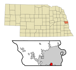
Ralston, Nebraska
City in Douglas County, Nebraska, United States
Distance: Approx. 1883 meters
Latitude and longitude: 41.20055556,-96.03555556
Ralston is a city in Douglas County, Nebraska, United States. The population was 6,494 at the 2020 census. A suburb of Omaha, Ralston is surrounded on three sides by the city of Omaha by 84th, 72nd, and L Streets, and by Sarpy County (Harrison Street) on the south side.

La Vista, Nebraska
City in Sarpy County, Nebraska, United States
Distance: Approx. 3277 meters
Latitude and longitude: 41.18138889,-96.06722222
La Vista is a city in Sarpy County, Nebraska, United States. The population was 16,746 at the 2020 census, making it the 12th most populous city in Nebraska. The city was incorporated on February 23, 1960.

Westside High School (Omaha)
Public school
Distance: Approx. 4241 meters
Latitude and longitude: 41.24722222,-96.05
Westside High School is the only high school of the Westside Community Schools district (also known as District 66 to local residents) of Omaha, Nebraska, United States.
Anime NebrasKon
Anime convention held in Omaha, Nebraska
Distance: Approx. 3482 meters
Latitude and longitude: 41.22786111,-96.02133333
Anime NebrasKon is an annual three-day anime convention held during October at the Mid-America Center in Council Bluffs, Iowa. It is organized by the Nebraska Japanese Animation Society.

Creighton University Medical Center - Bergan Mercy
Hospital in Nebraska, United States
Distance: Approx. 3911 meters
Latitude and longitude: 41.23945,-96.030811
Creighton University Medical Center - Bergan Mercy (formerly known as Creighton University Medical Center-Saint Joseph Hospital) is a hospital located in Central Omaha, Nebraska in the United States. On April 24, 2012, CUMC signed an agreement to be part of the Alegent Health System (now CHI Health) during the summer of 2012. The CUMC-Saint Joseph Hospital closed June 9, 2017 while simultaneously the academic medical center and trauma services opened at CHI Health Creighton University Medical Center – Bergan Mercy.
Fun-Plex
Amusement park in Omaha, Nebraska, United States
Distance: Approx. 2960 meters
Latitude and longitude: 41.20361111,-96.02027778
Fun-Plex is an amusement park located at 7003 Q Street in the Ralston neighborhood of Omaha, Nebraska. It is the largest amusement park in Nebraska, Fun-Plex began as “The Kart Ranch” in 1979 with just a go-kart track. In 2015 Fun-Plex is putting a brand new water feature called Makana Splash a water play structure with a 317-gallon bucket that drops water on you.
Ralston High School
Public school
Distance: Approx. 1021 meters
Latitude and longitude: 41.20055556,-96.05111111
Ralston High School (RHS) is located in Ralston, a suburb of Omaha, Nebraska, United States. The school, a part of Ralston Public Schools, opened in 1954 as a building for grades 7–12, located at 82nd and Lakeview Drive. It relocated to its current address on 8969 Park Drive in 1969.

Pipal Park
Distance: Approx. 3263 meters
Latitude and longitude: 41.23333333,-96.0325
Pipal Park is located at 7770 Hascall Street in southwest Omaha, Nebraska.
Beth El Cemetery
Jewish cemetery in Douglas County, Nebraska, USA
Distance: Approx. 925 meters
Latitude and longitude: 41.2112469,-96.0440593
The Beth El Cemetery is a Jewish cemetery located at 4700 South 84th Street (84th and "L" Streets) in Ralston, a city that is south of Omaha, Nebraska.
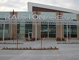
Liberty First Credit Union Arena
Sports and events arena in Nebraska
Distance: Approx. 2348 meters
Latitude and longitude: 41.20694444,-96.02694444
The Liberty First Credit Union Arena, formerly known as Ralston Arena and sometimes as Ralston Sports and Event Center, is an arena located in Ralston, Nebraska, a suburb of Omaha. It serves as the home of the Omaha Lancers of the United States Hockey League and the Omaha Beef of the National Arena League (NAL). It was home to the Omaha Mavericks NCAA Division I men's basketball team, representing the University of Nebraska Omaha, from its opening until the end of the 2014–15 season.
Portal, Nebraska
Community in Sarpy County, Nebraska, United States
Distance: Approx. 4264 meters
Latitude and longitude: 41.17638889,-96.08083333
Portal is an unincorporated community in Sarpy County, Nebraska, United States.
Tal Anderson Field
Baseball park in Nebraska
Distance: Approx. 4130 meters
Latitude and longitude: 41.234,-96.018
Tal Anderson Field is a college baseball park in the central United States, located in Omaha, Nebraska. It is the home field of the University of Nebraska Omaha Mavericks of the Summit League in NCAA Division I. Opened three years ago in 2021 in the Midtown neighborhood, it has a seating capacity of 1,500 for baseball. The artificial turf playing field is aligned northeast by north, at an approximate elevation of 1,030 feet (315 m) above sea level.
Weather in this IP's area
clear sky
13 Celsius
12 Celsius
11 Celsius
14 Celsius
1022 hPa
79 %
1022 hPa
983 hPa
10000 meters
2.57 m/s
150 degree
06:58:20
19:45:26