Country:
 Canada
Region:
City:
Latitude and Longitude:
Time Zone:
Postal Code:
IP information under different IP Channel
ip-api
Country
Region
City
ASN
Time Zone
ISP
Blacklist
Proxy
Latitude
Longitude
Postal
Route
IPinfo
Country
Region
City
ASN
Time Zone
ISP
Blacklist
Proxy
Latitude
Longitude
Postal
Route
MaxMind
Country
Region
City
ASN
Time Zone
ISP
Blacklist
Proxy
Latitude
Longitude
Postal
Route
Luminati
Country
CARegion
qc
City
actonvale
ASN
Time Zone
America/Toronto
ISP
CC-3272
Latitude
Longitude
Postal
db-ip
Country
Region
City
ASN
Time Zone
ISP
Blacklist
Proxy
Latitude
Longitude
Postal
Route
ipdata
Country
Region
City
ASN
Time Zone
ISP
Blacklist
Proxy
Latitude
Longitude
Postal
Route
Popular places and events near this IP address

Acton Regional County Municipality
Regional county municipality in Quebec, Canada
Distance: Approx. 425 meters
Latitude and longitude: 45.65,-72.56666667
Acton Regional County Municipality is a regional county municipality located in the Montérégie region of Quebec. The seat is Acton Vale. Founded in 1982, the Acton Regional County Municipality is made up of eight smaller municipalities containing a little fewer than 16,000 people.

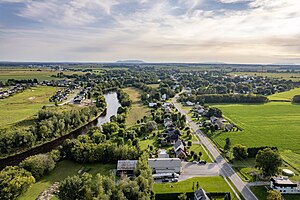
Acton Vale, Quebec
City in Quebec, Canada
Distance: Approx. 425 meters
Latitude and longitude: 45.65,-72.56666667
Acton Vale is an industrial town in south central Quebec, Canada. It is the seat of the Acton Regional County Municipality and is in the Montérégie administrative region. Its population in the Canada 2021 Census was 7,605.

Saint-Théodore-d'Acton
Municipality in Quebec, Canada
Distance: Approx. 3766 meters
Latitude and longitude: 45.68333333,-72.58333333
Saint-Théodore-d’Acton (Saint Theodore of Acton) is a municipality in the Regional County Municipality of Acton, in the province of Quebec, Canada. The population as of the Canada 2011 Census was 1,471. Within this municipality there is a small village, with the same name.
Upton, Quebec
Municipality in Quebec, Canada
Distance: Approx. 9384 meters
Latitude and longitude: 45.65,-72.68333333
Upton is a municipality in the Regional County Municipality of Acton, in the province of Quebec, Canada. The population as of the Canada 2011 Census was 2,075.
Johnson (electoral district)
Provincial electoral district in Quebec, Canada
Distance: Approx. 1065 meters
Latitude and longitude: 45.662,-72.566
Johnson is a provincial electoral district in 3 regions of Quebec, Canada that elects members to the National Assembly of Quebec. Centre-du-Québec (It includes part of the city of Drummondville, Saint-Germain-de-Grantham, Wickham) Montérégie (Acton Vale) Estrie (Roxton Pond, Sainte-Cécile-de-Milton). It was created for the 1973 election from parts of Bagot, Drummond, Richmond and Shefford electoral districts.
Bagot (provincial electoral district)
Provincial electoral district in Quebec, Canada
Distance: Approx. 7604 meters
Latitude and longitude: 45.7,-72.63333333
Bagot was a former provincial electoral district in the Estrie region of Quebec, Canada. It elected members to the National Assembly of Quebec (earlier known as the Legislative Assembly of Quebec). It was created for the 1867 election, and an electoral district of that name existed even earlier: see Bagot (Province of Canada).
CFID-FM
Community radio station in Acton Vale, Quebec
Distance: Approx. 2346 meters
Latitude and longitude: 45.63166667,-72.56472222
CFID-FM is a community radio radio station that broadcasts at 103.7 FM in Acton Vale, Quebec. Owned by Radio Acton, the station was licensed in 2004.
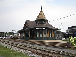
Acton Vale station
Railway station in Quebec, Canada
Distance: Approx. 493 meters
Latitude and longitude: 45.64833333,-72.56388889
Acton Vale station is a former railway station in Acton Vale, Quebec, Canada. The station was built in 1900 by the Grand Trunk Railway and is located at 960 Boulay Street. It was recognized as a National Historic Site of Canada on June 11, 1976.
Bagot (Province of Canada electoral district)
Provincial electoral district in Province of Canada, Canada
Distance: Approx. 7604 meters
Latitude and longitude: 45.7,-72.63333333
The district of Bagot was established in 1853, under the Union regime of 1841. Bagot was represented by one Member at the Legislative Assembly of the Province of Canada.
Jaune River (Noire River tributary)
River in Montérégie, Quebec, Canada
Distance: Approx. 5184 meters
Latitude and longitude: 45.60639,-72.55583
The Yellow River is a tributary of the Noire River. It flows in the municipalities of Roxton Falls and Acton Vale, in the Acton Regional County Municipality, in the administrative region of Montérégie, on the South Shore of St. Lawrence River, in Quebec, Canada.
Rivière le Renne
River in Estrie, Quebec, Canada
Distance: Approx. 7328 meters
Latitude and longitude: 45.68111,-72.64777
The rivière le Renne (English: Reindeer River) is a tributary of the Yamaska River, which flows in the municipalities of Maricourt, Sainte-Christine, Acton Vale, Saint-Nazaire-d'Acton, of Saint-Théodore-d'Acton, in the Acton Regional County Municipality (MRC), on the South Shore of the Saint Lawrence River, in Estrie, in Quebec, Canada.
Duncan River (rivière le Renne tributary)
River in Montérégie, Quebec, Canada
Distance: Approx. 9171 meters
Latitude and longitude: 45.65611,-72.68056
The Duncan River is a tributary of the rivière le Renne, which flows in the municipalities of Saint-Germain-de-Grantham (a sector of Drummondville), Saint-Nazaire-d'Acton, Saint-Théodore-d'Acton and Upton, in the Acton Regional County Municipality (MRC), in Montérégie, on the South Shore of the Saint Lawrence River, in Quebec, Canada.
Weather in this IP's area
clear sky
11 Celsius
10 Celsius
10 Celsius
12 Celsius
1032 hPa
76 %
1032 hPa
1020 hPa
10000 meters
2.5 m/s
2.48 m/s
209 degree
07:11:09
17:59:08