Country:
 USA
USARegion:
City:
Latitude and Longitude:
Time Zone:
Postal Code:
IP information under different IP Channel
ip-api
Country
Region
City
ASN
Time Zone
ISP
Blacklist
Proxy
Latitude
Longitude
Postal
Route
IPinfo
Country
Region
City
ASN
Time Zone
ISP
Blacklist
Proxy
Latitude
Longitude
Postal
Route
MaxMind
Country
Region
City
ASN
Time Zone
ISP
Blacklist
Proxy
Latitude
Longitude
Postal
Route
Luminati
Country
USRegion
hi
City
kalaheo
ASN
Time Zone
Pacific/Honolulu
ISP
TWC-20001-PACWEST
Latitude
Longitude
Postal
db-ip
Country
Region
City
ASN
Time Zone
ISP
Blacklist
Proxy
Latitude
Longitude
Postal
Route
ipdata
Country
Region
City
ASN
Time Zone
ISP
Blacklist
Proxy
Latitude
Longitude
Postal
Route
Popular places and events near this IP address
ʻEleʻele
Census-designated place in Hawaii, United States
Distance: Approx. 5752 meters
Latitude and longitude: 21.91055556,-159.58444444
ʻEleʻele (literally, "black" or "black water" in Hawaiian) is a census-designated place (CDP) on the island of Kauaʻi in Kauaʻi County, Hawaiʻi, United States, with the ZIP code of 96705. Glass Beach, that is made of sea glass, is a local attraction. The population was 2,515 at the 2020 census, up from 2,040 at the 2000 census.
Hanapepe, Hawaii
Place in Hawaii, United States
Distance: Approx. 6150 meters
Latitude and longitude: 21.91638889,-159.59027778
Hanapepe or Hanapēpē is a historic, unincorporated community in Kauai County, Hawaii, United States. The name means "crushed bay" in Hawaiian, which may refer to landslides in the area. For statistical purposes, the United States Census Bureau has defined Hanapepe as a census-designated place (CDP).

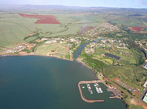
Kalaheo, Hawaii
Census-designated place in Hawaii, United States
Distance: Approx. 500 meters
Latitude and longitude: 21.92444444,-159.52944444
Kalāheo (literally, "the proud day" in Hawaiian) is an unincorporated community and census-designated place (CDP) in Kauaʻi County, island of Kauaʻi, Hawaiʻi, United States. The population was 4,996 at the 2020 census, up from 3,913 at the 2000 census. The National Tropical Botanical Garden is located in Kalāheo.

Lawai, Hawaii
Census-designated place in Hawaii, United States
Distance: Approx. 2561 meters
Latitude and longitude: 21.92527778,-159.5075
Lāwaʻi is a census-designated place (CDP) in Kauaʻi County in the U.S. state of Hawaiʻi. The population was 2,578 at the 2020 census, up from 1,984 at the 2000 census.

ʻŌmaʻo, Hawaii
Census-designated place in Hawaii, United States
Distance: Approx. 5293 meters
Latitude and longitude: 21.91972222,-159.48166667
ʻŌmaʻo (literally, "green" in Hawaiian) is a census-designated place (CDP) in Kauaʻi County, Hawaiʻi, United States. The population was 1,346 at the 2020 census.

National Tropical Botanical Garden
Nonprofit organization in United States of America
Distance: Approx. 3232 meters
Latitude and longitude: 21.90666667,-159.51111111
The National Tropical Botanical Garden (NTBG) is a Hawaii-based not-for-profit institution dedicated to tropical plant research, conservation, and education. It operates a network of botanical gardens and preserves in Hawaii and Florida.
Hanapepe massacre
Interethnic dispute in Kauaʻi, Hawaiʻi (1924)
Distance: Approx. 4157 meters
Latitude and longitude: 21.9005,-159.5591
The Hanapēpē Massacre (also called the Battle of Hanapēpē) occurred on September 9, 1924, when an dispute amongst Filipino strike organizers in Hanapēpē, Kaua'i resulted in a violent exchange between local police officers and Filipinos. The conflict began when two Ilocano youth, allegedly breaking the Filipino-led labor strike, were detained and harassed by a group of Visayans at the Hanapepe strike camp. When the local police were called to settle the dispute, they arrived with a group of heavily armed special deputies.
Allerton Garden
Botanical garden located in Kauai, Hawaii, United States
Distance: Approx. 6250 meters
Latitude and longitude: 21.88574167,-159.49251111
Allerton Garden, also known as Lāwaʻi-kai, is a botanical garden, originally created by Robert Allerton and John Gregg Allerton, located on the south shore of Kauai, Hawaii. The garden covers an 80-acre (320,000 m2) area and is situated beside the Lāwaʻi Bay, in a valley transected by the Lāwaʻi Stream. It is one of the five gardens of the non-profit National Tropical Botanical Garden.
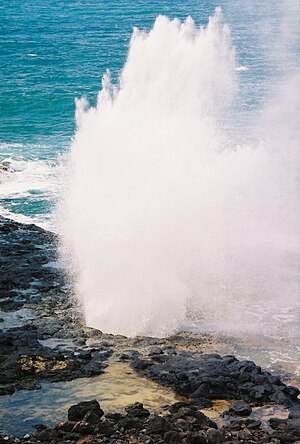
Spouting Horn
Blowhole on Kauai, Hawaii
Distance: Approx. 6240 meters
Latitude and longitude: 21.885018,-159.493581
Spouting Horn is a blowhole located on the southern coast of Kauai in the Koloa district. This area of Kauai is known for its crashing waves (nearby Poipu translates to "crashing"). These waves erode lava rocks on the coastline which can create narrow openings, as is the case with Spouting Horn.

Glass Beach (ʻEleʻele, Hawaii)
Distance: Approx. 6314 meters
Latitude and longitude: 21.89805556,-159.58388889
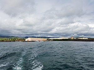
Glass Beach is a beach in ʻEleʻele, an industrial area in Kauai, Hawaii, that is made of sea glass. It is in Hanapepe Bay, near Port Allen Harbor. The beach's regular rock is basalt, but the sea glass formed after years of discarded glass.

Hanapepe Town Lot No. 18
Historic place in Hawaii, United States
Distance: Approx. 5939 meters
Latitude and longitude: 21.911452,-159.586704
Hanapepe Town Lot No. 18, Hanapepe, Hawaii, on the island of Kauai, is a building built in 1926. Historically remembered as the Pool Hall, it was built as a coffee shop, then later partly used as a radio shop.
Kōʻula River
River in Hawaii, United States
Distance: Approx. 3550 meters
Latitude and longitude: 21.95511,-159.55054
The Kō'ula River or Koula is the largest tributary of the Hanapēpē River on the Hawaiian island of Kauai. It rises at 4,642 ft (1415 meters) on the slopes of Mt. Waialeale and flows generally south for 9.2 miles to its confluence with the Manuahi Stream.
Weather in this IP's area
clear sky
24 Celsius
24 Celsius
22 Celsius
25 Celsius
1019 hPa
80 %
1019 hPa
994 hPa
10000 meters
4.98 m/s
7.3 m/s
36 degree
1 %
06:31:45
18:18:52