24.39.111.81 - IP Lookup: Free IP Address Lookup, Postal Code Lookup, IP Location Lookup, IP ASN, Public IP
Country:
Region:
City:
Location:
Time Zone:
Postal Code:
IP information under different IP Channel
ip-api
Country
Region
City
ASN
Time Zone
ISP
Blacklist
Proxy
Latitude
Longitude
Postal
Route
Luminati
Country
Region
ny
City
newyork
ASN
Time Zone
America/New_York
ISP
TWC-12271-NYC
Latitude
Longitude
Postal
IPinfo
Country
Region
City
ASN
Time Zone
ISP
Blacklist
Proxy
Latitude
Longitude
Postal
Route
IP2Location
24.39.111.81Country
Region
new york
City
manhattan
Time Zone
America/New_York
ISP
Language
User-Agent
Latitude
Longitude
Postal
db-ip
Country
Region
City
ASN
Time Zone
ISP
Blacklist
Proxy
Latitude
Longitude
Postal
Route
ipdata
Country
Region
City
ASN
Time Zone
ISP
Blacklist
Proxy
Latitude
Longitude
Postal
Route
Popular places and events near this IP address
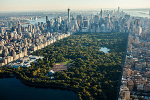
Central Park
Public park in Manhattan, New York
Distance: Approx. 152 meters
Latitude and longitude: 40.78222222,-73.96527778
Central Park is an urban park between the Upper West Side and Upper East Side neighborhoods of Manhattan in New York City, and the first landscaped park in the United States. It is the sixth-largest park in the city, containing 843 acres (341 ha), and the most visited urban park in the United States, with an estimated 42 million visitors annually as of 2016. It is also one of the most filmed locations in the world.
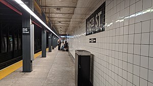
86th Street station (IND Eighth Avenue Line)
New York City Subway station in Manhattan
Distance: Approx. 336 meters
Latitude and longitude: 40.785286,-73.969316
The 86th Street station is a local station on the IND Eighth Avenue Line of the New York City Subway. Located at Central Park West and 86th Street on the Upper West Side, it is served by the B on weekdays, the C train at all times except nights, and the A train during late nights only.
Seneca Village
Former settlement in Manhattan, New York
Distance: Approx. 237 meters
Latitude and longitude: 40.784002,-73.968892
Seneca Village was a 19th-century settlement of mostly African American landowners in the borough of Manhattan in New York City, within what would become present-day Central Park. The settlement was located near the current Upper West Side neighborhood, approximately bounded by Central Park West and the axes of 82nd Street, 89th Street, and Seventh Avenue, had they been constructed through the park. Seneca Village was founded in 1825 by free Black Americans, the first such community in the city, although under Dutch rule there was a "half-free" community of African-owned farms north of New Amsterdam.
Central Park Conservancy
Nonprofit park conservancy
Distance: Approx. 152 meters
Latitude and longitude: 40.78222222,-73.96527778
The Central Park Conservancy is an American private, nonprofit park conservancy that manages New York City's Central Park under a contract with the government of New York City and NYC Parks. The conservancy employs most maintenance and operations staff in the park. It effectively oversees the work of both the private and public employees under the authority of the publicly appointed Central Park administrator, who reports to the parks commissioner and the conservancy's president.

Diana Ross Playground
Playground in Central Park, New York City
Distance: Approx. 422 meters
Latitude and longitude: 40.7822725,-73.97097429
The Diana Ross Playground is located in New York City's Central Park, inside the park at West 81st Street and Central Park West.
City Congregation for Humanistic Judaism
Jewish congregation in New York City
Distance: Approx. 417 meters
Latitude and longitude: 40.7858,-73.97
The City Congregation for Humanistic Judaism (shortened to The City Congregation or TCC) is a Humanistic Jewish congregation and synagogue meeting in the Upper West Side neighborhood of Manhattan in New York City, New York, United States. It is the first Humanistic congregation in New York City to be led by a Humanistic rabbi.
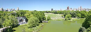
Great Lawn and Turtle Pond
Geographical features in New York City's Central Park
Distance: Approx. 229 meters
Latitude and longitude: 40.78135,-73.96648
The Great Lawn and Turtle Pond are two connected features of Central Park in Manhattan, New York City, United States. The lawn and pond are located on the site of a former reservoir for the Croton Aqueduct system which was infilled during the early 20th century. The pond, originally known as Belvedere Lake, abuts Belvedere Castle as well as the Delacorte Theater, and contains a variety of turtles and fish.

Central Park West Historic District
Historic district in Manhattan, New York
Distance: Approx. 297 meters
Latitude and longitude: 40.78444444,-73.96944444
The Central Park West Historic District is located along Central Park West, between 61st and 97th Streets, on the Upper West Side of Manhattan in New York City, United States. The district was added to the National Register of Historic Places on November 9, 1982. The district encompasses a portion of the Upper West Side-Central Park West Historic District as designated by the New York City Landmarks Preservation Commission, and contains a number of prominent New York City designated landmarks, including the Dakota, a National Historic Landmark.

Central Park Hospital
Hospital in New York, United States
Distance: Approx. 268 meters
Latitude and longitude: 40.781,-73.966
The Central Park Hospital (officially the U.S. General Hospital, Central Park) was a military hospital that operated in New York City during the American Civil War, from 1862 to 1865. It occupied the former grounds of Mount St. Vincent's Academy near 102nd St and East Drive in Central Park, just west of Fifth Avenue and atop the Revolutionary War site of McGowan's Pass.
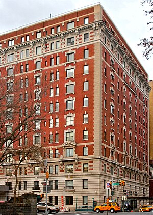
257 Central Park West
Co-op apartment building in Manhattan, New York
Distance: Approx. 346 meters
Latitude and longitude: 40.785,-73.96972222
257 Central Park West (also known as the Orwell House) is a co-op apartment building on the southwest corner of 86th Street and Central Park West in the Upper West Side of Manhattan in New York City. It was designed by the firm of Mulliken and Moeller and built by Gotham Building & Construction between 1905 and 1906. The structure was constructed as a luxury apartment house originally called the Central Park View.
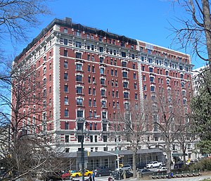
Rossleigh Court
Apartment building in Manhattan, New York
Distance: Approx. 352 meters
Latitude and longitude: 40.78472222,-73.97
Rossleigh Court, constructed between 1906 and 1907, currently is a rental apartment building located on the northwest corner of 85th Street and Central Park West in the Upper West Side of Manhattan in New York City. Like the similarly designed and adjoining building to its north, 257 Central Park West, Rossleigh Court was designed by Mulliken and Moeller and built by Gotham Building and Construction. Opening one year after its "twin" to the north, both buildings followed the popular "French Flat" model in a Beaux-Arts style.

Statue of Alexander Hamilton (Central Park)
Statue by Carl Conrads in Central Park, Manhattan, New York, U.S.
Distance: Approx. 298 meters
Latitude and longitude: 40.78102778,-73.96455556
An outdoor granite sculpture of Alexander Hamilton by Carl Conrads is installed in Central Park, Manhattan, New York. Hamilton's son, John C. Hamilton, commissioned Conrads to sculpt this statue, which was dedicated on November 22, 1880, and donated to the city. Conrads used the bust of Hamilton created by the sculptor Giuseppe Ceracchi as a model for Hamilton's head.
Weather in this IP's area
few clouds
3 Celsius
-2 Celsius
2 Celsius
4 Celsius
1011 hPa
63 %
1011 hPa
1007 hPa
10000 meters
7.2 m/s
12.35 m/s
250 degree
20 %