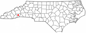
Country:
 USA
USARegion:
City:
Latitude and Longitude:
Time Zone:
Postal Code:
IP information under different IP Channel
ip-api
Country
Region
City
ASN
Time Zone
ISP
Blacklist
Proxy
Latitude
Longitude
Postal
Route
IPinfo
Country
Region
City
ASN
Time Zone
ISP
Blacklist
Proxy
Latitude
Longitude
Postal
Route
MaxMind
Country
Region
City
ASN
Time Zone
ISP
Blacklist
Proxy
Latitude
Longitude
Postal
Route
Luminati
Country
USRegion
nc
City
hendersonville
ASN
Time Zone
America/New_York
ISP
MORRISBB
Latitude
Longitude
Postal
db-ip
Country
Region
City
ASN
Time Zone
ISP
Blacklist
Proxy
Latitude
Longitude
Postal
Route
ipdata
Country
Region
City
ASN
Time Zone
ISP
Blacklist
Proxy
Latitude
Longitude
Postal
Route
Popular places and events near this IP address

Balfour, North Carolina
Census-designated place in North Carolina, United States
Distance: Approx. 7219 meters
Latitude and longitude: 35.34944444,-82.4825
Balfour is an unincorporated community and census-designated place (CDP) in Henderson County, North Carolina, United States. The population was 1,187 at the 2010 census. It is part of the Asheville Metropolitan Statistical Area.
Fletcher, North Carolina
Town in North Carolina, United States
Distance: Approx. 6547 meters
Latitude and longitude: 35.43166667,-82.50388889
Fletcher is a town in Henderson County, North Carolina, United States. The population was 7,187 at the 2010 census, and was estimated to be 8,333 in 2018. Fletcher is adjacent to Asheville Regional Airport, which serves western North Carolina.
Mountain Home, North Carolina
Census-designated place in North Carolina, United States
Distance: Approx. 4515 meters
Latitude and longitude: 35.37083333,-82.50222222
Mountain Home is an unincorporated community and census-designated place (CDP) in Henderson County, North Carolina, United States. The population was 3,622 at the 2010 census, up from 2,169 in 2000. It is part of the Asheville Metropolitan Statistical Area.

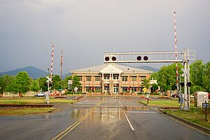
Asheville Regional Airport
Airport located in Fletcher, North Carolina, USA
Distance: Approx. 5669 meters
Latitude and longitude: 35.43611111,-82.54166667
Asheville Regional Airport (IATA: AVL, ICAO: KAVL, FAA LID: AVL) is a Class C airport near Interstate 26 and the town of Fletcher, North Carolina, 9 miles (14 km) south of downtown Asheville. It is owned by the Greater Asheville Regional Airport Authority. The Federal Aviation Administration (FAA) National Plan of Integrated Airport Systems for 2019–2023 categorized it as a small-hub primary commercial service facility.
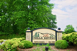
Mills River, North Carolina
Town in North Carolina, United States
Distance: Approx. 3329 meters
Latitude and longitude: 35.38527778,-82.58527778
Mills River is a town in Henderson County, North Carolina, United States. The population was 6,802 at the 2010 census, and was estimated to be 7,406 in 2019. The town took its name from the nearby confluence of the Mills River and French Broad River.
Mills River (North Carolina)
River in North Carolina
Distance: Approx. 1551 meters
Latitude and longitude: 35.38861111,-82.53194444
The Mills River is located in Transylvania and Henderson counties, North Carolina, United States is a tributary of the French Broad River. The river flows out of the Pisgah Ranger District of the Pisgah National Forest in two forks: the North Fork, which drains the slopes just south of the Blue Ridge Parkway between Asheville and Mount Pisgah, and the South Fork, which drains the area of the Pisgah Ranger District just east of the Cradle of Forestry in America, including the slopes of Black Mountain. The Mills River flows into the French Broad River northwest of Hendersonville between NC 191 and Interstate 26.

Mills River Chapel
United States historic place
Distance: Approx. 2625 meters
Latitude and longitude: 35.38444444,-82.5775
Mills River Chapel, also known as Mills River United Methodist Church, is a historic Methodist chapel located near Mills River, Henderson County, North Carolina. It was built in 1860–1861, and is a one-story, rectangular, vernacular Greek Revival-style church. It features a front portico with four, square, recessed panel wooden columns.

Rugby Grange
Historic house in North Carolina, United States
Distance: Approx. 4671 meters
Latitude and longitude: 35.42083333,-82.52083333
The Rugby Grange, near Fletcher, Henderson County, North Carolina, was built in 1860 in Italianate architecture. The property includes agricultural outbuildings, agricultural fields and secondary structure, a total of 12 contributing buildings and one other contributing site. They include Rugby Lodge II, the "Big House", the Cottage, the Shanty, Uncle Martin's and Uncle Billy's cabins, the ice house, and several barns.
Horse Shoe, North Carolina
Census-designated place in North Carolina, United States
Distance: Approx. 4877 meters
Latitude and longitude: 35.34222222,-82.55694444
Horse Shoe is an unincorporated community and census-designated place (CDP) in Henderson County, North Carolina, United States. Its ZIP code is 28742. As of the 2010 census, its population was 2,351.
Naples, North Carolina
Unincorporated community in North Carolina, United States
Distance: Approx. 4429 meters
Latitude and longitude: 35.3925,-82.50055556
Naples is an unincorporated community in Henderson County, North Carolina, United States and is part of the Asheville Metropolitan Statistical Area. It is located near U.S. Route 25 Business (US 25 Bus.) and Interstate 26 (I-26) exit 44.
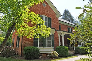
Moss–Johnson Farm
Historic farm in North Carolina, United States
Distance: Approx. 4627 meters
Latitude and longitude: 35.35944444,-82.50888889
Moss–Johnson Farm, also known as the Johnson Farm, is a historic farm complex located near Hendersonville, Henderson County, North Carolina, United States. The farmhouse was built between 1874 and 1880, and is a rectangular brick dwelling measuring 50 feet by 28 feet. Also on the property are the contributing clapboard summer house (1920), a granary and smokehouse (1880), a well, a barn (1923), a small dwelling (1933), and a hen house and pig barn.

AdventHealth Hendersonville
Hospital in North Carolina, United States
Distance: Approx. 5492 meters
Latitude and longitude: 35.39,-82.48833333
AdventHealth Hendersonville is a non-profit hospital campus in Hendersonville, North Carolina owned by AdventHealth.
Weather in this IP's area
overcast clouds
25 Celsius
26 Celsius
23 Celsius
27 Celsius
1012 hPa
67 %
1012 hPa
943 hPa
10000 meters
1.54 m/s
100 %
07:16:18
19:31:25