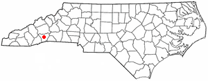
Country:
 USA
USARegion:
City:
Latitude and Longitude:
Time Zone:
Postal Code:
IP information under different IP Channel
ip-api
Country
Region
City
ASN
Time Zone
ISP
Blacklist
Proxy
Latitude
Longitude
Postal
Route
IPinfo
Country
Region
City
ASN
Time Zone
ISP
Blacklist
Proxy
Latitude
Longitude
Postal
Route
MaxMind
Country
Region
City
ASN
Time Zone
ISP
Blacklist
Proxy
Latitude
Longitude
Postal
Route
Luminati
Country
USRegion
nc
City
horseshoe
ASN
Time Zone
America/New_York
ISP
MORRISBB
Latitude
Longitude
Postal
db-ip
Country
Region
City
ASN
Time Zone
ISP
Blacklist
Proxy
Latitude
Longitude
Postal
Route
ipdata
Country
Region
City
ASN
Time Zone
ISP
Blacklist
Proxy
Latitude
Longitude
Postal
Route
Popular places and events near this IP address

Balfour, North Carolina
Census-designated place in North Carolina, United States
Distance: Approx. 6958 meters
Latitude and longitude: 35.34944444,-82.4825
Balfour is an unincorporated community and census-designated place (CDP) in Henderson County, North Carolina, United States. The population was 1,187 at the 2010 census. It is part of the Asheville Metropolitan Statistical Area.

Etowah, North Carolina
Census-designated place in Henderson County, North Carolina, USA
Distance: Approx. 5253 meters
Latitude and longitude: 35.30611111,-82.59027778
Etowah is an unincorporated community and census-designated place (CDP) in Henderson County, North Carolina, United States. The population was 6,944 at the 2010 census. It is part of the Asheville Metropolitan Statistical Area.

Laurel Park, North Carolina
Town in North Carolina, United States
Distance: Approx. 6284 meters
Latitude and longitude: 35.31166667,-82.50388889
Laurel Park is a town in Henderson County, North Carolina, United States. The population was 2,250 at the 2020 census. It is part of the Asheville Metropolitan Statistical Area.
Mountain Home, North Carolina
Census-designated place in North Carolina, United States
Distance: Approx. 5860 meters
Latitude and longitude: 35.37083333,-82.50222222
Mountain Home is an unincorporated community and census-designated place (CDP) in Henderson County, North Carolina, United States. The population was 3,622 at the 2010 census, up from 2,169 in 2000. It is part of the Asheville Metropolitan Statistical Area.
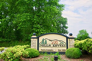
Mills River, North Carolina
Town in North Carolina, United States
Distance: Approx. 5000 meters
Latitude and longitude: 35.38527778,-82.58527778
Mills River is a town in Henderson County, North Carolina, United States. The population was 6,802 at the 2010 census, and was estimated to be 7,406 in 2019. The town took its name from the nearby confluence of the Mills River and French Broad River.
Mills River (North Carolina)
River in North Carolina
Distance: Approx. 5361 meters
Latitude and longitude: 35.38861111,-82.53194444
The Mills River is located in Transylvania and Henderson counties, North Carolina, United States is a tributary of the French Broad River. The river flows out of the Pisgah Ranger District of the Pisgah National Forest in two forks: the North Fork, which drains the slopes just south of the Blue Ridge Parkway between Asheville and Mount Pisgah, and the South Fork, which drains the area of the Pisgah Ranger District just east of the Cradle of Forestry in America, including the slopes of Black Mountain. The Mills River flows into the French Broad River northwest of Hendersonville between NC 191 and Interstate 26.

Mills River Chapel
United States historic place
Distance: Approx. 4618 meters
Latitude and longitude: 35.38444444,-82.5775
Mills River Chapel, also known as Mills River United Methodist Church, is a historic Methodist chapel located near Mills River, Henderson County, North Carolina. It was built in 1860–1861, and is a one-story, rectangular, vernacular Greek Revival-style church. It features a front portico with four, square, recessed panel wooden columns.
Horse Shoe, North Carolina
Census-designated place in North Carolina, United States
Distance: Approx. 440 meters
Latitude and longitude: 35.34222222,-82.55694444
Horse Shoe is an unincorporated community and census-designated place (CDP) in Henderson County, North Carolina, United States. Its ZIP code is 28742. As of the 2010 census, its population was 2,351.
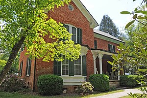
Moss–Johnson Farm
Historic farm in North Carolina, United States
Distance: Approx. 4797 meters
Latitude and longitude: 35.35944444,-82.50888889
Moss–Johnson Farm, also known as the Johnson Farm, is a historic farm complex located near Hendersonville, Henderson County, North Carolina, United States. The farmhouse was built between 1874 and 1880, and is a rectangular brick dwelling measuring 50 feet by 28 feet. Also on the property are the contributing clapboard summer house (1920), a granary and smokehouse (1880), a well, a barn (1923), a small dwelling (1933), and a hen house and pig barn.

Singletary-Reese-Robinson House
Historic house in North Carolina, United States
Distance: Approx. 6702 meters
Latitude and longitude: 35.31055556,-82.49916667
Singletary-Reese-Robinson House, also known as Woodlawn, is a historic home located at Laurel Park, Henderson County, North Carolina. It was built in 1912, and is a two-story, "L"-form, Rustic Revival style log dwelling. It has a two-story rear wing addition and features a hip-roof wraparound porch.
Bryn Avon
Historic house in North Carolina, United States
Distance: Approx. 5569 meters
Latitude and longitude: 35.29666667,-82.57055556
Bryn Avon is a historic estate and national historic district located near Etowah, Henderson County, North Carolina. Bryn Avon house was built about 1884-1886 and updated in the 1910-1920s in the Tudor Revival style. It is a 1+1⁄2-story, stone and half-timbered manor house.
Bowman Bluff, North Carolina
Unincorporated community in North Carolina, US
Distance: Approx. 4703 meters
Latitude and longitude: 35.30361111,-82.56166667
Bowman Bluff is an unincorporated community in Henderson County, in the U.S. state of North Carolina.
Weather in this IP's area
overcast clouds
25 Celsius
26 Celsius
23 Celsius
27 Celsius
1012 hPa
67 %
1012 hPa
943 hPa
10000 meters
1.54 m/s
100 %
07:16:21
19:31:27