Country:
 USA
USARegion:
City:
Latitude and Longitude:
Time Zone:
Postal Code:
IP information under different IP Channel
ip-api
Country
Region
City
ASN
Time Zone
ISP
Blacklist
Proxy
Latitude
Longitude
Postal
Route
IPinfo
Country
Region
City
ASN
Time Zone
ISP
Blacklist
Proxy
Latitude
Longitude
Postal
Route
MaxMind
Country
Region
City
ASN
Time Zone
ISP
Blacklist
Proxy
Latitude
Longitude
Postal
Route
Luminati
Country
USRegion
ca
City
rialto
ASN
Time Zone
America/Los_Angeles
ISP
TWC-20001-PACWEST
Latitude
Longitude
Postal
db-ip
Country
Region
City
ASN
Time Zone
ISP
Blacklist
Proxy
Latitude
Longitude
Postal
Route
ipdata
Country
Region
City
ASN
Time Zone
ISP
Blacklist
Proxy
Latitude
Longitude
Postal
Route
Popular places and events near this IP address

Rialto, California
City in California, United States
Distance: Approx. 412 meters
Latitude and longitude: 34.11138889,-117.3825
Rialto is a city in San Bernardino County, California, United States, 56 miles east of Los Angeles, near the Cajon Pass, Interstate 15, Interstate 10, State Route 210 and Metrolink routes. Its population was 104,026 as of the 2020 Census, up from 99,171 at the 2010 Census. Its population and economic activity have grown rapidly in recent years due to the building of major distribution centers in the region.
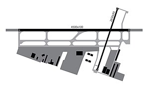
Rialto Municipal Airport
Former general aviation airport in Rialto, California
Distance: Approx. 2280 meters
Latitude and longitude: 34.12944444,-117.40166667
Rialto Municipal Airport (FAA LID: L67), originally Miro Field, was a general aviation airport three miles (5 km) northwest of Rialto, in San Bernardino County, California, United States. It was used by private aircraft; no airlines flew into this airport. It was about 12 miles northeast of Ontario International Airport and ten miles west of San Bernardino International Airport.
California's 31st congressional district
U.S. House district for California
Distance: Approx. 2920 meters
Latitude and longitude: 34.11,-117.35333333
California's 31st congressional district is a congressional district in Los Angeles County, in the U.S. state of California. The district is located in the San Gabriel Valley. From January 3, 2023, following the 2020 redistricting cycle, the district is currently represented by Democrat Grace Napolitano.

San Bernardino train disaster
1989 train crash and subsequent oil pipeline rupture in California
Distance: Approx. 4501 meters
Latitude and longitude: 34.1375,-117.34416667
The San Bernardino train disaster (sometimes known as the Duffy Street incident), was a combination of two separate but related incidents that occurred in San Bernardino, California, United States: a runaway train derailment on May 12, 1989; and the subsequent failure on May 25, 1989, of the Calnev Pipeline, a petroleum pipeline adjacent to the tracks which was damaged by earth-moving equipment during the crash cleanup.
Eisenhower High School (Rialto, California)
High school in California, United States
Distance: Approx. 1143 meters
Latitude and longitude: 34.12361111,-117.37833333
Dwight D. Eisenhower High School (est. 1959), is located in Rialto, California, United States on the corner of Baseline Avenue and Lilac Ave. The school is named for U.S. President Dwight D. Eisenhower.
Rialto High School
Public high school in Rialto, California
Distance: Approx. 3667 meters
Latitude and longitude: 34.09138889,-117.35638889
Rialto High School is a public high school located in San Bernardino, California, with a Rialto postal address. that opened in September 1992. It is operated by the Rialto Unified School District, and is a member of the San Andreas.
Wilmer Amina Carter High School
Public high school in Rialto, California
Distance: Approx. 4080 meters
Latitude and longitude: 34.148,-117.403
Wilmer Amina Carter High School is a high school located in Rialto, California, United States.

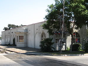
Rialto station
Distance: Approx. 2252 meters
Latitude and longitude: 34.0969,-117.3729
Rialto station (also known as the John Longville Depot) is a Metrolink San Bernardino Line station located at 292 South Palm Avenue in Rialto, in San Bernardino County, California, just south of Rialto Avenue off of Riverside Avenue. The station is named for former Assemblymember and Rialto Mayor John Longville. The station is owned by the city of Rialto and was designed as a replica of the former 1888-built Atchison, Topeka and Santa Fe Railway frame-built structure.

First Christian Church of Rialto
Historic church in California, United States
Distance: Approx. 1939 meters
Latitude and longitude: 34.10277778,-117.36916667
First Christian Church of Rialto is a historic church located at 201 N. Riverside Avenue in Rialto, California. The church was built from 1906 to 1907 to serve Rialto's First Christian Church, which was founded in 1905. Architect H. M. Patterson designed the church in the Late Gothic Revival style; his design also features elements of the American Craftsman style.
Lytle Creek Wash
Distance: Approx. 4778 meters
Latitude and longitude: 34.10777778,-117.33333333
Lytle Creek Wash is the middle reach of Lytle Creek in San Bernardino County, California.
Cajon Wash
Stream in San Bernardino County, California, US
Distance: Approx. 4092 meters
Latitude and longitude: 34.14277778,-117.35583333
Cajon Wash is a tributary of Lytle Creek in San Bernardino County, California.
Rialto station (Pacific Electric)
Distance: Approx. 1995 meters
Latitude and longitude: 34.10138,-117.37002
Rialto station was a Pacific Electric train station in Rialto, California. It is located on Riverside Avenue at crossing of the Union Pacific (formerly Pacific Electric and Southern Pacific) tracks. This was the point where the Riverside–Rialto Line branched south from the Upland–San Bernardino Line.
Weather in this IP's area
clear sky
34 Celsius
33 Celsius
32 Celsius
36 Celsius
1008 hPa
28 %
1008 hPa
964 hPa
10000 meters
4.12 m/s
270 degree
06:27:45
19:07:19