Country:
 USA
USARegion:
City:
Latitude and Longitude:
Time Zone:
Postal Code:
IP information under different IP Channel
ip-api
Country
Region
City
ASN
Time Zone
ISP
Blacklist
Proxy
Latitude
Longitude
Postal
Route
IPinfo
Country
Region
City
ASN
Time Zone
ISP
Blacklist
Proxy
Latitude
Longitude
Postal
Route
MaxMind
Country
Region
City
ASN
Time Zone
ISP
Blacklist
Proxy
Latitude
Longitude
Postal
Route
Luminati
Country
USRegion
ca
City
lakeelsinore
ASN
Time Zone
America/Los_Angeles
ISP
TWC-20001-PACWEST
Latitude
Longitude
Postal
db-ip
Country
Region
City
ASN
Time Zone
ISP
Blacklist
Proxy
Latitude
Longitude
Postal
Route
ipdata
Country
Region
City
ASN
Time Zone
ISP
Blacklist
Proxy
Latitude
Longitude
Postal
Route
Popular places and events near this IP address
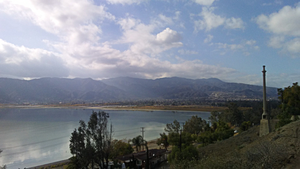
Lake Elsinore, California
City in California, United States
Distance: Approx. 2422 meters
Latitude and longitude: 33.68138889,-117.34527778
Lake Elsinore is a city in western Riverside County, California, United States. Established as a city in 1888, it is on the shore of Lake Elsinore, a natural freshwater lake about 3,000 acres (1,200 ha) in size. The city has grown from a small resort town in the late 19th and early 20th centuries to a suburban city with over 70,000 residents.

Lakeland Village, California
Census-designated place in California, United States
Distance: Approx. 2397 meters
Latitude and longitude: 33.63861111,-117.34388889
Lakeland Village is a census-designated place (CDP) in Riverside County, California, United States. The population was 11,541 at the 2010 census, more than double the 5,626 reported at the 2000 census.

Lake Elsinore
Lake in Riverside County, California
Distance: Approx. 94 meters
Latitude and longitude: 33.65916667,-117.34916667
Lake Elsinore is a natural freshwater lake in Riverside County, California, United States, located east of the Santa Ana Mountains and fed by the San Jacinto River. Originally named Laguna Grande by Spanish explorers, it was renamed for the town of Elsinore, established on its northeastern shore on April 9, 1888. Lake water levels have fluctuated greatly from dry spells to flooding.

Lake Elsinore Diamond
Stadium in California
Distance: Approx. 4359 meters
Latitude and longitude: 33.65416667,-117.30194444
Lake Elsinore Diamond, also referred to as Storm Stadium, is a baseball park in Lake Elsinore, California. It is primarily used for baseball and is the home field of the Lake Elsinore Storm minor league baseball team in the California League. The field at Diamond Stadium is named Pete Lehr Field.

San Jacinto River (California)
River in California, United States
Distance: Approx. 3484 meters
Latitude and longitude: 33.64585,-117.31483889
The San Jacinto River is a 42-mile-long (68 km) river in Riverside County, California. The river's headwaters are in Santa Rosa and San Jacinto Mountains National Monument. The lower portion of the 765-square-mile (1,980 km2) watershed is urban and agricultural land.
Lakeside High School (Lake Elsinore, California)
Public (u.s.) school in the United States
Distance: Approx. 3239 meters
Latitude and longitude: 33.67027778,-117.38111111
Lakeside High School is a public high school located in Lake Elsinore, California and is part of the Lake Elsinore Unified School District. Lakeside High School has been rated as one of the top 10 most beautiful high school campuses in California.
Butterfield Elementary School (Lake Elsinore, California)
Public school in Lake Elsinore, California, United States
Distance: Approx. 1918 meters
Latitude and longitude: 33.6506,-117.366
Butterfield Elementary School was a publicly funded grade school in the Lake Elsinore Unified School District, in California, USA. It was named after the old Butterfield Overland Stage route which runs in front of the school. It provided many innovative programs to its students. In 1995, Butterfield became the new home of the first Elementary Visual and Performing Arts (VAPA) Magnet School Program in Riverside County (its first home had been Elsinore Elementary School).
Rancho La Laguna
Distance: Approx. 2209 meters
Latitude and longitude: 33.64,-117.35
Rancho La Laguna was a 13,339-acre (53.98 km2) Mexican land grant in present-day Riverside County, California given in 1844 by Governor Manuel Micheltorena to Julian Manriquez. The rancho lands are included in the present day city of Lake Elsinore and Wildomar. At the time of the US Patent, Rancho Laguna was a part of San Diego County.

Elsinore Trough
Distance: Approx. 3114 meters
Latitude and longitude: 33.68333333,-117.36666667
The Elsinore Trough is a graben rift valley in Riverside County, southern California. It is created by the Elsinore Fault Zone. It is located between the Santa Ana Mountains to the west, and the Temescal Mountains of the Perris Block and the Temecula Basin to the east.

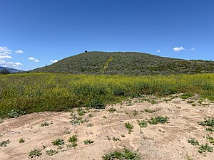
Clevelin Hills
Range of hills in California
Distance: Approx. 2326 meters
Latitude and longitude: 33.68055556,-117.35138889
The Clevelin Hills are a range of hills in the Peninsular Ranges System, within the Temescal Mountains in western Riverside County, in southern California. The hills range from an elevation of over 1,400 feet (430 m) in the southeastern section, to the range's high point of 1,835 feet (559 m) in elevation, in the northwestern section. The Clevelin Hills are named for the leading developers of the Clevelin Corporation (Henry Cleveland Schultz and Abe Corlinsky) in the 1920s.
Rome Hill
Hill near Lake Elsinore
Distance: Approx. 4007 meters
Latitude and longitude: 33.63138889,-117.32194444
Rome Hill, also called St. Davids Hill, is a small summit at the southwest corner of Lake Elsinore. It lies at an elevation of 1,444 feet/440 meters.

Elsinore Naval and Military School
Military school, boarding school in Lake Elsinore, California, California, United States
Distance: Approx. 2306 meters
Latitude and longitude: 33.6576833,-117.3732556
Elsinore Naval and Military School was a military boarding school in California. It was built in 1924, and was originally intended to be the "Southern California Athletic and Country Club", catering to the wealthy and famous personalities who frequented Lake Elsinore in the 1920s. However, it never opened due to financial problems and the advent of the Great Depression.
Weather in this IP's area
broken clouds
30 Celsius
29 Celsius
25 Celsius
33 Celsius
1008 hPa
34 %
1008 hPa
966 hPa
10000 meters
0.83 m/s
1.46 m/s
149 degree
56 %
06:27:54
19:06:53