Country:
 USA
USARegion:
City:
Latitude and Longitude:
Time Zone:
Postal Code:
IP information under different IP Channel
ip-api
Country
Region
City
ASN
Time Zone
ISP
Blacklist
Proxy
Latitude
Longitude
Postal
Route
IPinfo
Country
Region
City
ASN
Time Zone
ISP
Blacklist
Proxy
Latitude
Longitude
Postal
Route
MaxMind
Country
Region
City
ASN
Time Zone
ISP
Blacklist
Proxy
Latitude
Longitude
Postal
Route
Luminati
Country
USRegion
ca
City
hawthorne
ASN
Time Zone
America/Los_Angeles
ISP
TWC-20001-PACWEST
Latitude
Longitude
Postal
db-ip
Country
Region
City
ASN
Time Zone
ISP
Blacklist
Proxy
Latitude
Longitude
Postal
Route
ipdata
Country
Region
City
ASN
Time Zone
ISP
Blacklist
Proxy
Latitude
Longitude
Postal
Route
Popular places and events near this IP address

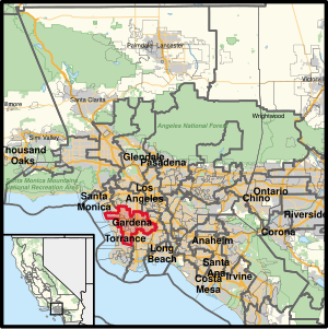
Hawthorne, California
City in California, United States
Distance: Approx. 502 meters
Latitude and longitude: 33.91722222,-118.34861111
Hawthorne is a city in the Los Angeles metropolitan area, located in southwestern Los Angeles County, California. It is part of a seventeen-city region commonly called the South Bay. As of the 2020 US census, Hawthorne had a population of 88,083.
Hawthorne High School (California)
Public school
Distance: Approx. 1842 meters
Latitude and longitude: 33.91728333,-118.36313056
Hawthorne High School is a public high school located in Hawthorne, California, within the Centinela Valley Union High School District. It opened in 1951 with 9th and 10th grades. The first graduating senior class was that of 1954.

Hawthorne Municipal Airport (California)
Municipal airport near Hawthorne, Los Angeles County, CA, USA
Distance: Approx. 989 meters
Latitude and longitude: 33.92277778,-118.33527778
Hawthorne Municipal Airport (IATA: HHR, ICAO: KHHR) (also known as Jack Northrop Field) is a public use airport in Hawthorne, California, United States. It is owned by the City of Hawthorne.
California's 43rd congressional district
U.S. House district for California
Distance: Approx. 1654 meters
Latitude and longitude: 33.90305556,-118.33638889
California's 43rd congressional district is a congressional district in the U.S. state of California that is currently represented by Democrat Maxine Waters. The district is centered in the southern part of Los Angeles County, and includes portions of the cities of Los Angeles (including LAX) and Torrance. It includes the entirety of the cities of Hawthorne, Lawndale, Gardena, Inglewood, and Lomita.

Beach Boys Historic Landmark
Historic site in Hawthorne, California
Distance: Approx. 1075 meters
Latitude and longitude: 33.925229,-118.337517
The Beach Boys Historic Landmark is a memorial which commemorates the site of the childhood home of Brian, Dennis, and Carl Wilson of The Beach Boys. The monument, located at 3701 W. 119th Street, Hawthorne, California, stands on the former location of the Wilsons' house, which was demolished in the mid-1980s during construction of the Century Freeway. Music industry notables such as Dick Clark and the Rock and Roll Hall of Fame were among the letter-writers who supported the BBHL's landmark application process.
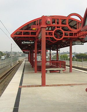
Crenshaw station
Los Angeles Metro Rail station
Distance: Approx. 1804 meters
Latitude and longitude: 33.9252,-118.3265
Crenshaw station is an elevated light rail station on the C Line of the Los Angeles Metro Rail system. It is located in the median of Interstate 105 (Century Freeway), above Crenshaw Boulevard, after which the station is named. The station is in the city of Hawthorne, California and opened as part of the Green Line on August 12, 1995.

Hawthorne Plaza
Abandoned shopping mall in Hawthorne, California
Distance: Approx. 910 meters
Latitude and longitude: 33.92128,-118.35144
Hawthorne Plaza is an abandoned enclosed shopping mall along Hawthorne Boulevard between 120th Street and El Segundo Boulevard in Hawthorne, California.
Hawthorne Math and Science Academy
Public school
Distance: Approx. 1084 meters
Latitude and longitude: 33.9204,-118.3541
Hawthorne Math and Science Academy is a state charter high school in Hawthorne, California, USA. It is part of the Hawthorne School District. Anakonia Matsumoto is the Principal.
All Olympia Gymnastics Center
Gymnastics gym in Calabasas, California
Distance: Approx. 1066 meters
Latitude and longitude: 33.913086,-118.332569
The All Olympia Gymnastics Center or AOGC is a one-facility gymnastics gym in Calabasas. A previous location in Hawthorne, California, was closed down. The head coaches are 1983 World Vault Champion Artur Akopyan and 1980 Olympian Galina Marinova.

Chips (coffee shop)
Historic coffee shop in Los Angeles, California, United States
Distance: Approx. 1260 meters
Latitude and longitude: 33.9253,-118.3522
Chips is a historic coffee shop in Los Angeles, California. It is an example of the Googie Architecture style of Modern Architecture. It was designed by Harry Harrison.

Boring test tunnel
Tunnel for testing Loop-based transportation
Distance: Approx. 1684 meters
Latitude and longitude: 33.9218,-118.326
The R&D Tunnel, also called the Hawthorne test tunnel or Boring test tunnel, is a 1.14 miles (1.83 km) tunnel in Hawthorne, California, for testing hyperloop and "loop-based transportation". It was completed by The Boring Company in late 2018. The single-bore tunnel was constructed during 2017 and 2018 using a 14-foot (4.2 m) diameter tunnel boring machine, giving a finished 12-foot (3.8 m) internal diameter.
Cockatoo Inn
Distance: Approx. 1614 meters
Latitude and longitude: 33.929817,-118.350907
Cockatoo Inn was a hotel located on Hawthorne Boulevard and Imperial Highway in Hawthorne, California. The hotel was a popular destination in Los Angeles, serving US politicians, Hollywood actors, and members of the American Mafia. Cockatoo gained a reputation for being a gathering place for the elites in Los Angeles.
Weather in this IP's area
clear sky
16 Celsius
17 Celsius
15 Celsius
18 Celsius
1009 hPa
90 %
1009 hPa
1007 hPa
10000 meters
0.45 m/s
1.79 m/s
137 degree
07:00:16
18:16:35