Country:
 USA
USARegion:
City:
Latitude and Longitude:
Time Zone:
Postal Code:
IP information under different IP Channel
ip-api
Country
Region
City
ASN
Time Zone
ISP
Blacklist
Proxy
Latitude
Longitude
Postal
Route
IPinfo
Country
Region
City
ASN
Time Zone
ISP
Blacklist
Proxy
Latitude
Longitude
Postal
Route
MaxMind
Country
Region
City
ASN
Time Zone
ISP
Blacklist
Proxy
Latitude
Longitude
Postal
Route
Luminati
Country
USRegion
ca
City
sandimas
ASN
Time Zone
America/Los_Angeles
ISP
TWC-20001-PACWEST
Latitude
Longitude
Postal
db-ip
Country
Region
City
ASN
Time Zone
ISP
Blacklist
Proxy
Latitude
Longitude
Postal
Route
ipdata
Country
Region
City
ASN
Time Zone
ISP
Blacklist
Proxy
Latitude
Longitude
Postal
Route
Popular places and events near this IP address
San Dimas, California
City in California, United States
Distance: Approx. 358 meters
Latitude and longitude: 34.10277778,-117.81611111
San Dimas (Spanish for "Saint Dismas") is a city in the San Gabriel Valley of Los Angeles County, California, United States. At the 2020 census, its population was 34,924. It historically took its name from San Dimas Canyon in the San Gabriel Mountains above the northern section of present-day San Dimas.

Frank G. Bonelli Regional Park
Park in Los Angeles County, California
Distance: Approx. 2414 meters
Latitude and longitude: 34.08472222,-117.80361111
Frank G. Bonelli Regional Park is a man-made recreational area in San Dimas, California, United States, in Los Angeles County. It is near the Orange Freeway (State Route 57), the Foothill Freeway (Interstate 210) and the San Bernardino Freeway (Interstate 10). It is named after former LA County Supervisor Frank G. Bonelli.
Raging Waters
California water park chain
Distance: Approx. 2990 meters
Latitude and longitude: 34.0781,-117.811
Raging Waters is a chain of two water theme parks in San Dimas, California, and Sydney, Australia. The parks are operated by Palace Entertainment and owned by its parent company Parques Reunidos, but they each contain different attractions. The parks are generally closed during the winter months.

Life Pacific University
Distance: Approx. 1584 meters
Latitude and longitude: 34.0993,-117.829
Life Pacific University (LPU) is a private Christian Bible college endorsed by the International Church of the Foursquare Gospel and located in San Dimas, California. LPU serves as the denomination's flagship institution for higher education.
Damien High School
Private, all-boys school in La Verne, , California, USA
Distance: Approx. 2292 meters
Latitude and longitude: 34.105,-117.78833333
Damien High School is an all-boys Roman Catholic high school in La Verne, in the U.S. state of California, named for Saint Damien of Molokai. It is located in and operated by the Roman Catholic Archdiocese of Los Angeles, part of the tri-school community including St. Lucy's Priory High School and Pomona Catholic High School.
Puddingstone Reservoir
Reservoir in Los Angeles County, California
Distance: Approx. 1682 meters
Latitude and longitude: 34.09027778,-117.80861111
Puddingstone Reservoir is a 250-acre (1 km²) artificial lake northeast of the interchange between the Orange Freeway (State Route 57) and the San Bernardino Freeway (Interstate 10) in Los Angeles County, California, United States. Activities include fishing, swimming, sailing, windsurfing, and camping. It is fed by Live Oak Wash and drains into Walnut Creek.
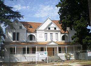
San Dimas Hotel
Historic hotel building in California, United States
Distance: Approx. 691 meters
Latitude and longitude: 34.1075,-117.80638889
The San Dimas Hotel, also known as Walker House, the Carruthers Home, and the San Dimas Mansion, is a historic structure in San Dimas, California, built by the San Jose Ranch Company in 1887. Originally built as a hotel, the 15,000-square-foot (1,400 m2) structure had 33 rooms and 14 fireplaces. The hotel was built in anticipation of a land boom that never happened, and it never had a paying guest.
San Dimas High School
Public school in San Dimas, California
Distance: Approx. 1117 meters
Latitude and longitude: 34.099,-117.823
San Dimas High School is a secondary school located in San Dimas, California, in the United States. It is part of the Bonita Unified School District. Most of the students come from Lone Hill Middle School which shares the same city block as the High School.
Puddingstone Dam
Dam in Los Angeles County, California
Distance: Approx. 1670 meters
Latitude and longitude: 34.09027778,-117.80916667
Puddingstone Dam is a 147 ft (45 m) high earth and rockfill dam in the San Gabriel Valley, within San Dimas in eastern Los Angeles County, California. The dam was built in 1928 by the Los Angeles County Department of Public Works, which continues to operate it.
La Casa de Carrión
Historic site in La Verne, California
Distance: Approx. 2454 meters
Latitude and longitude: 34.09648611,-117.78859722
La Casa de Carrión is an Adobe home built in 1868 by Saturnino Carrión (27 Nov 1831 - 25 Jun 1868). It is currently located in La Verne, California. The La Casa de Carrión was designated a California Historic Landmark (No.

San Dimas station
Future light rail station in San Dimas, California
Distance: Approx. 668 meters
Latitude and longitude: 34.105197,-117.805967
San Dimas station is a future at-grade light rail station in the Los Angeles Metro Rail system. The station is located on San Dimas Avenue near its intersection with Bonita Avenue along the Pasadena Subdivision right-of-way in San Dimas, California. It will be served by the A Line.

West San Dimas, California
Unincorporated community in California, United States
Distance: Approx. 3080 meters
Latitude and longitude: 34.08666667,-117.83833333
West San Dimas, also known as Mesa Oaks, is an unincorporated community in the eastern part of Los Angeles County in the U.S. state of California. The population was 309 according to the 2000 census. Locally, the area is known as "unincorporated Covina" and "unincorporated San Dimas".
Weather in this IP's area
clear sky
32 Celsius
33 Celsius
27 Celsius
35 Celsius
1009 hPa
38 %
1009 hPa
978 hPa
10000 meters
0.89 m/s
1.79 m/s
266 degree
9 %
06:29:29
19:09:02