Country:
 USA
USARegion:
City:
Latitude and Longitude:
Time Zone:
Postal Code:
IP information under different IP Channel
ip-api
Country
Region
City
ASN
Time Zone
ISP
Blacklist
Proxy
Latitude
Longitude
Postal
Route
IPinfo
Country
Region
City
ASN
Time Zone
ISP
Blacklist
Proxy
Latitude
Longitude
Postal
Route
MaxMind
Country
Region
City
ASN
Time Zone
ISP
Blacklist
Proxy
Latitude
Longitude
Postal
Route
Luminati
Country
USRegion
ca
City
sandiego
ASN
Time Zone
America/Los_Angeles
ISP
TWC-20001-PACWEST
Latitude
Longitude
Postal
db-ip
Country
Region
City
ASN
Time Zone
ISP
Blacklist
Proxy
Latitude
Longitude
Postal
Route
ipdata
Country
Region
City
ASN
Time Zone
ISP
Blacklist
Proxy
Latitude
Longitude
Postal
Route
Popular places and events near this IP address
Mira Mesa, San Diego
Neighborhood of San Diego in San Diego, California
Distance: Approx. 439 meters
Latitude and longitude: 32.91555556,-117.14388889
Mira Mesa (Spanish for "Table View") is a community and neighborhood in San Diego, California. The city-recognized Mira Mesa Community Plan Area is roughly bounded by Interstate 15 on the east, Interstate 805 on the west, the Los Peñasquitos Canyon on the north and Marine Corps Air Station Miramar on the south. Most of the community plan area is referred to as Mira Mesa; the community plan area also includes the neighborhoods of Sorrento Valley and Sorrento Mesa.

AleSmith Brewing Company
Craft brewery in San Diego, California
Distance: Approx. 2755 meters
Latitude and longitude: 32.89206667,-117.14468611
AleSmith Brewing Company is an American craft brewery located in San Diego, California. It specializes in handcrafted ales in a variety of styles. As of 2015 it produces about 25,000 barrels of beer a year.
Mira Mesa Senior High School
Public school in San Diego, California , United States
Distance: Approx. 631 meters
Latitude and longitude: 32.91083333,-117.14055556
Mira Mesa Senior High School (MMHS) is a public high school in San Diego, California. It is part of the San Diego Unified School District. The school serves the Mira Mesa community as well as students participating in the district's Voluntary Enrollment Exchange Program (VEEP).

Hourglass Field
Landing field of the United States Navy
Distance: Approx. 1809 meters
Latitude and longitude: 32.90833333,-117.1225
Hourglass Field was the popular name for an auxiliary landing field operated by the United States Navy before and during World War II in the northern part of San Diego, California. It is remembered as a racetrack in the regional road racing circuit and because a crackdown on unauthorized drag racing there triggered the El Cajon Boulevard Riot. A community college now occupies the site.

San Diego Miramar College
Community college in San Diego, California, US
Distance: Approx. 2017 meters
Latitude and longitude: 32.90714444,-117.12075
San Diego Miramar College (Miramar College or Miramar) is a public community college in San Diego, California. It is part of the San Diego Community College District and the California Community Colleges system. The college is accredited by the Accrediting Commission for Community and Junior Colleges (ACCJC).
Rancho Santa Maria de Los Peñasquitos
Historic ranch in San Diego, California
Distance: Approx. 2665 meters
Latitude and longitude: 32.938,-117.127
Rancho Santa Maria de Los Peñasquitos was a 8,486-acre (34.34 km2) Mexican land grant in present-day southwestern San Diego County, California, given in 1823 to Francisco María Ruiz. The name means "Saint Mary of the Little Cliffs". It encompassed the present-day communities of Mira Mesa, Carmel Valley, and Rancho Peñasquitos in northern San Diego, and was inland from the Torrey Pines State Natural Preserve bluffs.

Scripps Ranch High School
Public high school in Falcon Way, San Diego, California, United States
Distance: Approx. 2657 meters
Latitude and longitude: 32.9082,-117.1126
Scripps Ranch High School (SRHS) is a public high school in northeast San Diego, California, United States, that serves the Scripps Ranch community as well as students participating in the Voluntary Enrollment Exchange Program (VEEP) busing program of the San Diego Unified School District.

Los Peñasquitos Canyon Preserve
Distance: Approx. 3219 meters
Latitude and longitude: 32.93333333,-117.16722222
Los Peñasquitos Canyon Preserve is an urban park in San Diego, California. Stretching approximately 7 miles (11 km), the park encompasses some 4,000 acres (16 km2) of both Peñasquitos and Lopez canyons, and is one of the largest urban parks in the United States. The preserve is jointly owned and administered by the City of San Diego and the County of San Diego.
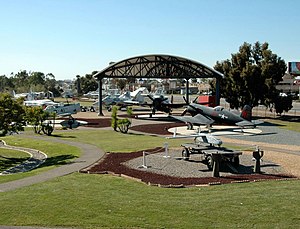
Flying Leatherneck Aviation Museum
Military aviation museum in California, United States
Distance: Approx. 2815 meters
Latitude and longitude: 32.89111111,-117.13916667
The Flying Leatherneck Aviation Museum is a United States Marine Corps aviation museum currently located at Marine Corps Air Station Miramar, San Diego, California. The museum contains exhibits and artifacts relating to the history and legacy of United States Marine Corps Aviation. The outdoor exhibits include 31 historical aircraft, multiple military vehicles and equipment.
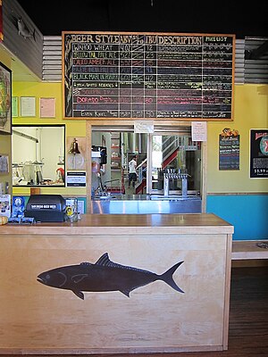
Ballast Point Brewing Company
Brewery in San Diego, California
Distance: Approx. 3659 meters
Latitude and longitude: 32.88753333,-117.15803056
Ballast Point Brewing Company is an American brewery founded in 1996 by Jack White in San Diego, California. Ballast Point Brewing Co. started in the back of Home Brew Mart, a homebrew supply store White founded in 1992.
Green Flash Brewing Company
Distance: Approx. 3718 meters
Latitude and longitude: 32.9068,-117.1774
Green Flash Brewing Company is an American craft brewery headquartered in the Mira Mesa neighborhood of San Diego, California, and founded in 2002. In early April 2018, the company sold to a group of investors, WC IPA LLC following a foreclosure by the company’s principal lender, Comerica Bank. Starting in 2013 it began expanding, seeking to cover all 50 US states and to export as well.
Southern California TRACON
Distance: Approx. 3475 meters
Latitude and longitude: 32.8913,-117.1172
Southern California TRACON (SoCal TRACON or SCT) is a terminal radar approach control (TRACON) facility in San Diego, California, that serves the Southern California region. It is a unit of the Air Traffic Organization of the Federal Aviation Administration (FAA). It is the busiest air traffic control facility in the world.
Weather in this IP's area
broken clouds
17 Celsius
17 Celsius
16 Celsius
18 Celsius
1010 hPa
87 %
1010 hPa
994 hPa
10000 meters
3.09 m/s
220 degree
75 %
06:54:31
18:12:42