Country:
 USA
USARegion:
City:
Latitude and Longitude:
Time Zone:
Postal Code:
IP information under different IP Channel
ip-api
Country
Region
City
ASN
Time Zone
ISP
Blacklist
Proxy
Latitude
Longitude
Postal
Route
IPinfo
Country
Region
City
ASN
Time Zone
ISP
Blacklist
Proxy
Latitude
Longitude
Postal
Route
MaxMind
Country
Region
City
ASN
Time Zone
ISP
Blacklist
Proxy
Latitude
Longitude
Postal
Route
Luminati
Country
USRegion
ca
City
sandimas
ASN
Time Zone
America/Los_Angeles
ISP
TWC-20001-PACWEST
Latitude
Longitude
Postal
db-ip
Country
Region
City
ASN
Time Zone
ISP
Blacklist
Proxy
Latitude
Longitude
Postal
Route
ipdata
Country
Region
City
ASN
Time Zone
ISP
Blacklist
Proxy
Latitude
Longitude
Postal
Route
Popular places and events near this IP address

San Marino, California
City in California, United States
Distance: Approx. 329 meters
Latitude and longitude: 34.12277778,-118.11305556
San Marino is a city in Los Angeles County, California, United States. It was incorporated on April 25, 1913. At the 2020 United States census the population was 12,513, a decline from the 2010 United States census.
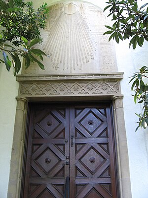
Huntington Library
Library, art museum, and garden in San Marino, California, US
Distance: Approx. 241 meters
Latitude and longitude: 34.12722222,-118.11
The Huntington Library, Art Museum and Botanical Gardens, known as The Huntington, is a collections-based educational and research institution established by Henry E. Huntington and Arabella Huntington in San Marino, California, United States. In addition to the library, the institution houses an extensive art collection with a focus on 18th and 19th century European art and 17th to mid-20th century American art. The property also has approximately 120 acres (49 ha) of specialized botanical landscaped gardens, including the "Japanese Garden", the "Desert Garden", and the "Chinese Garden".
San Marino High School
Public high school in San Marino, California, United States
Distance: Approx. 1124 meters
Latitude and longitude: 34.12646,-118.09908
San Marino High School (SMHS) is a public high school in San Marino, California, United States, and the only high school in the San Marino Unified School District, Los Angeles County. According to the 2015 California Academic Performance Index Survey, the district is the 52nd highest-performing school in California, with a score of 932 points out of 1,000 possible.

Edwin Hubble House
United States historic place
Distance: Approx. 922 meters
Latitude and longitude: 34.12305556,-118.12083333
The Edwin Hubble House is a historic house in San Marino, California. Built in 1925, it was the home of astronomer Edwin Hubble (1889–1953) for most of his professional life. Hubble is renowned as one of the greatest astronomers of the 20th century, whose discoveries revolutionized the science.
Hale Solar Laboratory
United States historic place
Distance: Approx. 1216 meters
Latitude and longitude: 34.13295278,-118.12061944
The Hale Solar Laboratory is a historic astronomical observatory in Pasadena, Los Angeles County, California, United States. Built in 1923, it was the laboratory of astronomer George Ellery Hale (1868-1938), a pioneering figure in the development of the discipline of astrophysics in the United States. The building, a distinctive blend of Mission Revival and Spanish Colonial Revival styles, was designated a National Historic Landmark in 1989.

Desert Garden Conservatory
Botanical greenhouse in San Marino, California
Distance: Approx. 239 meters
Latitude and longitude: 34.1272,-118.11
The Desert Garden Conservatory is a large botanical greenhouse and part of the Huntington Library, Art Collections and Botanical Gardens, in San Marino, California. It was constructed in 1985. The Desert Garden Conservatory is adjacent to the 10-acre (40,000 m2) Huntington Desert Garden itself.

Athenaeum at Caltech
Private social club at the California Institute of Technology
Distance: Approx. 1607 meters
Latitude and longitude: 34.136838,-118.121679
The Athenaeum is a faculty and private social club on the California Institute of Technology campus in Pasadena, California.
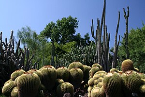
Huntington Desert Garden
Distance: Approx. 239 meters
Latitude and longitude: 34.1272,-118.11
The Huntington Desert Garden is part of The Huntington Library, Art Collections and Botanical Gardens in San Marino, California. The Desert Garden is one of the world's largest and oldest collections of cacti, succulents and other desert plants, collected from throughout the world. It contains plants from extreme environments, many of which were acquired by Henry E. Huntington and William Hertrich (the garden's first curator) in trips taken to several countries in North, Central and South America.

Lacy Park
Public park in San Marino, California, US
Distance: Approx. 1157 meters
Latitude and longitude: 34.12042,-118.12228
Lacy Park is a public park located in the city of San Marino, California. It is located in the San Rafael Hills, at 1485 Virginia Road. The park features large trees, open grass space, a rose garden, walking loops, tennis courts, as well as other amenities and areas.

Katherine Emery Estate
Historic house in California, United States
Distance: Approx. 1476 meters
Latitude and longitude: 34.12527778,-118.12722222
The Katherine Emery Estate is a historic house located at 1155 Oak Grove Avenue in San Marino, California. It is named for prominent California resident Katherine Sinclair Emery, who commissioned its construction, and has no connection to 1940s Hollywood character actress Katherine Emery. Prominent Southern California architect Myron Hunt designed the Tudor Revival house, which was completed in 1928.
Arden Villa
House in Pasadena, California
Distance: Approx. 1498 meters
Latitude and longitude: 34.13297,-118.12456
Arden Villa is a Palladian-style estate located in Pasadena, California, designed by the architectural firm Marston & Van Pelt in 1913 for William Kennon Jewett. Arden Villa has gained fame not only for its architectural splendor but also for its appearances in various movies and TV shows, earning it the nickname "Dynasty Mansion" due to its association with the popular 1980s TV drama Dynasty. Arden Villa was also used in the classic 1980's US TV series Knight Rider, as the base HQ for the fictional non-profit organization known as the Foundation for Law and Government.
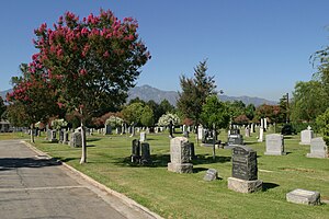
San Gabriel Cemetery
Cemetery in Los Angeles County, California
Distance: Approx. 1576 meters
Latitude and longitude: 34.1113,-118.10863
San Gabriel Cemetery is a historic cemetery in San Gabriel, California, United States. Founded in 1872, it contains over 19,000 burials in its approximately 15 acres (6 ha), including many of the founding leaders of San Gabriel and Los Angeles.
Weather in this IP's area
scattered clouds
16 Celsius
16 Celsius
14 Celsius
17 Celsius
1009 hPa
79 %
1009 hPa
988 hPa
10000 meters
0.45 m/s
0.89 m/s
270 degree
32 %
06:59:32
18:15:28