Country:
 USA
USARegion:
City:
Latitude and Longitude:
Time Zone:
Postal Code:
IP information under different IP Channel
ip-api
Country
Region
City
ASN
Time Zone
ISP
Blacklist
Proxy
Latitude
Longitude
Postal
Route
IPinfo
Country
Region
City
ASN
Time Zone
ISP
Blacklist
Proxy
Latitude
Longitude
Postal
Route
MaxMind
Country
Region
City
ASN
Time Zone
ISP
Blacklist
Proxy
Latitude
Longitude
Postal
Route
Luminati
Country
USRegion
ca
City
southpasadena
ASN
Time Zone
America/Los_Angeles
ISP
TWC-20001-PACWEST
Latitude
Longitude
Postal
db-ip
Country
Region
City
ASN
Time Zone
ISP
Blacklist
Proxy
Latitude
Longitude
Postal
Route
ipdata
Country
Region
City
ASN
Time Zone
ISP
Blacklist
Proxy
Latitude
Longitude
Postal
Route
Popular places and events near this IP address

South Pasadena, California
City in California, United States
Distance: Approx. 1071 meters
Latitude and longitude: 34.11611111,-118.15027778
South Pasadena is a city in Los Angeles County, California, United States. As of the 2010 census, it had a population of 25,619, up from 24,292 in the 2000 census. It is located in West San Gabriel Valley.
South Pasadena High School
Public secondary school in South Pasadena, California, United States
Distance: Approx. 320 meters
Latitude and longitude: 34.10938,-118.15373
South Pasadena High School (SPHS or "South Pas") is the one public high school serving grades 9–12 in the city of South Pasadena, California. With the South Pasadena Middle School and three elementary schools (Arroyo Vista, Marengo, and Monterey Hills) it makes up the South Pasadena Unified School District. Established in 1905, it is the only public high school in South Pasadena.

Raymond Hotel
Hotel in South Pasadena, California
Distance: Approx. 1933 meters
Latitude and longitude: 34.1239924,-118.1481771
The Raymond Hotel was a hotel in South Pasadena, California, and first major resort hotel of the San Gabriel Valley. Largely a winter residence for wealthy Easterners, it was built by Mr. Walter Raymond of Raymond & Whitcomb Travel Agency of Boston, Massachusetts.
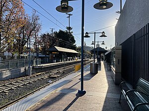
South Pasadena station
Los Angeles Metro Rail station
Distance: Approx. 836 meters
Latitude and longitude: 34.1157,-118.1573
South Pasadena station (formerly Mission station) is an at-grade light rail station on the A Line of the Los Angeles Metro Rail system. It is located at the intersection of Mission Street and Meridian Avenue in South Pasadena, California, after which the station is named. The station opened on July 26, 2003, as part of the original Gold Line, then known as the "Pasadena Metro Blue Line" project.

Cawston Ostrich Farm
Los Angeles tourist attraction (1886–1935)
Distance: Approx. 1588 meters
Latitude and longitude: 34.1125,-118.17333333
Cawston Ostrich Farm, located in South Pasadena, California, United States, was opened in 1896 by Edwin Cawston. It was one of America's first ostrich farms and was located in the Arroyo Seco Valley just three miles (5 km) north of downtown Los Angeles and occupied nine acres. In 1887, the company built Hollywood's first railway, linking the farm to Hollywood.
Rancho Huerta de Cuati
Mexican land grant in modern Los Angeles County, California
Distance: Approx. 1784 meters
Latitude and longitude: 34.12,-118.17
Rancho Huerta de Cuati was a 127-acre (0.51 km2) Mexican land grant in the San Rafael Hills area of present-day Los Angeles County, California given in 1838 by governor Juan Alvarado to Victoria Reid. The name means "Cuati Garden" in Spanish. The rancho included present-day Alhambra, San Marino, South Pasadena, and Pasadena—and Lake Wilson (now San Marino's Lacy Park).

Howard Longley House
Historic house in California, United States
Distance: Approx. 1384 meters
Latitude and longitude: 34.12055556,-118.15527778
The Howard Longley House is a historic house in South Pasadena, California, U.S. In 1897, Greene and Greene recorded job no. 23 as a residence for Howard and Etta Longley at 1005 Buena Vista Street, with a valuation of $3,876. Mr.

Miltimore House
Historic house in California, United States
Distance: Approx. 1448 meters
Latitude and longitude: 34.11138889,-118.14166667
The Miltimore House is a historic house in South Pasadena, California, U.S.. It was designed by architect Irving Gill. It has been listed on the National Register of Historic Places since March 24, 1972.
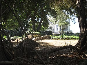
Wynyate
Historic house in California, United States
Distance: Approx. 304 meters
Latitude and longitude: 34.11083333,-118.15777778
Wynyate is a historic house in South Pasadena, California, U.S.. It was built circa 1887 for Donald M. Graham, the first mayor of Pasadena, and his wife, author Margaret Collier Graham. It was designed in the Victorian architectural style.

Adobe Flores
Historic house in South Pasadena, California
Distance: Approx. 1623 meters
Latitude and longitude: 34.11972222,-118.14611111
Adobe Flores is a historic house in South Pasadena, California, U.S. It was built on Rancho San Pascual from 1838 to 1845. It was named for José María Flores. It was restored by architect Carleton Winslow in 1919.

Garfield House (South Pasadena, California)
United States historic place
Distance: Approx. 1379 meters
Latitude and longitude: 34.12055556,-118.15583333
The Garfield House is a historic two-story house in South Pasadena, California. It was built in 1904 for First Lady Lucretia Garfield, the widow of James A. Garfield who served as the 20th President of the United States in 1881. It was designed by Greene & Greene in the American Craftsman style.
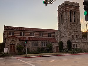
St. James' Episcopal Church (South Pasadena, California)
Church in South Pasadena, California
Distance: Approx. 489 meters
Latitude and longitude: 34.1116991,-118.153701
St. James' Episcopal Church is a parish of the Episcopal Church in South Pasadena, California, and part of the Episcopal Diocese of Los Angeles.
Weather in this IP's area
clear sky
30 Celsius
30 Celsius
25 Celsius
34 Celsius
1008 hPa
41 %
1008 hPa
986 hPa
10000 meters
1.74 m/s
2.64 m/s
146 degree
1 %
06:30:51
19:10:24