Country:
 USA
USARegion:
City:
Latitude and Longitude:
Time Zone:
Postal Code:
IP information under different IP Channel
ip-api
Country
Region
City
ASN
Time Zone
ISP
Blacklist
Proxy
Latitude
Longitude
Postal
Route
IPinfo
Country
Region
City
ASN
Time Zone
ISP
Blacklist
Proxy
Latitude
Longitude
Postal
Route
MaxMind
Country
Region
City
ASN
Time Zone
ISP
Blacklist
Proxy
Latitude
Longitude
Postal
Route
Luminati
Country
USRegion
ca
City
santamonica
ASN
Time Zone
America/Los_Angeles
ISP
TWC-20001-PACWEST
Latitude
Longitude
Postal
db-ip
Country
Region
City
ASN
Time Zone
ISP
Blacklist
Proxy
Latitude
Longitude
Postal
Route
ipdata
Country
Region
City
ASN
Time Zone
ISP
Blacklist
Proxy
Latitude
Longitude
Postal
Route
Popular places and events near this IP address

Crossroads School (Santa Monica, California)
School in Santa Monica, California, United States
Distance: Approx. 712 meters
Latitude and longitude: 34.02444444,-118.47388889
Crossroads School for Arts & Sciences is a private/independent, college preparatory school in Santa Monica, California, United States. The school is a former member of the G20 Schools Group.
Playboy Studio West
Distance: Approx. 424 meters
Latitude and longitude: 34.028427,-118.47659
Playboy Studio West is located at 2112 Broadway Avenue, Santa Monica, California. It is one of Playboy's key studio facilities for Playboy photographers to shoot centerfolds and Playmate pictorials. Many models had their test nude shoots taken at this facility prior to being considered for a Playmate pictorial in Playboy.
Bergamot (arts center)
Art gallery facility in Santa Monica, California, US
Distance: Approx. 692 meters
Latitude and longitude: 34.027677,-118.46652
Bergamot Station Arts Center is a Santa Monica facility housing many different private art galleries and appears in most tourist guides as a primary cultural destination. Opened September 17, 1994 as Bergamot Station the campus-like complex is owned by the city of Santa Monica and presently managed by the Worthe Group.

Saint John's Health Center
Hospital in California, United States
Distance: Approx. 554 meters
Latitude and longitude: 34.0306,-118.479
Providence Saint John's Health Center, formerly St. Johns Hospital and Health Center, is a private not-for-profit, Roman Catholic hospital in Santa Monica, California, United States. The hospital was founded in 1942 by the Sisters of Charity of Leavenworth.

26th Street/Bergamot station
Light rail station
Distance: Approx. 431 meters
Latitude and longitude: 34.0279,-118.4699
26th Street/Bergamot station is an at-grade light rail station in the Los Angeles Metro Rail system. It is located near the intersection of 26th Street and Olympic Boulevard in Santa Monica, California and near the Bergamot Station Arts Center. The station is served by the E Line.

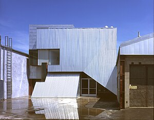
Koning Eizenberg Architecture
Architectural firm located in Santa Monica, California, United States
Distance: Approx. 118 meters
Latitude and longitude: 34.03135334,-118.47409273
Koning Eizenberg Architecture (KEA) is an architecture firm located in Santa Monica, California established in 1981. The firm is recognized for a range of project types including: adaptive reuse of historic buildings, educational facilities, community places, and housing. Principals Hank Koning, Julie Eizenberg, Brian Lane, and Nathan Bishop work collaboratively with developers, cities and not-for-profit clients.
18th Street Arts Center
Arts center in Santa Monica, California, United States
Distance: Approx. 845 meters
Latitude and longitude: 34.024157,-118.477424
18th Street Arts Center is a nonprofit arts center in Santa Monica, California. It was founded in 1988 and is the longest running artist residency center in Southern California. 18th Street Arts Center’s residency program hosts 60 or more American and international artists and curators a year.

Lighthouse Christian Academy
Private school in Santa Monica, California, United States
Distance: Approx. 467 meters
Latitude and longitude: 34.034774,-118.471384
Lighthouse Christian Academy, in Santa Monica, California, is an American private, college preparatory Christian school founded in 1992 as an outgrowth of the Lighthouse Church School (founded in 1983). As of 2007, it is accredited by the International Christian Accrediting Association, an independent Christian educational association.

Rip City Skates
Skate shop in Santa Monica, California, US
Distance: Approx. 407 meters
Latitude and longitude: 34.03444444,-118.47333333
Rip City Skates, known also as Rip City, is the longest running skate shop in Santa Monica, California, established in 1978.

Gandara Park
Park in Santa Monica, California, United States
Distance: Approx. 824 meters
Latitude and longitude: 34.0275,-118.465
Gandara Park is a 3.8 acre residential park located in Santa Monica, California, United States.

Douglas Park (Santa Monica)
Park in Santa Monica, California, United States
Distance: Approx. 796 meters
Latitude and longitude: 34.03569,-118.4793
Douglas Park is a 10.7 acres (4.3 ha) park in Santa Monica, California. Formerly the site of an aircraft factory and movie studio lot, the park is named after Donald Douglas and hosts a number of facilities, including a bowling green and Los Angeles County's largest municipal pond.
1976 Computer Learning Center shooting
Mass shooting in California
Distance: Approx. 803 meters
Latitude and longitude: 34.037902,-118.4745492
On February 19, 1976, 18-year-old student Neil Jordan "Bishop" Liebeskind opened fire with a sawed-off 12-gauge shotgun at the Computer Learning Center, an independent computer school in downtown Los Angeles. After killing one student and wounding seven others in a classroom, he fled to the parking lot. Security guards for a television crew nearby overheard the shooting, so they ran to the school and ordered Liebeskind to surrender.
Weather in this IP's area
clear sky
32 Celsius
34 Celsius
26 Celsius
37 Celsius
1006 hPa
48 %
1006 hPa
1001 hPa
10000 meters
3.09 m/s
250 degree
06:32:10
19:11:37